|
|
Title | Collection Number And Name | Photo Number |
| 176 |
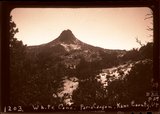 |
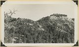
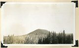
White Cone ("Tabbtimp"), outlier of Navajo sandstone at head of Starlight Canyon. Wall of Paria Canyon (lower right). Kane County, Utah, 1943. | P0013 Herbert E. Gregory Photograph Collection | P0013n12_029_illus1203_neg |
| 177 |
 |
"Pryor Knoll, eroded basaltic cone and lava flows over Cretaceous rocks. View looking northwest. Western edge of Kolob Terrace. Just back of the yellow pines are the cliffs at the head of the westward flowing Shurtz Creek. Iron County, UT, 1942 | P0013 Herbert E. Gregory Photograph Collection | P0013n11_190_2831 |
| 178 |
 |
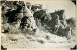
Arrangement of formations at Squaw Canyon along the line of the Kanarra fold. Triassic; Navajo upper Jurassic (Carmel, Entrada, Curtis, Winsor); Cretaceous. Steep dips of lower formations progressively flatten eastward (right). Iron County, UT, 1942 | P0013 Herbert E. Gregory Photograph Collection | P0013n11_188_2828 |
| 179 |
 |
Basalt flow from Horsetail Mountain near its termination (eastward; right), Iron County, UT, 1942 | P0013 Herbert E. Gregory Photograph Collection | P0013n11_184_2822 |
| 180 |
 |
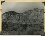
Black Ledge. Cliff of rhyolite that for about 20 miles forms the rim of the Markagunt Plateau. The escarpment is the upthrown side of a fault concealed by the talus. Hoosier Lake, Iron County, UT, 1942 | P0013 Herbert E. Gregory Photograph Collection | P0013n11_181_2816 |
| 181 |
 |
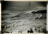
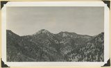
Black Mountain culminating in Richardson Peak (altitude 9900 feet), viewed from southwest. Eroded crater and extensive basaltic flows overlying Cretaceous and Tertiary sediments. View looking north east edge of Kolob Terrace. Iron County, UT, 1942 | P0013 Herbert E. Gregory Photograph Collection | P0013n11_189_2830 |
| 182 |
 |
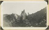
Braffit Point. Mass of conglomerate in the Kaiparowits formation, branch of Parowan Canyon, Iron County, UT, 1942 | P0013 Herbert E. Gregory Photograph Collection | P0013n11_178_2811 |
| 183 |
 |
Brian Head formation capped by lava. Branch of Limekiln Canyon. Garfield County, UT. 1942 | P0013 Herbert E. Gregory Photograph Collection | P0013n11_187_2825 |
| 184 |
 |
Carmel formation. Coal Canyon, Iron County, UT. 1942 | P0013 Herbert E. Gregory Photograph Collection | P0013n11_179_2813 |
| 185 |
 |
Carmel formation. Coal Canyon, Iron County, UT. 1942 | P0013 Herbert E. Gregory Photograph Collection | P0013n11_179_2812 |
| 186 |
 |
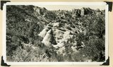
Conglomerate and underlying arkosic sandstone, Kaiparowits formation, Bowery Canyon, Iron County, UT, 1942 | P0013 Herbert E. Gregory Photograph Collection | P0013n11_178_2810 |
| 187 |
 |
Conglomerate within the Wasatch formation (top and bottom). Bowery Canyon. Iron County, UT, 1942 | P0013 Herbert E. Gregory Photograph Collection | P0013n11_194_2839 |
| 188 |
 |
Face of Hurricane Cliffs between Kanarra and Murie Creeks. Westward dipping lower Moenkopi strata. Edge of South Hills (left center), Square Mountain (left distance). Iron County, UT, 1942 | P0013 Herbert E. Gregory Photograph Collection | P0013n11_185_2823 |
| 189 |
 |
Fault contact of Carmel (right) and Curtis (left). Coal Canyon above the mouth of Rocky Hollow. Iron County, UT, 1942 | P0013 Herbert E. Gregory Photograph Collection | P0013n11_194_2840 |
| 190 |
 |
Fault near the mouth of Maple Canyon looking north, upthrown block at left. Iron County, UT, 1942 | P0013 Herbert E. Gregory Photograph Collection | P0013n11_197_2844 |
| 191 |
 |
Fault, Wasatch limestone (extreme right) in horizontal contact with undifferentiated Cretaceous. Parowan Canyon. Iron County, UT | P0013 Herbert E. Gregory Photograph Collection | P0013n11_166_2787 |
| 192 |
 |
Hancock Peak. Volcanic cone, Iron County, UT, 1942 | P0013 Herbert E. Gregory Photograph Collection | P0013n11_183_2820 |
| 193 |
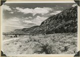 |
Hurricane Cliffs looking north across mouth of Swayne Creek. Iron County | P0013 Herbert E. Gregory Photograph Collection | P0013n11_170_2795 |
| 194 |
 |
Hurricane Cliffs, formed by westward dipping Moenkopi strata involved in the Kanarra fold. Hurricane fault passes along the base and through the valley of Murie Creek (left); thick alluvium on the downthrown block (foreground). Iron County, UT, 1942 | P0013 Herbert E. Gregory Photograph Collection | P0013n11_195_2841 |
| 195 |
 |
Kaiparowits formation (Cretaceous) overlain by the Wasatch Tertiary. Bowery Canyon, Iron County, 1942 | P0013 Herbert E. Gregory Photograph Collection | P0013n11_176_2807 |
| 196 |
 |
Kaiparowits formation (Cretaceous) overlain by the Wasatch Tertiary. Bowery Canyon, Iron County, 1942 | P0013 Herbert E. Gregory Photograph Collection | P0013n11_177_2808 |
| 197 |
 |
Kaiparowits formation (Cretaceous) overlain by the Wasatch Tertiary. Bowery Canyon, Iron County, 1942 | P0013 Herbert E. Gregory Photograph Collection | P0013n11_177_2809 |
| 198 |
 |
Lake like no 2837, about a half mile down valley | P0013 Herbert E. Gregory Photograph Collection | P0013n11_193_2838 |
| 199 |
 |
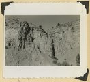
Log Hollow fault (Cretaceous), Kaiparowits formation, on upthrown side (middle and right) in contact with Tertiary (left). Estimated displacement 700 feet. Bowery Canyon, Iron County, UT. 1942 | P0013 Herbert E. Gregory Photograph Collection | P0013n11_174_2802 |
| 200 |
 |
Moenkopi beds upturned in the Kanarra fold and broken by a fault. Lawrence Canyon, Iron County, UT, 1942 | P0013 Herbert E. Gregory Photograph Collection | P0013n11_197_2845 |