|
|
Title | Collection Number And Name | Photo Number |
| 176 |
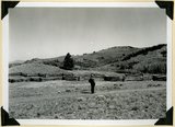 |
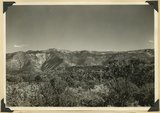
Surface of Kolob Terrace near Pryor Knoll, Iron County | P0013 Herbert E. Gregory Photograph Collection | P0013n11_169_2793 |
| 177 |
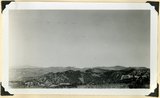 |
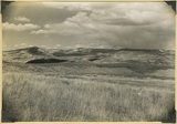
Surface of the Piute Highlands looking north from Mithcell Ridge, Iron County, UT, 1942 | P0013 Herbert E. Gregory Photograph Collection | P0013n11_175_2805 |
| 178 |
 |
Termination of a basalt flow from Hancock Peak, overriding Wasatch limestone, left. Branch of Mammoth Creek, Iron County, UT, 1942 | P0013 Herbert E. Gregory Photograph Collection | P0013n11_184_2821 |
| 179 |
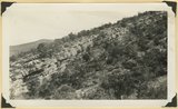 |
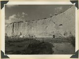
Tilted Cretaceous strata that terminate westward left at the Hurricane fault. Canyon southeast of Summit, Iron County, UT. 1942 | P0013 Herbert E. Gregory Photograph Collection | P0013n11_180_2814 |
| 180 |
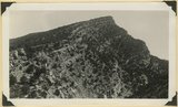 |
Tilted Cretaceous strata that terminate westward left at the Hurricane fault. Canyon southeast of Summit, Iron County, UT. 1942. Wall of Fiddler Canyon | P0013 Herbert E. Gregory Photograph Collection | P0013n11_180_2815 |
| 181 |
 |
View looking north from near head of South Creek across Coal Canyon, Iron County, UT | P0013 Herbert E. Gregory Photograph Collection | P0013n11_173_2801 |
| 182 |
 |
View looking northeast across Kolob Terrace developed on Cretaceous strata. Pink Cliffs Tertiary (skyline), Black Mountain Volcano (upper left). Iron County, UT, 1942 | P0013 Herbert E. Gregory Photograph Collection | P0013n11_190_2832 |
| 183 |
 |
View looking northeast across Kolob Terrace. Basalt (foreground), Cretaceous trenched by Crystal Creek (middle), Pink Cliffs-Wasatch (skyline), lower east slope of Black Mountain (extreme left), 'The Gap,' twin peaks (right skyline), stands just south of Navajo Lake. Iron County, UT, 1942 | P0013 Herbert E. Gregory Photograph Collection | P0013n11_188_2827 |
| 184 |
 |
View south from the base of Horseranch Mountain, across the three deep canyon branches of Taylor Creek. Timber Top Mesa (middle skyline); Navajo sandstone (in walls); Carmel (general surface); Entrada (left center); Smith Mesa, Triassic rocks (upper right); towers of Zion National Park (upper left). Iron County, UT, 1942 | P0013 Herbert E. Gregory Photograph Collection | P0013n11_196_2843 |
| 185 |
 |
Virgin limestone (left) and Shnabkaib member of the Moenkopi in vertical position. Kanarra Canyon, Iron County, UT, 1942 | P0013 Herbert E. Gregory Photograph Collection | P0013n11_183_2819 |
| 186 |
 |
Westward tilting Moenkopi strata; Timpoweap, lower red, Virgin and Shnabkaib members. Mouth of Kanarra Canyon. Iron Co, UT | P0013 Herbert E. Gregory Photograph Collection | P0013n11_170_2794 |
| 187 |
 |
'Elephant feet'. Wingate sandstone, Kayenta above. Three Lakes Canyon, Kane County, UT, 1939 | P0013 Herbert E. Gregory Photograph Collection | P0013n11_063_2631 |
| 188 |
 |
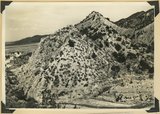
'The Granary': one of many natural cavities in Wingate sandstone utilized for storage, Johnson Canyon, Kane County, UT, 1939 | P0013 Herbert E. Gregory Photograph Collection | P0013n11_078_2658 |
| 189 |
 |
'White Throne' remnant of Navajo sandstone in branch of Paria River. Kane County, UT, 1940 | P0013 Herbert E. Gregory Photograph Collection | P0013n11_108_2699 |
| 190 |
 |
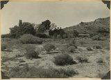
'Winsor Castle', old fort at Pipe Springs, looking south over Unikaret Plateau, Kanab Canyon upper right | P0013 Herbert E. Gregory Photograph Collection | P0013n11_101_2690 |
| 191 |
 |
'Winsor Castle,' old stone fort at Pipe Springs, Mohave County, AZ. Sevier fault passes between Navajo sandstone." (upper right) and lower Moenkopi (foreground). 1939 | P0013 Herbert E. Gregory Photograph Collection | P0013n11_090_2672 |
| 192 |
 |
Alluvial terraces made since 1900, Johnson Creek, Kane County, UT, 1939 | P0013 Herbert E. Gregory Photograph Collection | P0013n11_077_2656 |
| 193 |
 |
Alluvial terraces on Kanab Creek near mouth of Tiny Canyon, Kane County, UT. 1939. Excavated since 1882 | P0013 Herbert E. Gregory Photograph Collection | P0013n11_090_2673 |
| 194 |
 |
Alluvial terraces, Parunuweap Valley between Orderville and Mt. Carmel. Lie unevenly on Tropic shale. Kane County, UT. 1937 | P0013 Herbert E. Gregory Photograph Collection | P0013n11_022_2557 |
| 195 |
 |
Alluvial wall of trench dug since 1920(?), post Wasatch marls at base. Red Creek. Garfield County, UT, 1940 | P0013 Herbert E. Gregory Photograph Collection | P0013n11_128_2720 |
| 196 |
 |
Ancient gravels, (left center) form terrace both sides of Virgin River between Rockville and Grafton. Rest unconformably on middle Moenkopi beds, upper Moenkopi, Shinarump, Chinle, and Navajo above. Washington County, UT, 1939 | P0013 Herbert E. Gregory Photograph Collection | P0013n11_062_2630 |
| 197 |
 |
Ancient talus (right foreground) and talus now forming at base of Kinesava mountain, Zion National Park, Washington County, UT, 1939 | P0013 Herbert E. Gregory Photograph Collection | P0013n11_041_2590 |
| 198 |
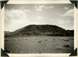 |
Bald Knoll Volcanic Cone near head of Johnson Creek. Kane County, UT. 1940 | P0013 Herbert E. Gregory Photograph Collection | P0013n11_118_2709 |
| 199 |
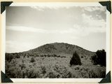 |
Bald Knoll Volcanic Cone near head of Johnson Creek. Kane County, UT. 1940 | P0013 Herbert E. Gregory Photograph Collection | P0013n11_118_2708 |
| 200 |
 |
Base of Straight Cliffs formation (Cretaceous) at Orderville. Tropic shale forms slope at bottom. Kane County, UT, 1939 | P0013 Herbert E. Gregory Photograph Collection | P0013n11_045_2598 |