Home
Browse
Ask Us
Chat
Harmful Language Statement
Log in
Advanced Search
Year
1867
1868
1869
1870
1871
1872
1873
1874
1875
1876
1877
1878
1879
1880
1881
1882
1883
1884
1885
1886
1887
1888
1889
1890
1891
1892
1893
1894
1895
1896
1897
1898
1899
1900
1901
1902
1903
1904
1905
1906
1907
1908
1909
1910
1911
1912
1913
1914
1915
1916
1917
1918
1919
1920
1921
1922
1923
1924
1925
1926
1927
1928
1929
1930
1931
1932
1933
1934
1935
1936
1937
1938
1939
1940
1941
1942
1943
1944
1945
1946
1947
1948
1949
1950
1951
1952
1953
1954
1955
1956
1957
1958
1959
1960
1961
1962
1963
1964
1965
1966
1967
1968
1969
1970
1971
1972
1973
1974
1975
1976
1977
1978
1979
1980
1981
1982
1983
1984
1985
1986
1987
1988
1989
1990
1991
1992
1993
1994
1995
1996
1997
1998
1999
2000
2001
2002
2003
2004
2005
2006
2007
2008
2009
2010
2011
2012
2013
2014
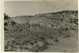
2015
2016
2017
2018
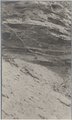
2019
2020
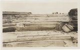
2021
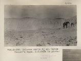
2022
2023
2024
TO
1867
1868
1869
1870
1871
1872
1873
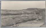
1874
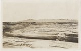
1875
1876
1877
1878
1879
1880
1881
1882
1883
1884
1885
1886
1887
1888
1889
1890
1891
1892
1893
1894
1895
1896
1897
1898
1899
1900
1901
1902
1903
1904
1905
1906
1907
1908
1909
1910
1911
1912
1913
1914
1915
1916
1917
1918
1919
1920
1921
1922
1923
1924
1925
1926
1927
1928
1929
1930
1931
1932
1933
1934
1935
1936
1937
1938
1939
1940
1941
1942
1943
1944
1945
1946
1947
1948
1949
1950
1951
1952
1953
1954
1955
1956
1957
1958
1959
1960
1961
1962
1963
1964
1965
1966
1967
1968
1969
1970
1971
1972
1973
1974
1975
1976
1977
1978
1979
1980
1981
1982
1983
1984
1985
1986
1987
1988
1989
1990
1991
1992
1993
1994
1995
1996
1997
1998
1999
2000
2001
2002
2003
2004
2005
2006
2007
2008
2009
2010
2011
2012
2013
2014
2015
2016
2017
2018
2019
2020
2021
2022
2023
2024
Type
Image
3,523
Text
288
Image/StillImage
149
Sound
5
Format
image/jpeg
3,602
application/pdf
1,181
Collection
44th Bomb Group - 8 Ball Tails Magazine
1
Alan K Engen Papers
2
American West Center Research Projects
12
Angus Munn Woodbury Papers
1
Athletics
13
Charles James Nabors Papers
3
Civilian Conservation Corps Newslette...
1
Classified Photographs
7
College of Law Publications
54
College of Nursing
13
Colorado Riverbed Case
2
Continuum
7
Cycling Utah
1
Electronic University Archive
49
Elias Hicks Blackburn Papers, 1848-1908
2
Everett L. Cooley Oral History Project
15
Glen Canyon
1
Graduate Nursing Project
1
Hinckley Journal of Politics
1
Historic and Prehistoric Publications
133
Honors Theses Closed Archive
1
Honors Theses Open Access
4
Illuminations
2
Intermountain Ski Instructors Associa...
10
Juanita Brooks Papers
3
Kem C. Gardner Policy Institute Colle...
1
Linford and Richards Family Collection
4
Manuscripts
4
Marriner S. Eccles Papers
19
Marriott Digital Publishing Archive
1
Marriott Library Digital Stacks
1
Marriott Library Items
1
Midvale Museum
1
Mormon Settlement in Arizona
2
NOVEL - Journal of Neuro-Ophthalmology
3
Neighborhood Partners
1
Photo Archives
3,525
Public Affairs of Health Sciences Center
4
Rare Books Collection
7
Theater Programs Collection, 1866-1995
1
Theses & Dissertations
37
UAIDA Main Collection
144
UMFA Docent Archive
1
UScholar Works
7
University of Utah Board of Regents M...
2
University of Utah Press Open Access ...
5
Uranium Oral Histories
1
Utah City Directories Collection
557
Utah Historic Building Records
60
Utah Historical Society Oral History ...
1
Utah Medical Association Bulletin
13
Utah National Register Nomination Forms
1
Utah Pharmacy Digest
6
Utah State Board Of Regents
6
Utah's Urban Pioneer Folk Music Reviv...
1
Utonian Yearbooks
13
Western Waters AZ. vs CA.
1
Western Waters Documents
4
Western Waters NEH
9
More
151
-
175
of
4,783
<
2
3
4
5
6
7
8
9
10
11
>
Gallery view
Number of results to display per page
10
25
50
100
200
Sort by Relevance
Sort by Title A-Z
Sort by Title Z-A
Sort by Date Ascending
Sort by Date Descending
Sort by Last Modified Ascending
Sort by Last Modified Descending
Title
Date
Type
Setname
151
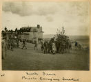
Snake dance, priests carrying snakes
1900
Image
uum_map
152
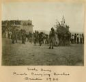
Snake dance, priests carrying snakes, Oraibi, 1900
1900
Image
uum_map
153
Snake dance, priests dancing
1900
Image
uum_map
154
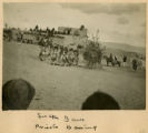
Snake dance, priests in line
1900
Image
uum_map
155
Barohoini Natural Bridge, 10+ mi. northwest of Navajo Mt., Utah in LaPlata strata, 1910. Looking down stream northwest from distance of 1+ mi. (Photo G176)
1910
Image
uum_map
156
Goodridge Bridge. Edna Hope Gregory, Baker, McKnight. San Juan County, UT, 1927
1927
Image
uum_map
157
288.(N-M.73). Gregory. Beautiful Valley, 1909
1909
Image/StillImage
uaida_main
158
Bridal couple, Lower Oraibi Wash. 1909
1909
Image
uum_map
159
Cliff, LaPlata on Dolores at mouth of Sagy at Sosi canyon, AZ. 1910 (Photo G166)
1910
Image
uum_map
160
Cross-bedding, Moencopie (?) strata, 6± mi. northeast of Agathla Needle, Ariz., 1910 (Photo G157)
1910
Image
uum_map
161
Distant (10 mi.) view of Navaho Mt., southeast (Photo G368)
1913
Image
uum_map
162
Dolores Badlands 1 1/2 mile west of Nashlini. (I-5 & I-7 in film book just like this) (Photo N-M135)
1913
Image
uum_map
163
Dolores marls 8± mi. below Tanner's Spgs. E.C.Case in photo (Photo G398)
1913
Image
uum_map
164
Dunes filling Reservoir Canyon, Tuba (IV-8 in film book is also like this) (Photo G441)
1913
Image
uum_map
165
Erosion column. Block of Dakota resting on LaPlata, Southeast of Gallup on west line of Wingate reservation. VII, 3. 1911 (Photo G189)
1911
Image
uum_map
166
Erosion pillar, McElmo valley, 15± miles west of Cortez, Colorado. 1910
1910
Image
uum_map
167
General view of upper Moencopie strata, looking northeast toward Monument Pass. Taken from a point 8± mi. northeast of Agathla Needle, Ariz., 1910 (Photo G158)
1910
Image
uum_map
168
Grand Falls, Little Colorado (Photo N-M175)
1913
Image
uum_map
169
Grand Falls, panorama (Photos G415)
1913
Image
uum_map
170
Grand Falls, panorama (Photos G416)
1913
Image
uum_map
171
Gypsum in Permian. 2± mi. east of Holbrook (Photo G402)
1913
Image
uum_map
172
Joints in LaPlata sandstone. Head of Pahute canyon, UT. 1910 (Photo G183)
1910
Image
uum_map
173
Kaibab limestone (lower wall,left, breccia (marks unconformable contact), and basal Moenkopi limestone and shales. Mouth of Kaibab Gulch. Kane County, UT, 1944
1944
Image
uum_map
174
McElmo strata, Holly's ranch, McElmo valley, Colorado, 33± miles west of Cortez, Colorado. 1910 (Photo G-125)
1910
Image
uum_map
175
McElmo strata, north bank of San Juan River, 10± mi. below Aneth, Utah, 1910 (Photo G129)
1910
Image
uum_map
151
-
175
of
4,783
<
2
3
4
5
6
7
8
9
10
11
>