|
|
Title | Collection Number And Name | Photo Number |
| 151 |
 |
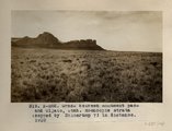
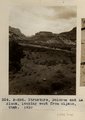
One of the "monuments," Monument Pass, Utah (Moencopie strata), 1910 (Photo G139) | P0013 Herbert E. Gregory Photograph Collection | P0013n04_13_0536 |
| 152 |
 |
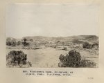
Grass between Monument Pass and Oljato, Utah. Moencopie strata (capped by Shinarump?) in distance, 1910 (Photo N-M82) | P0013 Herbert E. Gregory Photograph Collection | P0013n04_14_0537 |
| 153 |
 |
Grass between Monument Pass and Oljato, Utah. Moencopie strata (capped by Shinarump?) in distance, 1910 (Photo N-M82) | P0013 Herbert E. Gregory Photograph Collection | P0013n04_14_0537 |
| 154 |
 |
Wind-swept mesa, Shinarump, at Oljato, Utah (S.M. Young photo) | P0013 Herbert E. Gregory Photograph Collection | P0013n04_15_0538 |
| 155 |
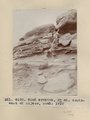 |
Wind erosion, 3+ mi. southwest of Oljato, Utah, 1910 (Photo G140) | P0013 Herbert E. Gregory Photograph Collection | P0013n04_16_0539 |
| 156 |
 |
Wind erosion, 3± miles southwest of Oljato, Utah, 1910 (Photo G140) | P0013 Herbert E. Gregory Photograph Collection | P0013n04_16_0539 |
| 157 |
 |
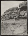
Cross-bedding in Moencopie, capped by Shinarump, Oljato, Utah, 1910. | P0013 Herbert E. Gregory Photograph Collection | P0013n04_16_0540 |
| 158 |
 |
San Francisco Mountain (Photo N-M83a) | P0013 Herbert E. Gregory Photograph Collection | P0013n04_17_0541 |
| 159 |
 |
Structure, Dolores and La Plata, looking west from Oljato, Utah, 1910 (Photo N-M84) | P0013 Herbert E. Gregory Photograph Collection | P0013n04_18_0542 |
| 160 |
 |
Structure, Dolores and La Plata, looking west from Oljato, Utah, 1910 (Photo N-M84) | P0013 Herbert E. Gregory Photograph Collection | P0013n04_18_0542 |
| 161 |
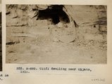 |
Cliff Dwelling near Oljato, Utah (Photo N-M85) | P0013 Herbert E. Gregory Photograph Collection | P0013n04_18_0543 |
| 162 |
 |
Method of trapping coyotes, Oljato, Utah, 1910 (Photo G141) | P0013 Herbert E. Gregory Photograph Collection | P0013n04_19_0544 |
| 163 |
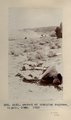 |
Method of trapping coyotes, Oljato, Utah, 1910 (Photo G141) | P0013 Herbert E. Gregory Photograph Collection | P0013n04_19_0544 |
| 164 |
 |
Piute woman with ollas, Oljato, Utah (Photo G142) | P0013 Herbert E. Gregory Photograph Collection | P0013n04_19_0545 |
| 165 |
 |
Indian trading post, John Wetherill, Oljato, Utah, 1910 (Photo G143) | P0013 Herbert E. Gregory Photograph Collection | P0013n04_20_0546 |
| 166 |
 |
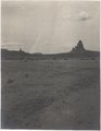
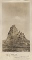
Agathla and Slim (Queen) Rock, Ariz., from S.E. (Photo N-M86) | P0013 Herbert E. Gregory Photograph Collection | P0013n04_20_0547 |
| 167 |
 |
Agathla and Slim (Queen) Rock, Ariz., from S.E. (Photo G144) | P0013 Herbert E. Gregory Photograph Collection | P0013n04_21_0548 |
| 168 |
 |
Agathla and Slim (Queen) Rock, Ariz., from S.E. (Photo G144) | P0013 Herbert E. Gregory Photograph Collection | P0013n04_21_0548 |
| 169 |
 |
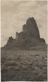
Agathla, volcanic neck, between Chinlee, Ariz. and Oljato, Utah, 1910 (Photo G145) | P0013 Herbert E. Gregory Photograph Collection | P0013n04_21_0549 |
| 170 |
 |
Agathla, volcanic neck, between Chinlee, Ariz. and Oljato, Utah, 1910 (Photo G145) | P0013 Herbert E. Gregory Photograph Collection | P0013n04_21_0549 |
| 171 |
 |
Agathla, volcanic neck, between Chinlee, Ariz. and Oljato, Utah, 1910 (Photo G146) | P0013 Herbert E. Gregory Photograph Collection | P0013n04_22_0550 |
| 172 |
 |
Agathla, volcanic neck, between Chinlee, Ariz. and Oljato, Utah, 1910 (Photo G146) | P0013 Herbert E. Gregory Photograph Collection | P0013n04_22_0550 |
| 173 |
 |
Agathla (John Wetherill photo) | P0013 Herbert E. Gregory Photograph Collection | P0013n04_22verso_0551 |
| 174 |
 |
Agathla, volcanic neck, between Chinlee, Ariz. and Oljato, Utah, 1910 (same as G145, Townsend photo) | P0013 Herbert E. Gregory Photograph Collection | P0013n04_23_0552 |
| 175 |
 |
Cha-ez Kla. (No. 4). Volcanic neck or dike, 2+ mi, south of Agathla Needle, Ariz., 1910 (Photo G147) | P0013 Herbert E. Gregory Photograph Collection | P0013n04_24_0553 |