|
|
Author | Title | Subject | Date | Publication Type |
| 151 |
 |
Schaeffer, Jr. Frederick Ernst | Geology of the Central and Southern Silver Island Mountains Tooele County, Utah and Elko County, Nevada: Georeferenced map files | | 1961-06 | thesis |
| 152 |
 |
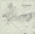
Brox, George Stanley | Plate 1: Geologic map of Northern Bryce Canyon National Park | | 1961-06 | thesis |
| 153 |
 |
Schaeffer, Jr. Frederick Ernst | Plate 1B: Geologic map of the Central and Southern Silver Island Mountains, Box Elder and Tooele Counties, Utah, and Elko County, Nevada (Google Earth map overlay KMZ file) | Thesis and dissertation georeferencing project | 1961-06 | thesis |
| 154 |
|
Groenewold, Bernard Cyrus | Subsurface geology of the Mesozoic formations overlying the Uncompahgre Uplift in Grand County, Utah (Google Earth map overlay KMZ file) | Geology; Utah; Grand County; Stratigraphic; Mesozoic; Thesis and dissertation georeferencing project | 1961-06 | map |
| 155 |
 |
Schaeffer, Frederick Ernst Jr. | Plate 1C: Geologic cross sections of the Central and Southern Silver Island Mountains, Box Elder and Tooele Counties, Utah and Elko County, Nevada | | 1961-06 | thesis |
| 156 |
 |
Schaeffer, Frederick Ernst Jr. | Plate 1B: Geologic map of the Central and Southern Silver Island Mountains, Box Elder and Tooele Counties, Utah, and Elko County, Nevada | | 1961-06 | thesis |
| 157 |
 |
Zimmerman, James T. | Geology of the Cove Creek area Millard County and Beaver County, Utah | Geology; Utah; Cove Creek area; Thesis and dissertation georeferencing project | 1961-06 | thesis |
| 158 |
 |
Schaeffer, Frederick Ernst Jr. | Geology of the Central and Southern silver Island Mountains Tooele County, Utah and Elko County, Nevada-Maps | Geology -- Utah -- Silver Island Mountains | 1961-06 | thesis |
| 159 |
|
Harrill, James Reece | Geology of the Davis Knolls and northern Big Davis Mountain area, Tooele County, Utah: Georeferenced map files | Geology -- Utah -- Tooele County | 1962-08 | thesis |
| 160 |
 |
Harrill, James Reece | Geology of the Davis Knolls and northern Big Davis Mountain area, Tooele County, Utah | Geology -- Utah -- Tooele County; Thesis and dissertation georeferencing project | 1962-08 | thesis |
| 161 |
|
Harrill, James Reece | Geology of the Davis Knolls and northern Big Davis Mountain area, Tooele County, Utah (Google Earth map overlay KMZ file) | Geology -- Utah -- Tooele County; Thesis and dissertation georeferencing project | 1962-08 | map |
| 162 |
|
Neff, Thomas Rodney | Petrology and structure of the little willow series, Wasatch Mountains, Utah: Georeferenced map files | Petrology -- Utah -- Wasatch Mountains | 1962-11 | thesis |
| 163 |
|
Neff, Thomas Rodney | Petrology and structure of the little willow series, Wasatch Mountains, Utah (Google Earth map overlay KMZ file) | Petrology -- Utah -- Wasatch Mountains; Thesis and dissertation georeferencing project | 1962-11 | map |
| 164 |
 |
Neff, Thomas Rodney | Petrology and structure of the little willow series, Wasatch Mountains, Utah | Petrology -- Utah -- Wasatch Mountains; Thesis and dissertation georeferencing project | 1962-11 | thesis |
| 165 |
 |
Neff, Thomas Rodney | Plate 3: Structural map of the Little Willow Series, Wasatch Mountains, Utah | | 1962-11 | thesis |
| 166 |
 |
Neff, Thomas Rodney | Plate 1: Geologic map of the Little Willow Series, Wasatch Mountains, Utah | | 1962-11 | thesis |
| 167 |
 |
Neff, Thomas Rodney | Plate 2: Sections along line A-A' and B-B' | | 1962-11 | thesis |
| 168 |
 |
Neff, Thomas Rodney | Plate 4: Map variations of the Little Willow Series, Wasatch Mountains, Utah | | 1962-11 | thesis |
| 169 |
 |
Neff, Thomas Rodney | Petrology and structure of the Little Willow Series, Wasatch Mountains, Utah-Maps | Petrology -- Utah -- Wasatch Mountains | 1962-11 | thesis |
| 170 |
 |
Murany, Ernest E | Subsurface stratigraphy of the Wasatch Formation of the Uinta Basin, Utah | Stratigraphic geology; Natural gas | 1963-05 | thesis |
| 171 |
|
Vlam, Heber Adolf Arien | Petrology of Lake Bonneville Gravels Salt Lake County, Utah: Georeferenced map files | Petrology; Utah; Salt Lake County; Bonneville; Lake | 1963-05 | thesis |
| 172 |
|
Murany, Ernest E. | Subsurface stratigraphy of the Wasatch Formation of the Uinta Basin, Utah: Georeferenced map files | Stratigraphic geology; Natural gas | 1963-05 | thesis |
| 173 |
|
Vlam, Heber Adolf Arien | Petrology of Lake Bonneville Gravels Salt Lake County, Utah (Google Earth map overlay KMZ file) | Petrology; Utah; Salt Lake County; Bonneville; Lake; Thesis and dissertation georeferencing project | 1963-05 | map |
| 174 |
 |
Vlam, Heber Adolf Arien | Petrology of Lake Bonneville Gravels Salt Lake County, Utah | Petrology; Utah; Salt Lake County; Bonneville; Thesis and dissertation georeferencing project | 1963-05 | thesis |
| 175 |
 |
Kayser, Robert Benham | Sedimentary petrology of the nugget sandstone northern Utah, western Wyoming, and eastern Idaho | Sandstone -- Utah Sandstone -- Wyoming Sandstone -- Idaho | 1964 | thesis |