|
|
Author | Title | Subject | Date | Publication Type |
| 151 |
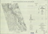 |
Sadeghi, Ali Reza | Structural geology of the Willard Peak Area, North-Central Wasatch Mountains, Utah-Maps | Geology -- Structural -- Utah -- Willard Peak area | 1972-12 | thesis |
| 152 |
 |
Overtoom, Gregory James | Synvolcanic oligocene stress reorientation in Eastern Nevada: evidence from the Golden Gate range | Volcanism -- Nevada -- Lincoln County, Nye County; Faults (Geology) -- Nevada -- Lincoln County,Nye County | 1994-12 | thesis |
| 153 |
 |
Blakey, Ronald Clyde | Geology of the Paria Northwest quadrangle Kane County, Utah-Maps | Geology -- Utah -- Kane County -- Paria Northwest quadrangle | 1970-08 | thesis |
| 154 |
 |
Dalness, William Michael | Parunuweap formation in the vicinity of Zion National Park, Utah-Maps | | 1969-06 | thesis |
| 155 |
 |
Schaeffer, Frederick Ernst Jr. | Geology of the Central and Southern silver Island Mountains Tooele County, Utah and Elko County, Nevada-Maps | Geology -- Utah -- Silver Island Mountains | 1961-06 | thesis |
| 156 |
 |
Maurer, Robert Eugene | Geology of the Cedar Mountains,Tooele County, Utah (Thesis and maps) | Geology; Utah; Tooele County; Geology; Utah; Cedar Mountains; Thesis and dissertation dereferencing project | 1970-06 | thesis |
| 157 |
 |
Johnson, Eric Henry | Plate 2 Topography, resistivity, and chargeability cross-sections along dipole-dipole line 1 on Fumarole Butte | Basalt -- Utah; Geothermal resources -- Utah | 1975-08 | thesis |
| 158 |
 |
Johnson, Eric Henry | Resistivity and induced polarization survey of a basalt flow in a geothermal environment, Western Utah | Basalt -- Utah; Geothermal resources -- Utah | 1975-08 | thesis |
| 159 |
 |
Johnson, Eric Henry | Plate1 Map of Fumarole Butte showing topography, geology, and locations of dipole-dipole profiles and Schlumberger soundings | Basalt -- Utah; Geothermal resources -- Utah | 1975-08 | thesis |
| 160 |
 |
Johnson, Eric Henry | Plate 3 Topography, resistivity, and chargeability cross-sections along dipole-dipole line 2 on Fumarole Butte | Basalt -- Utah; Geothermal resources -- Utah | 1975-08 | thesis |
| 161 |
 |
Harrill, James Reece | Geology of the Davis Knolls and northern Big Davis Mountain area, Tooele County, Utah | Geology -- Utah -- Tooele County; Thesis and dissertation georeferencing project | 1962-08 | thesis |
| 162 |
 |
Stifel, Peter Beekman | Geology of the Terrace and Hogup Mountains, Box Elder County, Utah: Georeferenced map files | Geology -- Utah -- Box Elder County | 1964-06 | thesis |
| 163 |
|
Gross, Larry T. | Stratigraphic analysis of the Mesaverde Group, Uinta Basin, Utah: Georeferenced map files | Geology; Stratigraphic; Cretaceous; Uinta Basin (Utah and Colo.) | 1961-05 | thesis |
| 164 |
|
Vlam, Heber Adolf Arien | Petrology of Lake Bonneville Gravels Salt Lake County, Utah: Georeferenced map files | Petrology; Utah; Salt Lake County; Bonneville; Lake | 1963-05 | thesis |
| 165 |
|
Slentz, Loren William | Tertiary Salt Lake group in the Great Salt Lake Basin: Georeferenced map files | Geology; Stratigraphic; Tertiary; Utah; Great Salt Lake Basin | 1955-07 | thesis |
| 166 |
|
Earll, Fred Nelson | Geology of the Central Mineral Range, Beaver County, Utah: Georeferenced map files | Geology -- Utah -- Mineral Mountains; Beaver County | 1957-08 | thesis |
| 167 |
|
Groenewold, Bernard Cyrus | Subsurface geology of the Mesozoic formations overlying the Uncompahgre Uplift in Grand County, Utah: Georeferenced map files | Geology; Utah; Grand County; Stratigraphic; Mesozoic | 1961-06 | thesis |
| 168 |
|
Anderson, Warren L. | Geology of the northern Silver Island Mountains, Box Elder and Tooele Counties, Utah: Georeferenced maps | Geology; Utah; Silver Island Mountains | 1957-06 | thesis |
| 169 |
|
O'Toole, Walter L. | Geology of the Keetley-Kamas volcanic area: Georeferenced map files | Geology; Utah; Summit County; Wasatch County | 1951 | thesis |
| 170 |
|
Eriksson, Yves | Geology of the upper Ogden Canyon, Weber County, Utah: Georeferenced map files | Geology -- Utah -- Weber County | 1960-06 | thesis |
| 171 |
|
Morris, Elliot Cobia | Geology of the Big Piney area, Summit County, Utah: Georeferenced map files | Geology -- Utah -- Summit County | 1953-06 | thesis |
| 172 |
|
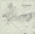
Doelling, Hellmut H. | Geology of the Northern Lakeside Mountains and the Grassy Mountains and vicinity, Tooele and Box Elder Counties, Utah: Georeferenced map files | Geology -- Utah -- Tooele County; Geology -- Utah -- Box Elder County; Geology -- Utah -- Grassy Mountains -- Maps; Geology -- Utah -- Lakeside Mountains -- Maps | 1964-06 | thesis |
| 173 |
 |
Morris, Elliot Cobia | Map 1 Geologic map and sections of Big Piney Area, Utah (Google Earth map overlay KMZ file) | Geology -- Utah -- Summit County | 1953-06 | thesis |
| 174 |
|
Mount, Donald Lee | Plate 3: Geologic map and sections of Wanship-Park City region, Utah (Google Earth map overlay KMZ file) | Geology -- Utah -- Summit County | 1952-06 | thesis |
| 175 |
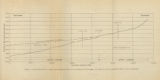 |
Gates, Joseph S. | Figure 4: Longitudinal profile of Middle Canyon showing locations of the profiles across the canyon, the nickpoint, and the hypothetical profile before rejuvenation | Thesis and dissertation georeferencing project | 1960-08 | thesis |