|
|
Title | Date | Type | Setname |
| 151 |
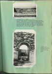 |
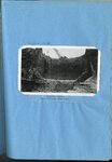
Kessler Canyon barrier spillway : looking down stream from main spillway, Kessler Canyon [and] Detail of rubble-concrete construction | 1923; 1924; 1925; 1926; 1927; 1928; 1929; 1930; 1931; 1932; 1933 | Image/StillImage | uum_map |
| 152 |
 |
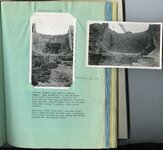
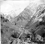
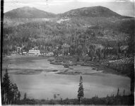
Erosion on Santa Clara Creek is a problem of great concern to the farmers of St. George and Santa Clara | 1923; 1924; 1925; 1926; 1927; 1928; 1929; 1930; 1931; 1932; 1933 | Image/StillImage | uum_map |
| 153 |
 |
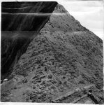
Erosion on Santa Clara Creek : an attempt at control on Santa Clara Creek | 1923; 1924; 1925; 1926; 1927; 1928; 1929; 1930; 1931; 1932; 1933 | Image/StillImage | uum_map |
| 154 |
 |
Chalk Creek before control, looking up stream during period of highwater in spring, when stream was carrying large quantities of gravel [and] Looking up stream across north end of Fillmore barrier, first season of operation | 1923; 1924; 1925; 1926; 1927; 1928; 1929; 1930; 1931; 1932; 1933 | Image/StillImage | uum_map |
| 155 |
 |
Kessler Canyon barrier spillway : Guniting a rubble-concrete wing wall, Kessler Canyon [and] Gasoline driven shovel building the flood barrier, Kessler Canyon | 1923; 1924; 1925; 1926; 1927; 1928; 1929; 1930; 1931; 1932; 1933 | Image/StillImage | uum_map |
| 156 |
 |
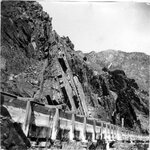
Kessler Canyon barrier spillway : spillway through man barrier, Kessler Canyon [and] The flood stream drops over a circular crest into a stilling pond | 1923; 1924; 1925; 1926; 1927; 1928; 1929; 1930; 1931; 1932; 1933 | Image/StillImage | uum_map |
| 157 |
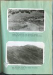 |
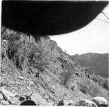
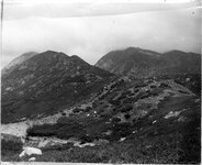
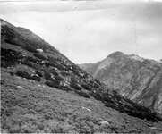
Erosion of foot hills near Bountiful, showing goat herd which grazes over the Bountiful water-shed [and] Near the crest of the Davis County water-shed where floods originate | 1923; 1924; 1925; 1926; 1927; 1928; 1929; 1930; 1931; 1932; 1933 | Image/StillImage | uum_map |
| 158 |
 |
Haights Creek Diversion dam in process of construction | 1923; 1924; 1925; 1926; 1927; 1928; 1929; 1930; 1931; 1932; 1933 | Image/StillImage | uum_map |
| 159 |
 |
Kessler Canyon main spillway structure | 1923; 1924; 1925; 1926; 1927; 1928; 1929; 1930; 1931; 1932; 1933 | Image/StillImage | uum_map |
| 160 |
 |
Butcher Shop, Mine Office and Wasatch Store, Sunnyside | 1920; 1921; 1922; 1923; 1924; 1925; 1926; 1927; 1928; 1929; 1930; 1931; 1932; 1933; 1934; 1935; 1936; 1937; 1938; 1939; 1940 | Image/StillImage | uum_map |
| 161 |
 |
Trip assembly yard Castle Gate Number 2 Mine at Willow Creek | 1912; 1913; 1914; 1915; 1916; 1917; 1918; 1919; 1920; 1921; 1922; 1923; 1924; 1925; 1926; 1927; 1928; 1929; 1930; 1931; 1932; 1933; 1934; 1935; 1936; 1937; 1938; 1939; 1940; 1941; 1942; 1943; 1944; 1945; 1946; 1947; 1948; 1949; 1950 | Image/StillImage | uum_map |
| 162 |
 |
Haulage Portal Castle Gate Number 2 Mine, Bridge over Willow Creek | 1920; 1921; 1922; 1923; 1924; 1925; 1926; 1927; 1928; 1929; 1930 | Image/StillImage | uum_map |
| 163 |
 |
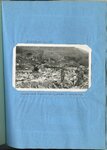
Castle Gate Tipple and townsite | 1920; 1921; 1922; 1923; 1924; 1925; 1926; 1927; 1928; 1929; 1930; 1931; 1932; 1933; 1934; 1935; 1936; 1937; 1938; 1939; 1940 | Image/StillImage | uum_map |
| 164 |
 |
Dip and strike of Cambrian shales, slates and quartzite, Big Cottonwood Canyon | 1910; 1911; 1912; 1913; 1914; 1915; 1916; 1917; 1918; 1919; 1920; 1921; 1922; 1923; 1924; 1925; 1926; 1927; 1928; 1929; 1930; 1931; 1932; 1933; 1934; 1935; 1936; 1937; 1938; 1939; 1940; 1941; 1942; 1943; 1944; 1945 | Image/StillImage | uum_map |
| 165 |
 |
Stratification of Cambrian quartzite and shales, Big Cottonwood Canyon | 1910; 1911; 1912; 1913; 1914; 1915; 1916; 1917; 1918; 1919; 1920; 1921; 1922; 1923; 1924; 1925; 1926; 1927; 1928; 1929; 1930; 1931; 1932; 1933; 1934; 1935; 1936; 1937; 1938; 1939; 1940; 1941; 1942; 1943; 1944; 1945 | Image/StillImage | uum_map |
| 166 |
 |
Stratified shales and slates, Big Cottonwood Canyon [02] | 1910; 1911; 1912; 1913; 1914; 1915; 1916; 1917; 1918; 1919; 1920; 1921; 1922; 1923; 1924; 1925; 1926; 1927; 1928; 1929; 1930; 1931; 1932; 1933; 1934; 1935; 1936; 1937; 1938; 1939; 1940; 1941; 1942; 1943; 1944; 1945 | Image/StillImage | uum_map |
| 167 |
 |
Stratified slates showing dip, above flume in Big Cottonwood | 1910; 1911; 1912; 1913; 1914; 1915; 1916; 1917; 1918; 1919; 1920; 1921; 1922; 1923; 1924; 1925; 1926; 1927; 1928; 1929; 1930; 1931; 1932; 1933; 1934; 1935; 1936; 1937; 1938; 1939; 1940; 1941; 1942; 1943; 1944; 1945 | Image/StillImage | uum_map |
| 168 |
 |
Clayton Peak, Brighton | 1910; 1911; 1912; 1913; 1914; 1915; 1916; 1917; 1918; 1919; 1920; 1921; 1922; 1923; 1924; 1925; 1926; 1927; 1928; 1929; 1930; 1931; 1932; 1933; 1934; 1935; 1936; 1937; 1938; 1939; 1940; 1941; 1942; 1943; 1944; 1945 | Image/StillImage | uum_map |
| 169 |
 |
Cambrian slates at bottom of Big Cottonwood Canyon | 1910; 1911; 1912; 1913; 1914; 1915; 1916; 1917; 1918; 1919; 1920; 1921; 1922; 1923; 1924; 1925; 1926; 1927; 1928; 1929; 1930; 1931; 1932; 1933; 1934; 1935; 1936; 1937; 1938; 1939; 1940; 1941; 1942; 1943; 1944; 1945 | Image/StillImage | uum_map |
| 170 |
 |
Stratified shales and slates, Big Cottonwood Canyon [01] | 1910; 1911; 1912; 1913; 1914; 1915; 1916; 1917; 1918; 1919; 1920; 1921; 1922; 1923; 1924; 1925; 1926; 1927; 1928; 1929; 1930; 1931; 1932; 1933; 1934; 1935; 1936; 1937; 1938; 1939; 1940; 1941; 1942; 1943; 1944; 1945 | Image/StillImage | uum_map |
| 171 |
 |
Morainic mass extending across Little Cottonwood Canyon | 1910; 1911; 1912; 1913; 1914; 1915; 1916; 1917; 1918; 1919; 1920; 1921; 1922; 1923; 1924; 1925; 1926; 1927; 1928; 1929; 1930; 1931; 1932; 1933; 1934; 1935; 1936; 1937; 1938; 1939; 1940; 1941; 1942; 1943; 1944; 1945 | Image/StillImage | uum_map |
| 172 |
 |
Fault scarp crossing south moraine of Little Cottonwood Canyon | 1910; 1911; 1912; 1913; 1914; 1915; 1916; 1917; 1918; 1919; 1920; 1921; 1922; 1923; 1924; 1925; 1926; 1927; 1928; 1929; 1930; 1931; 1932; 1933; 1934; 1935; 1936; 1937; 1938; 1939; 1940; 1941; 1942; 1943; 1944; 1945 | Image/StillImage | uum_map |
| 173 |
 |
Perched, granite boulders on quartzite formation, Little Cottonwood Canyon | 1910; 1911; 1912; 1913; 1914; 1915; 1916; 1917; 1918; 1919; 1920; 1921; 1922; 1923; 1924; 1925; 1926; 1927; 1928; 1929; 1930; 1931; 1932; 1933; 1934; 1935; 1936; 1937; 1938; 1939; 1940; 1941; 1942; 1943; 1944; 1945 | Image/StillImage | uum_map |
| 174 |
 |
Bonneville and intermediate shore lines near mouth of Dry Canyon | 1910; 1911; 1912; 1913; 1914; 1915; 1916; 1917; 1918; 1919; 1920; 1921; 1922; 1923; 1924; 1925; 1926; 1927; 1928; 1929; 1930; 1931; 1932; 1933; 1934; 1935; 1936; 1937; 1938; 1939; 1940; 1941; 1942; 1943; 1944; 1945 | Image/StillImage | uum_map |
| 175 |
 |
Contact between archaean quartzite and granite, south side of Little Cottonwood Canyon | 1910; 1911; 1912; 1913; 1914; 1915; 1916; 1917; 1918; 1919; 1920; 1921; 1922; 1923; 1924; 1925; 1926; 1927; 1928; 1929; 1930; 1931; 1932; 1933; 1934; 1935; 1936; 1937; 1938; 1939; 1940; 1941; 1942; 1943; 1944; 1945 | Image/StillImage | uum_map |