Home
Browse
Ask Us
Chat
Harmful Language Statement
Log in
Advanced Search
Year
1872
1873
1874
1875
1876
1877
1878
1879
1880
1881
1882
1883
1884
1885
1886
1887
1888
1889
1890
1891
1892
1893
1894
1895
1896
1897
1898
1899
1900
1901
1902
1903
1904
1905
1906
1907
1908
1909
1910
1911
1912
1913
1914
1915
1916
1917
1918
1919
1920
1921
1922
1923
1924
1925
1926
1927
1928
1929
1930
1931
1932
1933
1934
1935
1936
1937
1938
1939
1940
1941
1942
1943
1944
1945
1946
1947
1948
1949
1950
1951
1952
1953
1954
1955
1956
1957
1958
1959
1960
1961
1962
1963
1964
1965
1966
1967
1968
1969
1970
1971
1972
1973
1974
1975
1976
1977
1978
1979
1980
1981
1982
1983
1984
1985
1986
1987
1988
1989
1990
1991
1992
1993
TO
1872
1873
1874
1875
1876
1877
1878
1879
1880
1881
1882
1883
1884
1885
1886
1887
1888
1889
1890
1891
1892
1893
1894
1895
1896
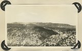
1897
1898
1899
1900
1901
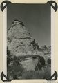
1902
1903
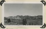
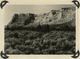
1904
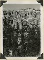
1905
1906
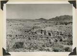
1907
1908
1909
1910
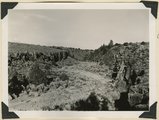
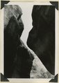
1911
1912
1913
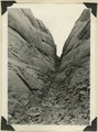
1914
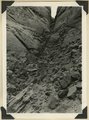
1915
1916
1917
1918
1919
1920
1921
1922
1923
1924
1925
1926
1927
1928
1929
1930
1931
1932
1933
1934
1935
1936
1937
1938
1939
1940
1941
1942
1943
1944
1945
1946
1947
1948
1949
1950
1951
1952
1953
1954
1955
1956
1957
1958
1959
1960
1961
1962
1963
1964
1965
1966
1967
1968
1969
1970
1971
1972
1973
1974
1975
1976
1977
1978
1979
1980
1981
1982
1983
1984
1985
1986
1987
1988
1989
1990
1991
1992
1993
Type
Image
3,521
Image/StillImage
143
Format
image/jpeg
3,594
application/pdf
70
Collection
Photo Archives
3,521
UAIDA Main Collection
143
Filters:
Collection Name:
"Herbert E. Gregory"
151
-
175
of
3,664
<
2
3
4
5
6
7
8
9
10
11
>
Gallery view
Number of results to display per page
10
25
50
100
200
Sort by Relevance
Sort by Title A-Z
Sort by Title Z-A
Sort by Date Ascending
Sort by Date Descending
Sort by Last Modified Ascending
Sort by Last Modified Descending
Title
Date
Type
Setname
151
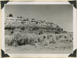
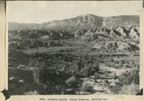
Sheep Flat. Broad treeless highland crossed by shallow stream runways between Coalpits Wash and Pinion Ridge. A little modified part of the eastward dipping (right) surface of Markagunt Plateau. Garfield County, UT, 1944
1944
Image
uum_map
152
Shinarump Conglomerate at Pioneer Gap. Kane County, UT, 1944
1944
Image
uum_map
153
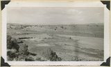
South Fork of Sevier River below mouth of Asay Creek. Garfield County, UT, 1944
1944
Image
uum_map
154
South sink of Duck Creek. Entire stream enters hole in Wasatch limestone. Garfield County, UT. 1943
1943
Image
uum_map
155
Surface of Markagunt Plateau looking west from the head of Deedy Hollow. Coated with gravel from decomposed igneous conglomerates and rhyolite. Garfield County, UT. 1943
1943
Image
uum_map
156
Surface of Navajo sandstone between Escalante Canyon and Kaiparowits Plateau. Butte of Upper Jurassic rocks. Near head of Davis Creek. Garfield County, UT, 1944
1944
Image
uum_map
157
Surface of Navajo sandstone trenched by Escalante Canyon (right middle). Aquarius Plateau on skyline. Garfield County, UT, 1944
1944
Image
uum_map
158
Surface of recent basalt flow north of Duck Creek sinks. Garfield County, UT. 1943
1943
Image
uum_map
159
Timpoweap member of the Moenkopi formation. Kaibab at base, upstream. East rim of the Kaibab Plateau near the UT-AZ line. Coconino County, AZ, 1944
1944
Image
uum_map
160
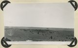
Treeless slope developed on pyroclastic and igneous rocks typical of areas west of Panguitch Creek. Garfield County, UT, 1944
1944
Image
uum_map
161
Typical outcrop of conglomerate near base of Brian Head formation, Castle Creek. Garfield County, UT, 1944
1944
Image
uum_map
162
Upper Brian Head formation near the mouth of Deedy Hollow. Garfield County, UT. 1943
1943
Image
uum_map
163
Vermillion Cliffs. Chinle formation. Petrified Forest member (foreground and basalt slopes) and upper sandstone. Flag Point, Kane County, UT. 1944
1944
Image
uum_map
164
Vermillion Cliffs. Chinle formation. Petrified Forest member eroded into bedlands; upper sandstone capped by outliers of Wingate. Lower Road Creek. Kane County, UT, 1944
1944
Image
uum_map
165
View looking east from Kaibab Plateau across House Rock Valley (invisible) to the Coxcomb Navajo sandstone in the East Kaibab monocline. Timpoweap member of the Moenkopi forms walls of local gulch. Kane County, UT, 1944
1944
Image
uum_map
166
View looking north across Casto Canyon toward the face of the Sevier Plateau. Slope of Brian Head formation beneath gravels (foreground) and in steep white slope ( middle distance) is capped by igneous conglomerates and lavas. Garfield County, UT. 1943
1943
Image
uum_map
167
View looking northeast across Antimony Canyon. Cretaceous strata (foreground and middle distance) below igneous conglomerate and acidic lavas that form the surface of Aquarius Plateau. Garfield County, UT, 1943
1943
Image
uum_map
168
Wagon Wheel Gap, Rock Creek Canyon. Walls of basalt, 120 feet high. Garfield County, UT, 1944
1944
Image
uum_map
169
Wasatch limestones, overlying Cretaceous; southern limit of Pink Cliffs. Dairy Canyon. Kane County, UT, 1944
1944
Image
uum_map
170
West entrance to Hole-in-the-Rock, an eroded fault crack in Navajo sandstone on the west rim of Glen Canyon. A feature of the abandoned Escalante-Bluff Road. Garfield County, UT, 1944
1944
Image
uum_map
171
West entrance to Hole-in-the-Rock, an eroded fault crack in Navajo sandstone on the west rim of Glen Canyon. A feature of the abandoned Escalante-Bluff Road. Garfield County, UT, 1944
1944
Image
uum_map
172
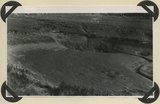
West wall of Seaman Wash
1944
Image
uum_map
173
Willow Creek branch of Escalante Canyon. In sinking its channel the creek has been guided by joints in Navajo sandstone. Garfield County, UT, 1944
1944
Image
uum_map
174
Willow Creek branch of Escalante Canyon. Entrance to 'the Narrows,' 400 feet long and 5-6 feet wide; perched log marks high water stage. Garfield County, UT, 1944
1944
Image
uum_map
175
Wingate sandstone, includes bed of limestone. Wall of Flood Canyon. Kane County, UT. 1943
1943
Image
uum_map
151
-
175
of
3,664
<
2
3
4
5
6
7
8
9
10
11
>