|
|
Title | Collection Number And Name | Photo Number |
| 151 |
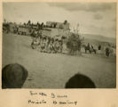 |
Snake dance, priests dancing | P0013 Herbert E. Gregory Photograph Collection | P0013n01_11_025 |
| 152 |
 |
Snake dance, priests in line | P0013 Herbert E. Gregory Photograph Collection | P0013n01_11_024 |
| 153 |
 |
Barohoini Natural Bridge, 10+ mi. northwest of Navajo Mt., Utah in LaPlata strata, 1910. Looking down stream northwest from distance of 1+ mi. (Photo G176) | P0013 Herbert E. Gregory Photograph Collection | P0013n04_57_0604 |
| 154 |
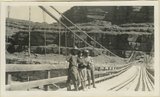 |
Goodridge Bridge. Edna Hope Gregory, Baker, McKnight. San Juan County, UT, 1927 | P0013 Herbert E. Gregory Photograph Collection | P0013n09_064_1842 |
| 155 |
 |
Bridal couple, Lower Oraibi Wash. 1909 | P0013 Herbert E. Gregory Photograph Collection | P0013n03_19_0397 |
| 156 |
 |
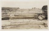
Cliff, LaPlata on Dolores at mouth of Sagy at Sosi canyon, AZ. 1910 (Photo G166) | P0013 Herbert E. Gregory Photograph Collection | P0013n04_40_0577 |
| 157 |
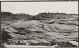 |
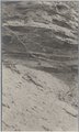
Cross-bedding, Moencopie (?) strata, 6± mi. northeast of Agathla Needle, Ariz., 1910 (Photo G157) | P0013 Herbert E. Gregory Photograph Collection | P0013n04_32_0569 |
| 158 |
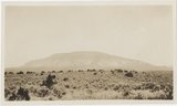 |
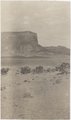
Distant (10 mi.) view of Navaho Mt., southeast (Photo G368) | P0013 Herbert E. Gregory Photograph Collection | P0013n06_045_0917 |
| 159 |
 |
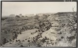
Dolores Badlands 1 1/2 mile west of Nashlini. (I-5 & I-7 in film book just like this) (Photo N-M135) | P0013 Herbert E. Gregory Photograph Collection | P0013n06_003_0827 |
| 160 |
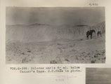 |
Dolores marls 8± mi. below Tanner's Spgs. E.C.Case in photo (Photo G398) | P0013 Herbert E. Gregory Photograph Collection | P0013n06_064_0954 |
| 161 |
 |
Dunes filling Reservoir Canyon, Tuba (IV-8 in film book is also like this) (Photo G441) | P0013 Herbert E. Gregory Photograph Collection | P0013n06_093_1014 |
| 162 |
 |
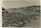
Erosion column. Block of Dakota resting on LaPlata, Southeast of Gallup on west line of Wingate reservation. VII, 3. 1911 (Photo G189) | P0013 Herbert E. Gregory Photograph Collection | P0013n05_01_0662 |
| 163 |
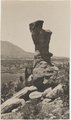 |
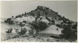
Erosion pillar, McElmo valley, 15± miles west of Cortez, Colorado. 1910 | P0013 Herbert E. Gregory Photograph Collection | P0013n04_01_0511 |
| 164 |
 |
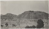
General view of upper Moencopie strata, looking northeast toward Monument Pass. Taken from a point 8± mi. northeast of Agathla Needle, Ariz., 1910 (Photo G158) | P0013 Herbert E. Gregory Photograph Collection | P0013n04_32_0560A |
| 165 |
 |
Grand Falls, Little Colorado (Photo N-M175) | P0013 Herbert E. Gregory Photograph Collection | P0013n06_079_0986 |
| 166 |
 |
Grand Falls, panorama (Photos G415) | P0013 Herbert E. Gregory Photograph Collection | P0013n06_078a_0982 |
| 167 |
 |
Grand Falls, panorama (Photos G416) | P0013 Herbert E. Gregory Photograph Collection | P0013n06_078a_0983 |
| 168 |
 |
Gypsum in Permian. 2± mi. east of Holbrook (Photo G402) | P0013 Herbert E. Gregory Photograph Collection | P0013n06_067_0961 |
| 169 |
 |
Joints in LaPlata sandstone. Head of Pahute canyon, UT. 1910 (Photo G183) | P0013 Herbert E. Gregory Photograph Collection | P0013n04_62_0622 |
| 170 |
 |
Kaibab limestone (lower wall,left, breccia (marks unconformable contact), and basal Moenkopi limestone and shales. Mouth of Kaibab Gulch. Kane County, UT, 1944 | P0013 Herbert E. Gregory Photograph Collection | P0013n12_047-048_2899 |
| 171 |
 |
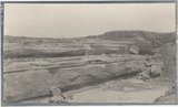
McElmo strata, Holly's ranch, McElmo valley, Colorado, 33± miles west of Cortez, Colorado. 1910 (Photo G-125) | P0013 Herbert E. Gregory Photograph Collection | P0013n04_03_0515 |
| 172 |
 |
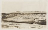
McElmo strata, north bank of San Juan River, 10± mi. below Aneth, Utah, 1910 (Photo G129) | P0013 Herbert E. Gregory Photograph Collection | P0013n04_06_0521 |
| 173 |
 |
Moenkopi formation: Shnabkaib member (lower part), upper red sandstone (upper middle), Shinarump conglomerate (top). East side of Seamans Wash, Kane County, UT. 1943 | P0013 Herbert E. Gregory Photograph Collection | P0013n12_027_2877D |
| 174 |
 |
Monocline, LaPlata over Dolores east face of Skeleton Mesa, 15± mi. north of Marsh Pass, Ariz., 1910 (Photo G154) | P0013 Herbert E. Gregory Photograph Collection | P0013n04_30_0566 |
| 175 |
 |
Mud cracks, McElmos valley, Colorado. 1910 (Photo G-122) | P0013 Herbert E. Gregory Photograph Collection | P0013n04_01_0512 |