Home
Browse
Ask Us
Chat
Harmful Language Statement
Log in
Photo Archives
Advanced Search
About
Over 70,000 photos covering a variety of topics from Marriott Library Special Collections
Year
1872
1873
1874
1875
1876
1877
1878
1879
1880
1881
1882
1883
1884
1885
1886
1887
1888
1889
1890
1891
1892
1893
1894
1895
1896
1897
1898
1899
1900
1901
1902
1903
1904
1905
1906
1907
1908
1909
1910
1911
1912
1913
1914
1915
1916
1917
1918
1919
1920
1921
1922
1923
1924
1925
1926
1927
1928
1929
1930
1931
1932
1933
1934
1935
1936
1937
1938
1939
1940
1941
1942
1943
1944
1945
1946
1947
1948
1949
1950
1951
1952
1953
1954
1955
1956
1957
1958
1959
1960
1961
1962
1963
1964
1965
1966
1967
1968
1969
1970
1971
1972
1973
1974
1975
1976
1977
1978
1979
1980
1981
1982
1983
1984
1985
1986
1987
1988
1989
1990
1991
1992
1993
TO
1872
1873
1874
1875
1876
1877
1878
1879
1880
1881
1882
1883
1884
1885
1886
1887
1888
1889
1890
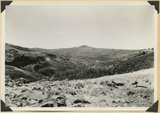
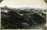
1891
1892
1893
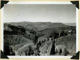
1894
1895
1896
1897
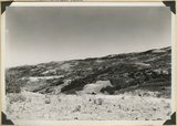
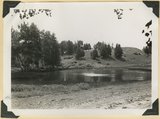
1898
1899
1900
1901
1902
1903
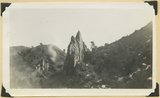
1904
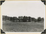
1905
1906
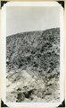
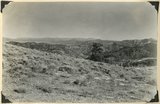
1907
1908
1909
1910
1911
1912
1913
1914
1915
1916
1917
1918
1919
1920
1921
1922
1923
1924
1925
1926
1927
1928
1929
1930
1931
1932
1933
1934
1935
1936
1937
1938
1939
1940
1941
1942
1943
1944
1945
1946
1947
1948
1949
1950
1951
1952
1953
1954
1955
1956
1957
1958
1959
1960
1961
1962
1963
1964
1965
1966
1967
1968
1969
1970
1971
1972
1973
1974
1975
1976
1977
1978
1979
1980
1981
1982
1983
1984
1985
1986
1987
1988
1989
1990
1991
1992
1993
Type
Image
3,451
Format
image/jpeg
3,451
Collection Name
Herbert E. Gregory
3,451
Filters:
Collection Name:
"Herbert E. Gregory"
Collection:
"uum_map"
Format:
image
Setname:
!(ir* OR ehsl*)
151
-
175
of
3,451
<
2
3
4
5
6
7
8
9
10
11
>
Gallery view
Number of results to display per page
10
25
50
100
200
Sort by Relevance
Sort by Title A-Z
Sort by Title Z-A
Sort by Date Ascending
Sort by Date Descending
Sort by Last Modified Ascending
Sort by Last Modified Descending
Sort by Photo Number
Title
Collection Number And Name
Photo Number
151
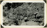
Moenkopi beds upturned in the Kanarra fold and broken by a fault. Lawrence Canyon, Iron County, UT, 1942
P0013 Herbert E. Gregory Photograph Collection
P0013n11_197_2845
152
Moenkopi formation (Shnabkaib and upper red members), Shinarump conglomerate, and Chinle formation, all tilted steeply eastward (right). Gulch near the mouth of Coal Canyon, Iron County, UT, 1942
P0013 Herbert E. Gregory Photograph Collection
P0013n11_182_2817
153
Panorama. Surface of Kolob Terrace near the head of Kolob Creek. Iron County, UT
P0013 Herbert E. Gregory Photograph Collection
P0013n11_173_2800
154
Panorama. Surface of Kolob Terrace near the head of Kolob Creek. Iron County, UT
P0013 Herbert E. Gregory Photograph Collection
P0013n11_172_2799
155
Piute Highlands. Glacial lake and moraine, Moseman (Dry Lakes) Valley. Iron County, UT, 1942
P0013 Herbert E. Gregory Photograph Collection
P0013n11_193_2837
156
Piute Highlands. View looking north from near the base of Eagle Peak across branches of Summit Creek. Parowan Creek to snow capped Tushar Mountains (skyline); rhyolite and Cretaceous in the foreground; Cretaceous, Tertiary, and lavas beyond. Iron County, UT, 1942
P0013 Herbert E. Gregory Photograph Collection
P0013n11_192_2836
157
Piute Highlands. View looking northeast across Parowan and Benson Canyons from base of Applegate Ridge. Rim of Markagunt Plateau (middle skyline); Knob and ridges of Wasatch (middle distance); rhyolite foreground. Iron County, UT. 1942
P0013 Herbert E. Gregory Photograph Collection
P0013n11_191_2833
158
Piute Highlands. View looking northeast across Parowan and Benson Canyons from base of Applegate Ridge. Rim of Markagunt Plateau (middle skyline); Knob and ridges of Wasatch (middle distance); rhyolite foreground. Iron County, UT. 1942
P0013 Herbert E. Gregory Photograph Collection
P0013n11_191_2834
159
Piute Highlands. View looking south from Applegate Ridge across upper Summit Creek. Wasatch in Sugar Loaf Peak (upper left); rhyolite on Summit ridge, middle skyline; Cretaceous (foreground). Iron County, UT, 1942
P0013 Herbert E. Gregory Photograph Collection
P0013n11_192_2835
160
Pond confined by a glacial moraine. Dry Lakes road, Iron County, UT, 1942
P0013 Herbert E. Gregory Photograph Collection
P0013n11_176_2806
161
Recent trenching of valley fill of stratified sands and clay, upper part of Spring Creek Canyon, Iron County, UT, 1942
P0013 Herbert E. Gregory Photograph Collection
P0013n11_175_2804
162
Recent trenching of valley fill of stratified sands and clay, upper part of Spring Creek Canyon, Iron County, UT, 1942
P0013 Herbert E. Gregory Photograph Collection
P0013n11_174_2803
163
Same as 2841, between Murie and Kanarra Creeks. Jurassic and younger strata (background)
P0013 Herbert E. Gregory Photograph Collection
P0013n11_196_2842
164
Sevier fault, mouth of Red Canyon. Wasatch right), basalt (left and top). Garfield County, UT. 1942
P0013 Herbert E. Gregory Photograph Collection
P0013n11_186_2824
165
Shnabkaib member of the Moenkopi formation, chiefly gypsiferous beds, tilted in the Kanarra fold. Branch of Shurtz Creek, Iron County, UT. 1942
P0013 Herbert E. Gregory Photograph Collection
P0013n11_182_2818
166
Shurtz Creek alcove. Pyramids of upturned Navajo sandstone (center; Triassic below; upper Jurassic Cretaceous and basalt above. Strata involved in the Kanarra fold. Iron County, UT
P0013 Herbert E. Gregory Photograph Collection
P0013n11_189_2830ABCD
167
Sidney Valley near head of Castle Creek. Ponds and kame-like accumulation resulting from glaciation. Iron County, UT
P0013 Herbert E. Gregory Photograph Collection
P0013n11_171_2796
168
Sidney Valley near head of Castle Creek. Ponds and kame-like accumulation resulting from glaciation. Iron County, UT
P0013 Herbert E. Gregory Photograph Collection
P0013n11_171_2797
169
Sugar loaf on outlier of Markagunt Plateau on divide between Parowan and Coal Creek drainage areas. Iron County
P0013 Herbert E. Gregory Photograph Collection
P0013n11_169_2792
170
Summit Ridge. Pond supplied chiefly by melting snow. Iron County
P0013 Herbert E. Gregory Photograph Collection
P0013n11_168_2790
171
Summit Ridge. Pond supplied chiefly by melting snow. Iron County
P0013 Herbert E. Gregory Photograph Collection
P0013n11_168_2791
172
Summit Ridge. Undissected highland 9000 feet near head of Summit Canyon, Iron County
P0013 Herbert E. Gregory Photograph Collection
P0013n11_167_2789
173
Summit Ridge. View looking south across Braffitts Canyon. Iron County, UT
P0013 Herbert E. Gregory Photograph Collection
P0013n11_167_2788
174
Surface of Kolob Terrace developed on Cretaceous strata. Three Knolls (basalt) on skyline. Iron County, UT, 1942
P0013 Herbert E. Gregory Photograph Collection
P0013n11_187_2826
175
Surface of Kolob Terrace near head of Crystal Creek. Developed on Tropic shale
P0013 Herbert E. Gregory Photograph Collection
P0013n11_172_2798
151
-
175
of
3,451
<
2
3
4
5
6
7
8
9
10
11
>