|
|
Title | Collection Number And Name | Photo Number |
| 151 |
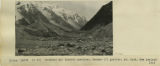 |
Terminal and lateral moraines, Hooker(?) glacier, Mt. Cook, New Zealand, 1916 | P0013 Herbert E. Gregory Photograph Collection | P0013n13_088_9-3130 |
| 152 |
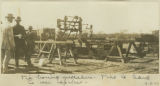 |
Tie boring machine. Ties is hard to use spikes | P0013 Herbert E. Gregory Photograph Collection | P0013n13_111_9-3199 |
| 153 |
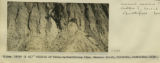 |
Tillite of Permo-Carboniferous time, Bacchus Marsh, Victoria, Australia, 1916 | P0013 Herbert E. Gregory Photograph Collection | P0013n13_096_9-3154 |
| 154 |
 |
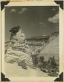
Tilted block broken from Sevier fault, Navajo capped by Carmel. Orderville, Kane County, Utah, 1937. | P0013 Herbert E. Gregory Photograph Collection | P0013n10_198_2442 |
| 155 |
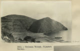 |
Titicaca Island. Hijadero Valley. | P0013 Herbert E. Gregory Photograph Collection | P0013n13_042_9-3028 |
| 156 |
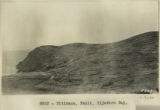 |
Titicaca. Fault. Hijadero Bay. | P0013 Herbert E. Gregory Photograph Collection | P0013n13_043_9-3030 |
| 157 |
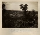 |
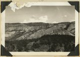
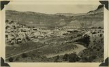
Todilto park looking northwest from east rim. Mrs. Gregory, photo. 1911 (Photo N-M116) | P0013 Herbert E. Gregory Photograph Collection | P0013n05_24_0709 |
| 158 |
 |
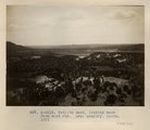
Todilto park, looking south. Defiance Mesas in skyline. Heald, photo. 1911 (Photo N-M117) | P0013 Herbert E. Gregory Photograph Collection | P0013n05_25_0710 |
| 159 |
 |
Todilto park, looking west from east rim. Mrs. Gregory, photo. 1911 (Photo N-M115) | P0013 Herbert E. Gregory Photograph Collection | P0013n05_23_0708 |
| 160 |
 |
Top of Carrizo Mt. Dakota sandstone broken up by frost on ridge NE of Pastora Peak | P0013 Herbert E. Gregory Photograph Collection | P0013n07_010_1049 |
| 161 |
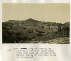 |
Top of Carrizo Mt. Looking N 30° E at Laden Peak from east base of Pastora Peak. Mature valley of Des-chee Creek in foreground | P0013 Herbert E. Gregory Photograph Collection | P0013n07_010_1048 |
| 162 |
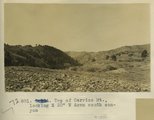 |
Top of Carrizo Mt. Looking S 30° W down south canyon | P0013 Herbert E. Gregory Photograph Collection | P0013n07_011_1050 |
| 163 |
 |
Top of low granite dome rising slightly above desert surface at Wynbring, South Australia, 1916 | P0013 Herbert E. Gregory Photograph Collection | P0013n13_113_9-3204 |
| 164 |
 |
Top of Lukachukai Mts., looking at Roof Butte from the southwest | P0013 Herbert E. Gregory Photograph Collection | P0013n07_015_1059 |
| 165 |
 |
Tower Butte and natural bridge in the Devils Garden, Entrada sandstone, south flank of the Salt Valley anticline, 15± miles west of Moab, Grand County, Utah, 1934. | P0013 Herbert E. Gregory Photograph Collection | P0013n10_216_2478 |
| 166 |
 |
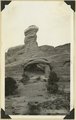
Tower of Navajo sandstone capped by iron concretion along highway near east Checking Station, Zion National Park, Utah, 1936. | P0013 Herbert E. Gregory Photograph Collection | P0013n10_199_2446 |
| 167 |
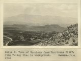 |
Town of Hurricane from Hurricane Cliff. Pine Valley Mountains in background. UT. 1922 | P0013 Herbert E. Gregory Photograph Collection | P0013n08_163_1631 |
| 168 |
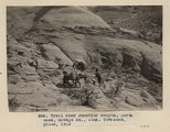 |
Trail near Junction canyon, north base, Navajo Mt., Utah (Townsend photo, 1909) | P0013 Herbert E. Gregory Photograph Collection | P0013n04_54_0596 |
| 169 |
 |
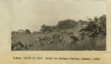
Trail to Waimanu Valley, Hawaii, 1926 [1] | P0013 Herbert E. Gregory Photograph Collection | P0013n13_131_9-3256 |
| 170 |
 |
Trail to Waimanu Valley, Hawaii, 1926 [2] | P0013 Herbert E. Gregory Photograph Collection | P0013n13_131_9-3257 |
| 171 |
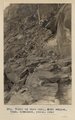 |
Trail up west wall, Noki Canyon, Utah (Townsend photo), 1910. | P0013 Herbert E. Gregory Photograph Collection | P0013n04_44_0582 |
| 172 |
 |
Triassic formations at Paria. Foreground, Moenkopi along road (dark) and Shinarump (light). Butte: Chinle (banded) capped with Wingate sandstone, Kane County, Utah, 1937. | P0013 Herbert E. Gregory Photograph Collection | P0013n10_194_2434 |
| 173 |
 |
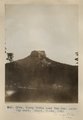
Tse-na-kahn (Round Rock), from southeast. New Mexico. Heald, photo. 1911 (Photo N-M128) | P0013 Herbert E. Gregory Photograph Collection | P0013n05_74_0793 |
| 174 |
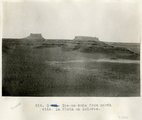 |
Tse-na-kahn from north side. La Plata on Dolores. | P0013 Herbert E. Gregory Photograph Collection | P0013n07_021_1066 |
| 175 |
 |
Tubby Butte near Tsa-lee. Looking east. Heald, photo, 1911 (Photo G296) | P0013 Herbert E. Gregory Photograph Collection | P0013n05_82_0807 |