|
|
Author | Title | Subject | Date | Publication Type |
| 126 |
 |
Condie, Kent C. | Petrogeneis of the Mineral Range Pluton, Southwestern Utah | Petrology -- Utah -- Beaver County; Millard County; Geology -- Utah -- Beaver County; Millard County; Mineral Range (Utah) | 1960-06 | thesis |
| 127 |
 |
Condie, Kent C. | Map 1 Geologic map of the Mineral Range, Utah (Google Earth map overlay KMZ file) | Petrology -- Utah -- Beaver County; Millard County; Geology -- Utah -- Beaver County; Millard County; Mineral Range (Utah); Thesis and dissertation georeferencing project | 1960-06 | thesis |
| 128 |
|
Eriksson, Yves | Map 1 Geology of the upper Ogden Canyon, Weber County, Utah (Google Earth map overlay KMZ file) | Geology -- Utah -- Weber County; Thesis and dissertation georeferencing project | 1960-06 | thesis |
| 129 |
 |
Gates, Joseph S. | Hydrology of middle Canyon, Oquirrh Mountains, Tooele County, Utah | Geology -- Utah -- Oquirrh Mountains; Groundwater -- Utah; Thesis and dissertation georeferencing project | 1960-08 | thesis |
| 130 |
|
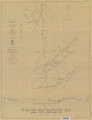
Blue, Donald McCoy | Plate 1: Lucin mining district and vicinity, Northern Pilot Range, Box Elder County, Utah - Elko County, Nevada (Google Earth map overlay KMZ file) | Thesis and dissertation georeferencing project | 1960-08 | thesis |
| 131 |
 |
Blue, Donald McCoy | Geology and ore deposits of the lucin mining district, Box Elder County, Utah, and Elko County, Nevada | Geology -- Utah ; Geology -- Nevada ; Ore deposits -- Utah ; Ore deposits -- Nevada | 1960-08 | thesis |
| 132 |
 |
Blue, Donald McCoy | Geology and ore deposits of the lucin mining district, Box Elder County, Utah, and Elko County, Nevada-Maps | | 1960-08 | thesis |
| 133 |
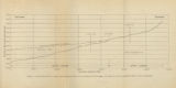 |
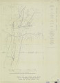
Gates, Joseph S. | Figure 4: Longitudinal profile of Middle Canyon showing locations of the profiles across the canyon, the nickpoint, and the hypothetical profile before rejuvenation | Thesis and dissertation georeferencing project | 1960-08 | thesis |
| 134 |
 |
Blue, Donald McCoy | Geology and ore deposits of the Lucin Mining District, Box Elder County, Utah and Elko County, Nevada: Georeferenced map files | | 1960-08 | thesis |
| 135 |
|
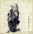
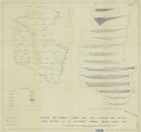
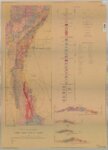
Rodriguez, Enrique Levy | Plate 1: Geologic map and vertical cross section of the Sulphurdale sulphur deposits, Beaver and Millard Counties, Utah (Google Earth map overlay KMZ file) | Geology, Economic -- Utah -- Sulphurdale; Mines and mineral resources -- Utah -- Sulphurdale; Sulphur mines and mining -- Utah -- Sulphurdale; Thesis and dissertation georeferencing project | 1960-08 | thesis |
| 136 |
 |
Rodriguez, Enrique Levy | Plate 3: Detailed geologic and vertical cross section map of the Prince Albert Orebody, Mariposa and Queen Victoria Prospect Pits, Millard County, Utah | | 1960-08 | thesis |
| 137 |
 |
Rodriguez, Enrique Levy | Plate 4: Detailed map showing diamond drill hole locations and vertical cross sections of the Sulphurdale Orebody, Beaver County, Utah | | 1960-08 | thesis |
| 138 |
 |
Rodriguez, Enrique Levy | Plate 2: Detailed geologic and vertical cross sections map of the Excelsior Orebody and New York Prospect Pit, Millard County, Utah | | 1960-08 | thesis |
| 139 |
 |
Rodriguez, Enrique Levy | Plate 1: Geologic map and vertical cross section of the Sulphurdale sulphur deposits, Beaver and Millard Counties, Utah | | 1960-08 | thesis |
| 140 |
 |
Brox, George Stanley | The geology and erosional development Northern Bryce Canyon National Park | Geology; Utah; Bryce Canyon National Park Erosion; Utah; Bryce Canyon National Park | 1961 | thesis |
| 141 |
 |
Adair, Donald H. | Geology of the Cherry Creek Districk, Nevada | White Pine County; Nevada | 1961 | thesis |
| 142 |
 |
Donald H. Adair | Geologic map and sections of the Cherry Creek District, Nevada | White Pine County, Nevada | 1961 | map |
| 143 |
|
Gross, Larry T. | Stratigraphic analysis of the Mesaverde Group, Uinta Basin, Utah: Georeferenced map files | Geology; Stratigraphic; Cretaceous; Uinta Basin (Utah and Colo.) | 1961-05 | thesis |
| 144 |
 |
Gross, Larry T. | Stratigraphic analysis of the Mesaverde Group, Uinta Basin, Utah | Geology; Stratigraphic; Cretaceous; Uinta Basin (Utah and Colo.) | 1961-05 | thesis |
| 145 |
|
Gross, Larry T. | Stratigraphic analysis of the Mesaverde Group, Uinta Basin, Utah (Google Earth map overlay KMZ file) | Geology; Stratigraphic; Cretaceous; Uinta Basin (Utah and Colo.); Thesis and dissertation georeferencing project | 1961-05 | map |
| 146 |
 |
Wingate, Frederick Huston | Geology of a part of Northwestern Uinta County, Wyoming | Geology; Wyoming; Uinta County; Thesis and dissertation georeferencing project | 1961-06 | thesis |
| 147 |
|
Groenewold, Bernard Cyrus | Subsurface geology of the Mesozoic formations overlying the Uncompahgre Uplift in Grand County, Utah: Georeferenced map files | Geology; Utah; Grand County; Stratigraphic; Mesozoic | 1961-06 | thesis |
| 148 |
 |
Groenewold, Bernard Cyrus | Subsurface geology of the Mesozoic formations overlying the Uncompahgre Uplift in Grand County, Utah | Geology; Utah; Grand County; Stratigraphic; Mesozoic | 1961-06 | thesis |
| 149 |
 |
Schaeffer, Jr; Frederick Ernst | Geology of the Central and Southern Silver Island Mountains Tooele County, Utah and Elko County, Nevada | | 1961-06 | thesis |
| 150 |
 |
Brox, George Stanley | Geology and erosional development of Northern Bryce Canyon National Park | Geology -- Utah -- Bryce Canyon National Park; Erosion -- Utah -- Bryce Canyon National Park; Bryce Canyon National Park (Utah) | 1961-06 | thesis |