Home
Browse
Ask Us
Chat
Harmful Language Statement
Log in
Photo Archives
Advanced Search
About
Over 70,000 photos covering a variety of topics from Marriott Library Special Collections
Year
1872
1873
1874
1875
1876
1877
1878
1879
1880
1881
1882
1883
1884
1885
1886
1887
1888
1889
1890
1891
1892
1893
1894
1895
1896
1897
1898
1899
1900
1901
1902
1903
1904
1905
1906
1907
1908
1909
1910
1911
1912
1913
1914
1915
1916
1917
1918
1919
1920
1921
1922
1923
1924
1925
1926
1927
1928
1929
1930
1931
1932
1933
1934
1935
1936
1937
1938
1939
1940
1941
1942
1943
1944
1945
1946
1947
1948
1949
1950
1951
1952
1953
1954
1955
1956
1957
1958
1959
1960
1961
1962
1963
1964
1965
1966
1967
1968
1969
1970
1971
1972
1973
1974
1975
1976
1977
1978
1979
1980
1981
1982
1983
1984
1985
1986
1987
1988
1989
1990
1991
1992
1993
TO
1872
1873
1874
1875
1876
1877
1878
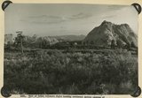
1879
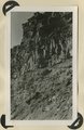
1880
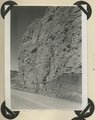
1881
1882
1883
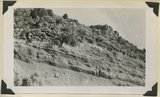
1884
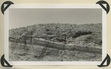
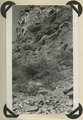
1885
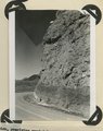
1886
1887
1888
1889
1890
1891
1892
1893
1894
1895
1896
1897
1898
1899
1900
1901
1902
1903
1904
1905
1906
1907
1908
1909
1910
1911
1912
1913
1914
1915
1916
1917
1918
1919
1920
1921
1922
1923
1924
1925
1926
1927
1928
1929
1930
1931
1932
1933
1934
1935
1936
1937
1938
1939
1940
1941
1942
1943
1944
1945
1946
1947
1948
1949
1950
1951
1952
1953
1954
1955
1956
1957
1958
1959
1960
1961
1962
1963
1964
1965
1966
1967
1968
1969
1970
1971
1972
1973
1974
1975
1976
1977
1978
1979
1980
1981
1982
1983
1984
1985
1986
1987
1988
1989
1990
1991
1992
1993
Type
Image
3,521
Format
image/jpeg
3,451
application/pdf
70
Collection Name
Herbert E. Gregory
3,521
Filters:
Collection Name:
"Herbert E. Gregory"
Collection:
"uum_map"
Setname:
!(ir* OR ehsl*)
126
-
150
of
3,521
<
1
2
3
4
5
6
7
8
9
10
>
Gallery view
Number of results to display per page
10
25
50
100
200
Sort by Relevance
Sort by Title A-Z
Sort by Title Z-A
Sort by Date Ascending
Sort by Date Descending
Sort by Last Modified Ascending
Sort by Last Modified Descending
Sort by Photo Number
Title
Collection Number And Name
Photo Number
126
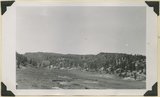
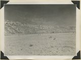
Lower Castle Creek Valley; broad floor of low gradient developed in Brian Head formation. Garfield County, UT, 1944
P0013 Herbert E. Gregory Photograph Collection
P0013n12_067_2927
127
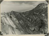
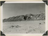
Moenkopi formation, Shnabkaib and upper red members. Chinle (upper right), knob of Shinarump offset by faulting (center skyline). Near mouth of Coal Canyon. Iron County, UT, 1942
P0013 Herbert E. Gregory Photograph Collection
P0013n12_001_2846
128
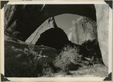
Natural bridge of Navajo sandstone. Span 85 feet, height to girder 76 feet. Willow Creek. Garfield County, UT, 1944
P0013 Herbert E. Gregory Photograph Collection
P0013n12_064_2922
129
Natural bridge of Navajo sandstone. Span 85 feet, height to girder 76 feet. Willow Creek. Garfield County, UT, 1944
P0013 Herbert E. Gregory Photograph Collection
P0013n12_064_2921
130
Panorama (a): Blue Springs meadows. A former valley leading to Mammoth Creek blocked by basalts from Miller Knoll (right skyline) became a lake that eventually cut an outlet northward through the Brian Head formation (upper left). Garfield County, UT, 1944
P0013 Herbert E. Gregory Photograph Collection
P0013n12_068_2929A
131
Panorama (b): Blue Springs meadows. A former valley leading to Mammoth Creek blocked by basalts from Miller Knoll (right skyline) became a lake that eventually cut an outlet northward through the Brian Head formation (upper left). Garfield County, UT, 1944
P0013 Herbert E. Gregory Photograph Collection
P0013n12_069_2929B
132
Panorama (c): Blue Springs meadows. A former valley leading to Mammoth Creek blocked by basalts from Miller Knoll (right skyline) became a lake that eventually cut an outlet northward through the Brian Head formation (upper left). Garfield County, UT, 1944
P0013 Herbert E. Gregory Photograph Collection
P0013n12_069_2929C
133
Panorama (d): Blue Springs meadows. A former valley leading to Mammoth Creek blocked by basalts from Miller Knoll (right skyline) became a lake that eventually cut an outlet northward through the Brian Head formation (upper left). Garfield County, UT, 1944
P0013 Herbert E. Gregory Photograph Collection
P0013n12_069_2929D
134
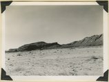
Panorama {a}. Flank of East Kaibab monocline, bordering alluvial floor of Paria Valley. Navajo sandstone (middle sky line), Upper Jurassic strata, and basal Cretaceous (left). Dips of 40 degrees decrease to 3 degrees within 1,000 feet. Kane County, UT, 1944
P0013 Herbert E. Gregory Photograph Collection
P0013n12_042_2889
135
Panorama {b}. Flank of East Kaibab monocline, bordering alluvial floor of Paria Valley. Navajo sandstone (middle sky line), Upper Jurassic strata, and basal Cretaceous (left). Dips of 40 degrees decrease to 3 degrees within 1,000 feet. Kane County, UT, 1944
P0013 Herbert E. Gregory Photograph Collection
P0013n12_042_2890
136
Panorama {c}. Flank of East Kaibab monocline, bordering alluvial floor of Paria Valley. Navajo sandstone (middle sky line), Upper Jurassic strata, and basal Cretaceous (left). Dips of 40 degrees decrease to 3 degrees within 1,000 feet. Kane County, UT, 1944
P0013 Herbert E. Gregory Photograph Collection
P0013n12_042_2891
137
Panorama {d}. Flank of East Kaibab monocline, bordering alluvial floor of Paria Valley. Navajo sandstone (middle sky line), Upper Jurassic strata, and basal Cretaceous (left). Dips of 40 degrees decrease to 3 degrees within 1,000 feet. Kane County, UT, 1944
P0013 Herbert E. Gregory Photograph Collection
P0013n12_043_2892
138
Panorama {e}. Flank of East Kaibab monocline, bordering alluvial floor of Paria Valley. Navajo sandstone (middle sky line), Upper Jurassic strata, and basal Cretaceous (left). Dips of 40 degrees decrease to 3 degrees within 1,000 feet. Kane County, UT, 1944
P0013 Herbert E. Gregory Photograph Collection
P0013n12_043_2893
139
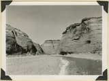
Paria River below White Rock Spring. Wall of Navajo sandstone capped by Carmel formation. Kane County, UT, 1944
P0013 Herbert E. Gregory Photograph Collection
P0013n12_046_2897
140
Paria river below White Rock Spring. Wall of Navajo sandstone capped by Carmel formation. Upper Jurassic rocks on right sky line. Kane County, UT, 1944
P0013 Herbert E. Gregory Photograph Collection
P0013n12_046_2898
141
Part of Kolob volcanic field looking southeast across canyons of Virgin River to Moccasin Terrace (skyline). Lava (foreground) has buried rough topography developed on Chinle and Navajo. Above it rises island like Pine Valley Peak of Navajo sandstone (upper right). Towers of Zion (upper left). Washington County, UT, 1942
P0013 Herbert E. Gregory Photograph Collection
P0013n12_006_2853
142
Parunuweap formation overlying Moenkopi; on divide between two tributaries to Virgin River near Grafton. Washington County, UT, 1942
P0013 Herbert E. Gregory Photograph Collection
P0013n12_005_2852
143
Parunuweap formation, covered by basalt flow. La Verkin Canyon, Washington County, UT, 1942
P0013 Herbert E. Gregory Photograph Collection
P0013n12_002_2848
144
Parunuweap formation, covered by basalt flow. La Verkin Canyon, Washington County, UT, 1942
P0013 Herbert E. Gregory Photograph Collection
P0013n12_003_2849
145
Parunuweap formation, overlying eroded Moenkopi strata. Federal highway 15, Virgin River Valley, near Grafton. Washington County, UT, 1942
P0013 Herbert E. Gregory Photograph Collection
P0013n12_003_2850
146
Parunuweap formation, Pliocene?, overlying Moenkopi beds (concealed by talus) and capped by basalt. Lower La Verkin Canyon, Washington County, UT, 1943
P0013 Herbert E. Gregory Photograph Collection
P0013n12_007_2854
147
Parunuweap formation, thin bedded phase; overlies upturned Moenkopi, Lawrence Canyon, Iron County, UT, 1942. View near mouth of Lawrence Canyon.
P0013 Herbert E. Gregory Photograph Collection
P0013n12_002_2847
148
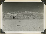
Permian limestones (Kaibab) overlain by the Triassic Moenkopi. Head of Kaibab Gulch, along Kanab-Paria road. Kane County, UT, 1944
P0013 Herbert E. Gregory Photograph Collection
P0013n12_049_2900
149
Pinnacles of Navajo sandstone in House Rock Valley along the course of Kaibab Creek. Eroded part of East Kaibab monocline. Kane County, UT, 1944
P0013 Herbert E. Gregory Photograph Collection
P0013n12_044_2894
150
Sevier River formation overlaid by basalt near mouth of Corral Creek on highway 89. Garfield County, Utah, 1944
P0013 Herbert E. Gregory Photograph Collection
P0013n12_075_2940
126
-
150
of
3,521
<
1
2
3
4
5
6
7
8
9
10
>