Home
Browse
Ask Us
Chat
Harmful Language Statement
Log in
Theses & Dissertations
Advanced Search
Year
1953
1954
1955
1956
1957
1958
1959
1960
1961
1962
1963
1964
1965
1966
1967
1968
1969
1970
1971
1972
1973
1974
1975
1976
1977
1978
1979
1980
1981
1982
1983
1984
1985
1986
1987
1988
1989
1990
1991
1992
1993
1994
1995
1996
1997
1998
1999
2000
2001
2002
2003
2004
2005
2006
2007
2008
2009
2010
2011
2012
2013
2014
2015
2016
2017
2018
2019
2020
TO
1953
1954
1955
1956
1957
1958
1959
1960
1961
1962
1963
1964
1965
1966
1967
1968
1969
1970
1971
1972
1973
1974
1975
1976
1977
1978
1979
1980
1981
1982
1983
1984
1985
1986
1987
1988
1989
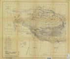
1990
1991
1992
1993
1994
1995
1996
1997
1998
1999
2000
2001
2002
2003
2004
2005
2006
2007
2008
2009
2010
2011
2012
2013
2014
2015
2016
2017
2018
2019
2020
School Or College
College of Social & Behavioral Science
131
Department
Geography
131
Publication Type
thesis
88
dissertation
33
online portfolio
8
map
2
Subject
GIS
12
Geography
12
Remote sensing
11
Fire
6
Paleoecology
6
Geography--Research--United States
5
Climate
4
Pollen
4
Utah
4
China
3
Climate change
3
Glaciology
3
Holocene
3
Physical geography
3
Vegetation
3
Agent-based model
2
Alaska
2
Charcoal
2
Climate Change
2
Evacuation
2
Glaciers
2
Great Salt Lake
2
Greenland ice sheet
2
Hyperspectral
2
Lake Bonneville
2
Natural gas
2
Palynology
2
Snow
2
Stratigraphic geology
2
Wildfire
2
climate change
2
fire spread modeling
2
geography
2
reverse geocoding
2
traffic simulation
2
triggers
2
wildfire evacuation
2
Snowmelt
1
Thesis and dissertation georeferencing project
1
2SFCA
1
Abrupt climate change events
1
Abu sayyaf group
1
Accessibility
1
Aerial photography
1
Agriculture
1
Amazon
1
Antarctica
1
Aquifer
1
Artificial Neural Networks
1
Atlas
1
Atmospheric sciences
1
Avalanche forecasting
1
Avalanche models
1
Baja California
1
Bicycle
1
Biogeochemistry
1
Bolivia
1
Bonneville Basin
1
Breast cancer
1
Bromus tectorum
1
Burkina Faso
1
Cactaceae
1
Cartography--United States
1
Caryophyllales
1
Cedar rapids
1
Change detection
1
Cheatgrass
1
Childhood Malnutrition
1
China economic development
1
China regional development
1
China socioeconomic
1
Cienega
1
City planning -- Utah -- Salt Lake City Land use -- Utah -- Salt Lake City
1
Ciénega
1
Clustering
1
Coal trade, Utah
1
Colorado River Basin
1
Computer simulation
1
Conservation
1
Crime
1
Cryosphere
1
Decision support system
1
Deer mouse
1
Dendroctonus
1
Desert wetland
1
Desiccation
1
Diatoms
1
Diploid
1
Disaster management
1
Distribution
1
Disturbance ecology
1
Diversity
1
Drought
1
Dust
1
ENSO
1
Earth sciences
1
East Canyon Reservoir
1
Echinocereus
1
Ecology
1
Economic Transition
1
El Nino Southern Oscillation
1
Emergency
1
Endmember selection
1
Energy balance
1
Engelmann spruce
1
Environmental Hazards
1
Environmental science
1
Exploratory data analysis
1
Family gathering
1
Fire History
1
Fire, Fremont
1
Firn
1
Flash flood
1
Flood
1
Food Security
1
Foreign direct investment
1
Forest disturbance
1
Forest ecology
1
Forestry
1
Geocomputation
1
Geographic information science
1
Geographic information systems
1
Geography - Research - Information services
1
Geography - Research - information services
1
Geography - information services
1
Geospatial
1
Glacier hydrology
1
Glacier meltwater
1
Glaciers--Alaska
1
Greenland
1
Habitat model
1
Hantavirus
1
Hazards
1
Headwaters
1
Health and environmental sciences
1
Heinrich Events
1
Hydroclimate
1
Hyperspectral time series
1
HyspIRI
1
Ice dynamics
1
Ice sheets--Greenland
1
Idaho
1
Incidence
1
Index
1
Institutions
1
Interannual variability
1
Intermountain West
1
Joint accessibility
1
Lake sediments
1
Lake surface area
1
Land Surface Temperature
1
Landsat
1
Landscape ecology
1
Late-glacial
1
Leucosticte
1
LiDAR system
1
Lidar
1
Life course
1
MESMA
1
MODIS
1
Maxent
1
Medieval climate anomaly
1
Melt-freeze
1
Methane, Environmental aspects, Uganda
1
Methane,Environmental aspects, Uganda;Remote sensing,Uganda
1
Microbial bioherm
1
Microbialite
1
Minnesota
1
Mobile object
1
Modeling
1
Monsoon
1
Monsoons
1
Morphomertics
1
Mountain terrain
1
Mulitmodal
1
Multivariate adaptive regression splines
1
NDVI time-series
1
Native American
1
NetLogo
1
Niche model
1
Nutrition
1
Oak savanna
1
Offset tracking
1
Orthoimagery
1
Pahoehoe flow
1
Paleo Indians
1
Paleo fire record
1
Paleoclimate
1
Paleoclimatology
1
Paleofire
1
Paleolimnology
1
Patterns and determinants
1
Peromyscus maniculatus
1
Phenological modeling
1
Phenology
1
Philippines
1
Phytoliths
1
Picea
1
Plant functional type
1
Population
1
Preparedness
1
Public transportation
1
Pure sciences
1
Quantile Regression
1
Radar
1
Random Forest
1
Range Creek Canyon
1
Recreation
1
Remote Sensing
1
Remote sensing classification
1
Reservoir
1
Resilience
1
Return-entry
1
Rocky Mountains
1
SDI
1
Sage-grouse
1
Sagebrush
1
Salt Lake
1
Salt Lake City, Utah
1
Scatterometry
1
Sediments
1
Segregation in Utah
1
Sensitivity analysis
1
Sherburne
1
Shoreline records
1
Snow accumulation
1
Social Vulnerability
1
Social Vulnerability Index
1
Social interaction potential metric
1
Social sciences
1
Socioeconomic
1
Soils
1
Southeast Asian studies
1
Southwest north america
1
Spaital analysis
1
Spatial
1
Spatial data infrastructure
1
Spatial resolution
1
Spatial-temporal evolution
1
Spatial-temporal modeling
1
Species classification
1
Species-Specific
1
Spectral Mixture Analysis
1
Spectral mixture analysis
1
Speleothem
1
Spruce beetle
1
Stable isotopes
1
Statistical modeling
1
Statistics
1
Storm runoff
1
Stromatolite
1
Suzhou
1
Synoptic Climatology
1
TDR
1
Teleconnections
1
Terrorism
1
Thrombolite
1
Time geography
1
Tooele Valley, Utah
1
Traffic flow
1
Transformatio
1
Transition Towns
1
Transportation
1
Twitter
1
Uganda
1
Upper Colorado River Basin
1
Urban Expansion
1
Urban Forest
1
Urban planning
1
VGI
1
Vegetation classification
1
Vegetation mapping
1
Vegetation mapping, Uganda;Wetland ecology, Uganda
1
Vegetation mapping,Uganda;Wetland ecology, Uganda
1
Vegetation phenology
1
Vegetation recovery
1
Viewshed
1
Visualization
1
Volcanic hazard mitigation
1
Volunteer geographic information
1
Water resources
1
Western North America
1
Western U.S.
1
Wetlands
1
Wildfire entrapment
1
Woody cover
1
Wuhan
1
Wyoming
1
accessibility
1
ambulance
1
attitude
1
backup coverage
1
bicycling frequency
1
boosted regression trees
1
calibrated AUC
1
carbon footprint
1
climate change impacts
1
climate change mitigation
1
crevasses
1
disturbance
1
emergency medical service
1
evacuation trigger points
1
firefighter entrapment
1
flamMap
1
floating catchment area
1
flow reversals
1
fluid dynamics
1
generalized additive model
1
geographic information systems
1
groundwater flow
1
hydrodynamics
1
hydrofracture
1
hypermarket
1
land use
1
live fuel moisture content
1
location modeling
1
medical drone
1
niche modeling
1
out-of-hospital cardiac arrest
1
preferences
1
public lands
1
random forest regression trees
1
remote sensing
1
retail internationalization
1
route choice
1
social movements
1
spatial access
1
spatial optimization
1
statistical modeling
1
urban growth
1
values
1
vegetation change
1
wilderness
1
wildfire spread modeling
1
wildland fire
1
wildland urban interface evacuation
1
More
Filters:
Department:
"Geography"
Collection:
"ir_etd"
101
-
125
of
131
<
1
2
3
4
5
6
>
Gallery view
Number of results to display per page
10
25
50
100
200
Sort by Relevance
Sort by Title A-Z
Sort by Title Z-A
Sort by Date Ascending
Sort by Date Descending
Sort by Last Modified Ascending
Sort by Last Modified Descending
Title
Setname
Type
101
The role of early life socioeconomic status in female breast cancer incidence
ir_etd
Text
102
Seasonal and spatial distribution of wet snow on three volcanoes in Western Washington mapped with synthetic aperture radar
ir_etd
Text
103
Seasonal moisture and fire variability in the Northern Colorado Plateau: a case study in Rage Creek Canyon, UT
ir_etd
Text
104
Sedimentological evidence of late holocene disturbance on the Wasatch Plateau, Utah, USA
ir_etd
Text
105
Seismic risk perception and household adjustment in Salt Lake City, Utah
ir_etd
Text
106
Snow cover trends over high Mountain asia from modis snow cover and grain size
ir_etd
Text
107
South American Immigration to Utah
ir_etd
Text
108
Spatial access and local demand for emergency medical services in utah
ir_etd
Text
109
Spatial and aspatial residential segregation measures: Salt Lake County 1999 to 2007
ir_etd
Text
110
Spatial correlation analysis of niÑo3.4 sea surface temperatures with western north america hydroclimate
ir_etd
Text
111
Spatial modeling of wildland fire ignition potential in Utah
ir_etd
Text
112
Spatial representation in the social interaction potential metric: an analysis of scale and parameter sensitivity
ir_etd
Text
113
Spatially calibrated model of annual accumulation rate on the Greenland ice sheet (1958-2007)
ir_etd
Text
114
Study of two vegetation-related disturbances (beetle herbivory and wildfire) in the western united states using optical remote sensing
ir_etd
Text
115
Subsurface stratigraphy of the Wasatch Formation of the Uinta Basin, Utah (Google Earth map overlay KMZ file)
ir_etd
Image
116
Subsurface stratigraphy of the Wasatch Formation of the Uinta Basin, Utah (Maps)
ir_etd
Image
117
Synthetic aperture radar snow conditions: seasonal and diurnal signals in the upper Indus Basin
ir_etd
Text
118
Thinking inside the black box: enhancing the social vulnerability index with an artificial neural network
ir_etd
Text
119
Tooele Valley, Utah: A regional interpretation of the changing economies
ir_etd
Text
120
Tracking a wildfire in areas of high relief using volunteered geographic information: a viewshed application
ir_etd
Text
121
Tropical forcing of West Antarctic ice Sheet surface mass balance variability
ir_etd
Text
122
Understanding the relationship between fire, climate, and population in Central Uganda from 1990-2010
ir_etd
Text
123
Using hyperspectral data to classify vegetation at the plant functional type-level in mountain terrain at three spatial resolutions
ir_etd
Text
124
Using species distribution models to quantify climate change impacts on the rosy-finch superspecies: an alpine obligate
ir_etd
Text
125
Utah coal industry: a study in economic geography
ir_etd
Text
101
-
125
of
131
<
1
2
3
4
5
6
>