Home
Browse
Ask Us
Chat
Harmful Language Statement
Log in
Photo Archives
Advanced Search
About
Over 70,000 photos covering a variety of topics from Marriott Library Special Collections
Year
1872
1873
1874
1875
1876
1877
1878
1879
1880
1881
1882
1883
1884
1885
1886
1887
1888
1889
1890
1891
1892
1893
1894
1895
1896
1897
1898
1899
1900
1901
1902
1903
1904
1905
1906
1907
1908
1909
1910
1911
1912
1913
1914
1915
1916
1917
1918
1919
1920
1921
1922
1923
1924
1925
1926
1927
1928
1929
1930
1931
1932
1933
1934
1935
1936
1937
1938
1939
1940
1941
1942
1943
1944
1945
1946
1947
1948
1949
1950
1951
1952
1953
1954
1955
1956
1957
1958
1959
1960
1961
1962
1963
1964
1965
1966
1967
1968
1969
1970
1971
1972
1973
1974
1975
1976
1977
1978
1979
1980
1981
1982
1983
1984
1985
1986
1987
1988
1989
1990
1991
1992
1993
TO
1872
1873
1874
1875
1876
1877
1878
1879
1880
1881
1882
1883
1884
1885
1886
1887
1888
1889
1890
1891
1892
1893
1894
1895
1896
1897
1898
1899
1900
1901
1902
1903
1904
1905
1906
1907
1908
1909
1910
1911
1912
1913
1914
1915
1916
1917
1918
1919
1920
1921
1922
1923
1924
1925
1926
1927
1928
1929
1930
1931
1932
1933
1934
1935
1936
1937
1938
1939
1940
1941
1942
1943
1944
1945
1946
1947
1948
1949
1950
1951
1952
1953
1954
1955
1956
1957
1958
1959
1960
1961
1962
1963
1964
1965
1966
1967
1968
1969
1970
1971
1972
1973
1974
1975
1976
1977
1978
1979
1980
1981
1982
1983
1984
1985
1986
1987
1988
1989
1990
1991
1992
1993
Type
Image
3,521
Format
image/jpeg
3,451
application/pdf
70
Collection Name
Herbert E. Gregory
3,521
Filters:
Collection Name:
"Herbert E. Gregory"
Collection:
"uum_map"
101
-
125
of
3,521
<
1
2
3
4
5
6
7
8
9
10
>
Gallery view
Number of results to display per page
10
25
50
100
200
Sort by Relevance
Sort by Title A-Z
Sort by Title Z-A
Sort by Date Ascending
Sort by Date Descending
Sort by Last Modified Ascending
Sort by Last Modified Descending
Sort by Photo Number
Title
Collection Number And Name
Photo Number
101
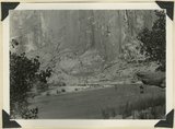
Escalante Canyon down stream from Big Bend. Garfield County, UT, 1944
P0013 Herbert E. Gregory Photograph Collection
P0013n12_056_2909
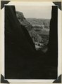
102
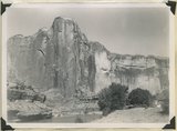
Escalante Canyon walls of Navajo sandstone at Big Bend camp. Moonlight view. Garfield County, UT, 1944
P0013 Herbert E. Gregory Photograph Collection
P0013n12_059_2915
103
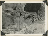
Escalante Canyon, cliff cave 3 miles above Cave Camp. Garfield County, UT, 1944
P0013 Herbert E. Gregory Photograph Collection
P0013n12_057_2910
104
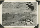
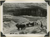
Escalante Canyon. Pueblo ruins in cliff cave. Navajo sandstone. Scale shown by horse. Garfield County, UT, 1944
P0013 Herbert E. Gregory Photograph Collection
P0013n12_057_2911
105
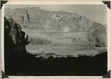
Escalante Canyon. Sheer wall of Navajo sandstone 840 feet high. Garfield County, UT, 1944
P0013 Herbert E. Gregory Photograph Collection
P0013n12_059_2914
106
Escalante River at Big Bend, flowing east. At times of high water the stream flows across Kayenta formation at the meander neck (lower right). Garfield County, UT, 1944
P0013 Herbert E. Gregory Photograph Collection
P0013n12_061_2917
107
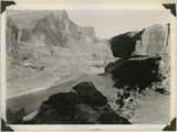
Escalante River at Big Bend, flowing west. After surrounding the tower of Navajo sandstone (center), the river comes within 300 feet of its east flowing section at the base of the wall (upper left). Garfield County, UT, 1944
P0013 Herbert E. Gregory Photograph Collection
P0013n12_060_2916
108
Flat lying Upper Jurassic (foreground) and Cretaceous strata bed abruptly upward against the Navajo on the flank of the East Kaibab monocline (left sky line). Table Cliffs (right sky line) is about 50 miles north. Paria Valley near Adairville. Kane County, UT. 1944
P0013 Herbert E. Gregory Photograph Collection
P0013n12_039_2886
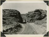
109
Gap cut in Navajo sandstone by Kaibab Creek where it leaves its structural valley to cross East Kaibab monocline. Northward through the gap House Rock Valley and Kaibab Plateau are visible. Kane County, UT. 1944
P0013 Herbert E. Gregory Photograph Collection
P0013n12_044_2895
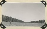
110
Glaciated surface showing (roche mountain): glade in spruce forest at top of Aquarius Plateau at altitude of 10,800 feet. Near the head of Antimony Creek, Garfield County, UT, 1943
P0013 Herbert E. Gregory Photograph Collection
P0013n12_014_2861_1
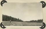
111
Glaciated surface showing (roche mountain): glade in spruce forest at top of Aquarius Plateau at altitude of 10,800 feet. Near the head of Antimony Creek, Garfield County, UT, 1943
P0013 Herbert E. Gregory Photograph Collection
P0013n12_014_2861_2
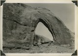
112
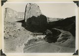
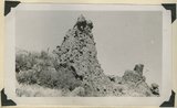
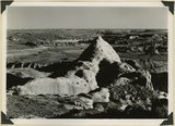
Gothic Arch. Width 174 feet, estimated height 190 feet. End of a buttress of Navajo sandstone resting on Kayenta. Soda Creek branch of Escalante River. Garfield County, UT, 1944
P0013 Herbert E. Gregory Photograph Collection
P0013n12_063_2920
113
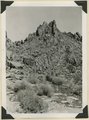
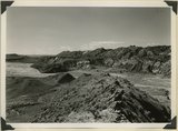
Head of Break Neck Trail down the south wall of Escalante Canyon (middle distance). Navajo sandstone. Garfield County, UT, 1944
P0013 Herbert E. Gregory Photograph Collection
P0013n12_055_2907
114
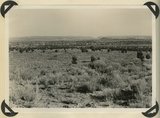
Igneous breccia in Brian Head formation(?), upper Panguitch Creek. Garfield County, UT, 1944
P0013 Herbert E. Gregory Photograph Collection
P0013n12_074_2939
115
Joints and small faults in Navajo sandstone along the crest (Coxcomb) of East Kaibab monocline. Kane County, UT, 1944
P0013 Herbert E. Gregory Photograph Collection
P0013n12_045_2896
116
Kaibab limestone (lower wall,left, breccia (marks unconformable contact), and basal Moenkopi limestone and shales. Mouth of Kaibab Gulch. Kane County, UT, 1944
P0013 Herbert E. Gregory Photograph Collection
P0013n12_047_2899
117
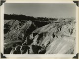
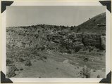
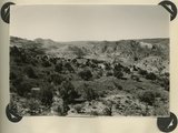
Little valleys near head of Pole Creek. Lower Brian Head formation capped by decomposed igneous conglomerate. Garfield County, UT. 1943
P0013 Herbert E. Gregory Photograph Collection
P0013n12_019_2867
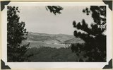
118
Looking east across Glen Canyon from east entrance to Hole-in-the-Rock. Navajo sandstone (foreground and skyline), below it Kayenta and Wingate. Garfield County, UT, 1944
P0013 Herbert E. Gregory Photograph Collection
P0013n12_055_2906
119
Looking east across Paria River Canyon where it separates West and East Clark Benches. Upper Jurassic (foreground) and Navajo (background) dip northeast. Navajo Mountain and Kaiparowits Plateau are on opposite sides of Glen Canyon. Kane County, UT. 1944
P0013 Herbert E. Gregory Photograph Collection
P0013n12_037_2884
120
Looking northwest across Horse Lake Valley. Basalt (foreground), Pyroclastics (background). Garfield County, UT, 1944
P0013 Herbert E. Gregory Photograph Collection
P0013n12_066_2924
121
Looking south (up dip) down the Paria River, which has widened its floor and dissected its borders in Upper Jurassic rocks (foreground) and cut a deep narrow canyon in the Navajo sandstone (background). Site of the abandoned Adairville. Kane County UT, 1944
P0013 Herbert E. Gregory Photograph Collection
P0013n12_038_2885
122
Looking south along Paria River from the mouth of Shurtz Gorge. Navajo sandstone in East Kaibab monocline is overlaid with decreasing dips by Upper Jurassic (banked against the Navajo), Dakota, and Tropic (foreground and left sky line). Erosion surface (middle distance) bevels upturned rocks. Kane County, UT, 1944
P0013 Herbert E. Gregory Photograph Collection
P0013n12_041_2888
123
Looking south, up dip, across West Clark Bench, Upper Jurassic and Dakota (butte), to the Paria Terrace, Navajo sandstone. Paria River, which passes through 'The Gap' is joined by Kaibab Creek. Kane County, UT. 1944
P0013 Herbert E. Gregory Photograph Collection
P0013n12_036_2883
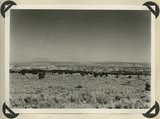
124
Looking southward across House Rock Valley from West Clark Bench. West dipping Navajo sandstone trenched by Kaibab Creek (middle distance) is a part of the East Kaibab monocline; east dipping limestones (skyline) are the cap rocks of the Kaibab upwarp. Kane County, UT, 1944
P0013 Herbert E. Gregory Photograph Collection
P0013n12_035_2882
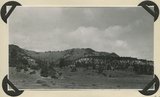
125
Looking west across Panguitch. Sevier River formation (foreground), alluvium (middle distance), basalt (left center), and pyroclastic slopes leading to Little Creek Peak (background), on the east wall of Bear Valley. Garfield County, UT, 1944
P0013 Herbert E. Gregory Photograph Collection
P0013n12_065_2923
101
-
125
of
3,521
<
1
2
3
4
5
6
7
8
9
10
>