Home
Browse
Ask Us
Chat
Harmful Language Statement
Log in
Advanced Search
Year
1850
1851
1852
1853
1854
1855
1856
1857
1858
1859
1860
1861
1862
1863
1864
1865
1866
1867
1868
1869
1870
1871
1872
1873
1874
1875
1876
1877
1878
1879
1880
1881
1882
1883
1884
1885
1886
1887
1888
1889
1890
1891
1892
1893
1894
1895
1896
1897
1898
1899
1900
1901
1902
1903
1904
1905
1906
1907
1908
1909
1910
1911
1912
1913
1914
1915
1916
1917
1918
1919
1920
1921
1922
1923
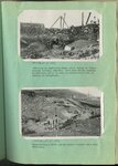
1924
1925
1926
1927
1928
1929
1930
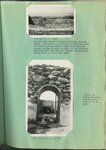
1931
1932
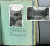
1933
1934
1935
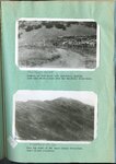
1936
1937
1938
1939
1940
1941
1942
1943
1944
1945
1946
1947
1948
1949
1950
1951
1952
1953
1954
1955
1956
1957
1958
1959
1960
1961
1962
1963
1964
1965
1966
1967
1968
1969
1970
1971
1972
1973
1974
1975
1976
1977
1978
1979
1980
1981
1982
1983
1984
1985
1986
1987
1988
1989
1990
1991
1992
1993
1994
1995
1996
1997
1998
1999
2000
TO
1850
1851
1852
1853
1854
1855
1856
1857
1858
1859
1860
1861
1862
1863
1864
1865
1866
1867
1868
1869
1870
1871
1872
1873
1874
1875
1876
1877
1878
1879
1880
1881
1882
1883
1884
1885
1886
1887
1888
1889
1890
1891
1892
1893
1894
1895
1896
1897
1898
1899
1900
1901
1902
1903
1904
1905
1906
1907
1908
1909
1910
1911
1912
1913
1914
1915
1916
1917
1918
1919
1920
1921
1922
1923
1924
1925
1926
1927
1928
1929
1930
1931
1932
1933
1934
1935
1936
1937
1938
1939
1940
1941
1942
1943
1944
1945
1946
1947
1948
1949
1950
1951
1952
1953
1954
1955
1956
1957
1958
1959
1960
1961
1962
1963
1964
1965
1966
1967
1968
1969
1970
1971
1972
1973
1974
1975
1976
1977
1978
1979
1980
1981
1982
1983
1984
1985
1986
1987
1988
1989
1990
1991
1992
1993
1994
1995
1996
1997
1998
1999
2000
Type
Image/StillImage
18,820
Format
image/jpeg
18,820
Collection
C. R. Savage Company Portrait Collection
13,380
Classified Photographs
380
College of Law Publications
6
George M. Ottinger Photograph Collection
2,181
John Peter Simonson Photograph Collec...
29
Maps
4
Photo Archives
1,957
Ray King Collection
10
Regional History Center
256
Rural Utah Curated Collection
23
Shipler Collection Negative Preservat...
181
Taylor A. Woolley Papers
1
Thorne Photographs
379
UAIDA Main Collection
27
Utah River Running Photo Archives
6
More
Filters:
Type:
"Image/StillImage"
Date:
"1923"
Format:
image
Setname:
!(ir* OR ehsl*)
76
-
100
of
18,820
<
1
2
3
4
5
6
7
8
9
10
>
Gallery view
Number of results to display per page
10
25
50
100
200
Sort by Relevance
Sort by Title A-Z
Sort by Title Z-A
Sort by Date Ascending
Sort by Date Descending
Sort by Last Modified Ascending
Sort by Last Modified Descending
Title
Date
Type
Setname
76
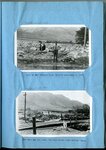
Flooding in Willard, Utah : looking down Main Street, Willard, from the north end of the town, August 18, 1923 [and] Barn containing livestock, automobile trucks and 75 tons of hay, carried 1/4 mile and deposited on Main Street
1923
Image/StillImage
uum_map
77
Flooding in Willard, Utah : site of the Willard flood barrier, Septembre 3, 1923 [and] same May 10, 1924, two days after construction began.
1923; 1924
Image/StillImage
uum_map
78
Flooding in Willard, Utah : scenes along Main Street, Willard, following the flood of August 13, 1923
1923
Image/StillImage
uum_map
79
Ford Creek floods : Result of and flow from torrential flood, Ford Creek, August 13, 1923 [and] The disaster of 1923 repeated on Ford Creek in a series of three floods in 1930
1923; 1930
Image/StillImage
uum_map
80
Parowan City flood barrier : Sand and gravel were a serious menace to Parowan City and to the irrigation system before the barrier was built in 1925 [and] Gravel deposited above the Parowan flood barrier supplies the building needs of the community
1923; 1924; 1925
Image/StillImage
uum_map
81
Salt Creek flooding : Lower barrier on Salt Creek above Nephi at the beginning of the third season of operation [and] Salt Creek out of bounds at Plaster Mill above Nephi, on the evening of Aug. 13, 1923
1923; 1932
Image/StillImage
uum_map
82
Spillway on Payson Creek : Constructing the main barrier and spillway in Pigeon Creek, rocks dragged into place by teams are grouted with concrete to hold them in position [and] A secondary spillway on Payson Creek made of timber
1923; 1924; 1925; 1926; 1927; 1928; 1929; 1930; 1931; 1932; 1933
Image/StillImage
uum_map
83
Manti barrier at the close of the high water season [and] Manti barrier spillway in operation
1923; 1924; 1925; 1926; 1927; 1928; 1929; 1930; 1931; 1932; 1933
Image/StillImage
uum_map
84
Kessler Canyon barrier spillway : looking up stream from Garfield smelter at series of control structures in Kessler Canyon [and] Looking down stream across site of main barrier spillway, Kessler Canyon, during construction
1923; 1924; 1925; 1926; 1927; 1928; 1929; 1930; 1931; 1932; 1933
Image/StillImage
uum_map
85
Kessler Canyon barrier spillway : Lifting boulders out of the ground for use in building main spillway, Kessler Canyon [and] Boulders being placed by heavy derrick, in foundation of main spillway, Kessler Canyon
1923; 1924; 1925; 1926; 1927; 1928; 1929; 1930; 1931; 1932; 1933
Image/StillImage
uum_map
86
Kessler Canyon barrier spillway looking downstream toward Garfield smelter [and] The same after a forrential flood which reached a depth of 7 feet over the 70 foot crest
1923; 1924; 1925; 1926; 1927; 1928; 1929; 1930; 1931; 1932; 1933
Image/StillImage
uum_map
87
Kessler Canyon barrier spillway : building an equalizing check above intake to tunnel through Garfield Smelter [and] Constructing a check dam in Kessler Canyon below main structure
1923; 1924; 1925; 1926; 1927; 1928; 1929; 1930; 1931; 1932; 1933
Image/StillImage
uum_map
88
Kessler Canyon barrier spillway : looking down stream from main spillway, Kessler Canyon [and] Detail of rubble-concrete construction
1923; 1924; 1925; 1926; 1927; 1928; 1929; 1930; 1931; 1932; 1933
Image/StillImage
uum_map
89
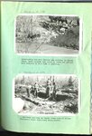
Erosion on Santa Clara Creek is a problem of great concern to the farmers of St. George and Santa Clara
1923; 1924; 1925; 1926; 1927; 1928; 1929; 1930; 1931; 1932; 1933
Image/StillImage
uum_map
90
Erosion on Santa Clara Creek : an attempt at control on Santa Clara Creek
1923; 1924; 1925; 1926; 1927; 1928; 1929; 1930; 1931; 1932; 1933
Image/StillImage
uum_map
91
Chalk Creek before control, looking up stream during period of highwater in spring, when stream was carrying large quantities of gravel [and] Looking up stream across north end of Fillmore barrier, first season of operation
1923; 1924; 1925; 1926; 1927; 1928; 1929; 1930; 1931; 1932; 1933
Image/StillImage
uum_map
92
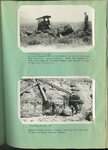
Kessler Canyon barrier spillway : Guniting a rubble-concrete wing wall, Kessler Canyon [and] Gasoline driven shovel building the flood barrier, Kessler Canyon
1923; 1924; 1925; 1926; 1927; 1928; 1929; 1930; 1931; 1932; 1933
Image/StillImage
uum_map
93
Kessler Canyon barrier spillway : spillway through man barrier, Kessler Canyon [and] The flood stream drops over a circular crest into a stilling pond
1923; 1924; 1925; 1926; 1927; 1928; 1929; 1930; 1931; 1932; 1933
Image/StillImage
uum_map
94
Erosion of foot hills near Bountiful, showing goat herd which grazes over the Bountiful water-shed [and] Near the crest of the Davis County water-shed where floods originate
1923; 1924; 1925; 1926; 1927; 1928; 1929; 1930; 1931; 1932; 1933
Image/StillImage
uum_map
95
Haights Creek Diversion dam in process of construction
1923; 1924; 1925; 1926; 1927; 1928; 1929; 1930; 1931; 1932; 1933
Image/StillImage
uum_map
96
Kessler Canyon main spillway structure
1923; 1924; 1925; 1926; 1927; 1928; 1929; 1930; 1931; 1932; 1933
Image/StillImage
uum_map
97
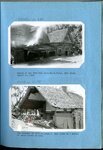
Butcher Shop, Mine Office and Wasatch Store, Sunnyside
1920; 1921; 1922; 1923; 1924; 1925; 1926; 1927; 1928; 1929; 1930; 1931; 1932; 1933; 1934; 1935; 1936; 1937; 1938; 1939; 1940
Image/StillImage
uum_map
98
Trip assembly yard Castle Gate Number 2 Mine at Willow Creek
1912; 1913; 1914; 1915; 1916; 1917; 1918; 1919; 1920; 1921; 1922; 1923; 1924; 1925; 1926; 1927; 1928; 1929; 1930; 1931; 1932; 1933; 1934; 1935; 1936; 1937; 1938; 1939; 1940; 1941; 1942; 1943; 1944; 1945; 1946; 1947; 1948; 1949; 1950
Image/StillImage
uum_map
99
Haulage Portal Castle Gate Number 2 Mine, Bridge over Willow Creek
1920; 1921; 1922; 1923; 1924; 1925; 1926; 1927; 1928; 1929; 1930
Image/StillImage
uum_map
100
Castle Gate Tipple and townsite
1920; 1921; 1922; 1923; 1924; 1925; 1926; 1927; 1928; 1929; 1930; 1931; 1932; 1933; 1934; 1935; 1936; 1937; 1938; 1939; 1940
Image/StillImage
uum_map
76
-
100
of
18,820
<
1
2
3
4
5
6
7
8
9
10
>