Home
Browse
Ask Us
Chat
Harmful Language Statement
Log in
Photo Archives
Advanced Search
About
Over 70,000 photos covering a variety of topics from Marriott Library Special Collections
Year
1845
1846
1847
1848
1849
1850
1851
1852
1853
1854
1855
1856
1857
1858
1859
1860
1861
1862
1863
1864
1865
1866
1867
1868
1869
1870
1871
1872
1873
1874
1875
1876
1877
1878
1879
1880
1881
1882
1883
1884
1885
1886
1887
1888
1889
1890
1891
1892
1893
1894
1895
1896
1897
1898
1899
1900
1901
1902
1903
1904
1905
1906
1907
1908
1909
1910
1911
1912
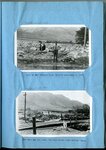
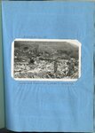
1913
1914
1915
1916
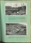
1917
1918
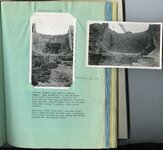
1919
1920
1921
1922
1923
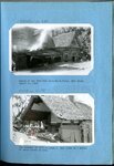
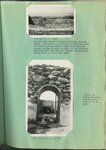
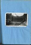
1924
1925
1926
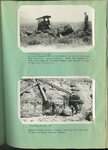
1927
1928
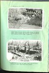
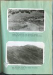
1929
1930
1931
1932
1933
1934
1935
1936
1937
1938
1939
1940
1941
1942
1943
1944
1945
1946
1947
1948
1949
1950
1951
1952
1953
1954
1955
1956
1957
1958
1959
1960
1961
1962
1963
1964
1965
1966
1967
1968
1969
1970
1971
1972
1973
1974
1975
1976
1977
1978
1979
1980
1981
1982
1983
1984
1985
1986
1987
1988
1989
1990
1991
1992
1993
1994
1995
1996
1997
1998
1999
2000
TO
1845
1846
1847
1848
1849
1850
1851
1852
1853
1854
1855
1856
1857
1858
1859
1860
1861
1862
1863
1864
1865
1866
1867
1868
1869
1870
1871
1872
1873
1874
1875
1876
1877
1878
1879
1880
1881
1882
1883
1884
1885
1886
1887
1888
1889
1890
1891
1892
1893
1894
1895
1896
1897
1898
1899
1900
1901
1902
1903
1904
1905
1906
1907
1908
1909
1910
1911
1912
1913
1914
1915
1916
1917
1918
1919
1920
1921
1922
1923
1924
1925
1926
1927
1928
1929
1930
1931
1932
1933
1934
1935
1936
1937
1938
1939
1940
1941
1942
1943
1944
1945
1946
1947
1948
1949
1950
1951
1952
1953
1954
1955
1956
1957
1958
1959
1960
1961
1962
1963
1964
1965
1966
1967
1968
1969
1970
1971
1972
1973
1974
1975
1976
1977
1978
1979
1980
1981
1982
1983
1984
1985
1986
1987
1988
1989
1990
1991
1992
1993
1994
1995
1996
1997
1998
1999
2000
Type
Image
2,263
Image/StillImage
1,958
Format
image/jpeg
5,605
Collection Name
Shipler Studio
732
Frederick J. Pack
577
Maud May Babcock
529
Wasatch Mountain Club
482
Ruth Harwood
277
Emigration Canyon History
273
The Institute of the American West photograph collection, 1886-1985
204
Newell Beeman
191
A. Selden Millward
186
Clifford Percy Evans
158
Alta Club
153
Charles Neal
142
Elmore LeRoy photograph collection
105
Albion W. and Agnes Sharp Caine
92
Carl Weeks Photograph Collection
89
George D. Pyper
88
Mining Photograph Collection
83
Greek Archives
80
Fort Douglas
58
Everett Ruess Family
56
Kennecott Copper Corporation
52
Edward P. Jennings
40
Sigmund and Emma Helwing
40
Japanese Church of Christ
36
Ianthus Leo Richards photograph collection, 1910-1930
35
Ivy Baker Priest
35
Helen Bowring Ure photograph collection
33
Francis Armstrong
30
Herbert E. Gregory
29
Charles Kelly
28
Utah's Silver Queen: Susanna Egera Bransford Emery Holmes Delitch Engalitcheff photograph collection
28
Topaz, Utah and Hispanics in Utah films, 1940-1990
27
Grand Canyon
25
Seamount Family
24
E. A. Taylor
23
Louis Marcus
23
Rocky Mountain Power Company
23
Croydon Utah/Devil's Slide Cement Plant
22
C. Lowell Lees
21
Utah Flood Survey
21
Brigham Henry Roberts photograph collection, 1851-1933
20
Utah Humanities Research Foundation
18
Waldo Wilcox
18
Clarence Stevenson
17
Fred Harvey
17
Jean C. Stockton
17
Henry Y. Kasai
16
J. Willard and Alice Sheets Marriott
15
Milford and Alda F. Gardner
12
Elsie Ross Whittaker
11
Hope A. Hilton
11
Italian
11
Olive Woolley Burt
9
Rosezella Dalton Hardy
9
George Snell
8
Lila Eccles Brimhall
8
Philo T. Farnsworth
8
Utah Railroads
8
Bingham Stage Lines
7
Jack Burton
7
Preston Nutter Corporation
7
John Hamilton Morgan
6
Joseph E. Johnson
6
Lowry Nelson
6
Orvil LaVell Sadler
6
Salt Lake City, Utah
6
Vyrie Gray
6
Portrait photograph collection
5
Southern Slavic
5
Alberta Henry
4
Charles H. Andrus photograph collection
4
History of Bingham Canyon
4
John A. Peperakis
4
John W. Summerhays
4
Philip T. Blair
4
Provo, Utah
4
Ray Yourdon
4
Rose Thomas Graham
4
Wanda Clayton Thomas
4
Western and Mormon stereograph collection
4
Alice Lovina Manning Photographs
3
Clarice Short photograph collection
3
David Oman McKay
3
Hiram B. Clawson
3
Jean Westwood
3
Kunio Yamada digital photograph collection
3
Lyman P. Hunter
3
Melba Goff Matthews
3
Ole Pettit
3
Omer Call Stewart photograph collection
3
Ralph Chamberlin
3
William Caine Patrick
3
Agnes Just Reid
2
Barbara J. Hamblin
2
Benjamin M. Roe
2
Blacks in Utah
2
Byron A. Hunter photograph collection
2
Clifford Evans
2
Daniel Hadlond Thomas
2
John Esplin
2
John Mills Whitaker
2
Lowell Lindsay Bennion
2
Mack Smith Kesler
2
Maurice Abravanel
2
Miles Pratt Romney
2
Panoramas
2
Salt Lake Chamber of Commerce photograph collection
2
Sunstone Foundation photograph collection
2
The Great Salt Lake
2
Wallace and Mary Doi
2
Yosaburo Takehara digital photograph collection
2
Angus Woodbury
1
Arch Leonard Madsen
1
Blanche Kendall McKey
1
Burton W. Musser photograph collection, 1900-1966
1
Colorado
1
Edith LeRoy Richardson
1
Edward Hunter Family
1
Esther Landa photograph collection
1
Garfield, Utah
1
George A. Smith
1
Geraldine Palmer Jones
1
Helper, Utah
1
Ivor Sharp
1
Japanese American Citizens League Japanese in Utah Exhibit
1
Joyce Messersmith
1
LDS Church History
1
LeRoy Robertson photograph collection, 1945-1960
1
Leo Leonard
1
Marriner S. Eccles
1
Noel R. Barton
1
Price, Utah photograph collection
1
Rudger Clawson photograph collection, circa 1900
1
Simon Bamberger
1
Sumi Niiya Takemoto
1
U of U Presidents
1
Vernal, Utah
1
Wallace Stegner
1
William P. Nisbet photograph collection
1
More
Filters:
Collection:
"uum_map"
Format:
"image/jpeg"
Date:
"1923"
Format:
image
Setname:
!(ir* OR ehsl*)
76
-
100
of
5,605
<
1
2
3
4
5
6
7
8
9
10
>
Gallery view
Number of results to display per page
10
25
50
100
200
Sort by Relevance
Sort by Title A-Z
Sort by Title Z-A
Sort by Date Ascending
Sort by Date Descending
Sort by Last Modified Ascending
Sort by Last Modified Descending
Sort by Photo Number
Title
Collection Number And Name
Photo Number
76
Blanche Kendall McKey, 1920s
P0360 Blanche Kendall McKey
P0360n01_14_02
77
Flooding in Willard, Utah : looking down Main Street, Willard, from the north end of the town, August 18, 1923 [and] Barn containing livestock, automobile trucks and 75 tons of hay, carried 1/4 mile and deposited on Main Street
P0208 Utah Flood Survey photograph collection
P0208n01_01_005-006
78
Flooding in Willard, Utah : site of the Willard flood barrier, Septembre 3, 1923 [and] same May 10, 1924, two days after construction began.
P0208 Utah Flood Survey photograph collection
P0208n01_01_007-008
79
Flooding in Willard, Utah : scenes along Main Street, Willard, following the flood of August 13, 1923
P0208 Utah Flood Survey photograph collection
P0208n01_01_003-004
80
Ford Creek floods : Result of and flow from torrential flood, Ford Creek, August 13, 1923 [and] The disaster of 1923 repeated on Ford Creek in a series of three floods in 1930
P0208 Utah Flood Survey photograph collection
P0208n01_01_034-035
81
Parowan City flood barrier : Sand and gravel were a serious menace to Parowan City and to the irrigation system before the barrier was built in 1925 [and] Gravel deposited above the Parowan flood barrier supplies the building needs of the community
P0208 Utah Flood Survey photograph collection
P0208n01_01_058-059
82
Salt Creek flooding : Lower barrier on Salt Creek above Nephi at the beginning of the third season of operation [and] Salt Creek out of bounds at Plaster Mill above Nephi, on the evening of Aug. 13, 1923
P0208 Utah Flood Survey photograph collection
P0208n01_01_052-053
83
Spillway on Payson Creek : Constructing the main barrier and spillway in Pigeon Creek, rocks dragged into place by teams are grouted with concrete to hold them in position [and] A secondary spillway on Payson Creek made of timber
P0208 Utah Flood Survey photograph collection
P0208n01_01_078-079
84
Manti barrier at the close of the high water season [and] Manti barrier spillway in operation
P0208 Utah Flood Survey photograph collection
P0208n01_01_076-077
85
Kessler Canyon barrier spillway : looking up stream from Garfield smelter at series of control structures in Kessler Canyon [and] Looking down stream across site of main barrier spillway, Kessler Canyon, during construction
P0208 Utah Flood Survey photograph collection
P0208n01_01_088-089
86
Kessler Canyon barrier spillway : Lifting boulders out of the ground for use in building main spillway, Kessler Canyon [and] Boulders being placed by heavy derrick, in foundation of main spillway, Kessler Canyon
P0208 Utah Flood Survey photograph collection
P0208n01_01_090-091
87
Kessler Canyon barrier spillway looking downstream toward Garfield smelter [and] The same after a forrential flood which reached a depth of 7 feet over the 70 foot crest
P0208 Utah Flood Survey photograph collection
P0208n01_01_086-087
88
Kessler Canyon barrier spillway : building an equalizing check above intake to tunnel through Garfield Smelter [and] Constructing a check dam in Kessler Canyon below main structure
P0208 Utah Flood Survey photograph collection
P0208n01_01_092-093
89
Kessler Canyon barrier spillway : looking down stream from main spillway, Kessler Canyon [and] Detail of rubble-concrete construction
P0208 Utah Flood Survey photograph collection
P0208n01_01_094-095
90
Erosion on Santa Clara Creek is a problem of great concern to the farmers of St. George and Santa Clara
P0208 Utah Flood Survey photograph collection
P0208n01_01_080
91
Erosion on Santa Clara Creek : an attempt at control on Santa Clara Creek
P0208 Utah Flood Survey photograph collection
P0208n01_01_081
92
Chalk Creek before control, looking up stream during period of highwater in spring, when stream was carrying large quantities of gravel [and] Looking up stream across north end of Fillmore barrier, first season of operation
P0208 Utah Flood Survey photograph collection
P0208n01_01_103-104
93
Kessler Canyon barrier spillway : Guniting a rubble-concrete wing wall, Kessler Canyon [and] Gasoline driven shovel building the flood barrier, Kessler Canyon
P0208 Utah Flood Survey photograph collection
P0208n01_01_096-097
94
Kessler Canyon barrier spillway : spillway through man barrier, Kessler Canyon [and] The flood stream drops over a circular crest into a stilling pond
P0208 Utah Flood Survey photograph collection
P0208n01_01_098-099
95
Erosion of foot hills near Bountiful, showing goat herd which grazes over the Bountiful water-shed [and] Near the crest of the Davis County water-shed where floods originate
P0208 Utah Flood Survey photograph collection
P0208n01_01_100-101
96
Haights Creek Diversion dam in process of construction
P0208 Utah Flood Survey photograph collection
P0208n01_01_102
97
Kessler Canyon main spillway structure
P0208 Utah Flood Survey photograph collection
P0208n01_01_111
98
Butcher Shop, Mine Office and Wasatch Store, Sunnyside
P0570 John A. Peperakis photograph collection
P0570n01_01_003
99
Trip assembly yard Castle Gate Number 2 Mine at Willow Creek
P0570 John A. Peperakis photograph collection
P0570n01_01_011
100
Haulage Portal Castle Gate Number 2 Mine, Bridge over Willow Creek
P0570 John A. Peperakis photograph collection
P0570n01_01_012
76
-
100
of
5,605
<
1
2
3
4
5
6
7
8
9
10
>