Home
Browse
Ask Us
Chat
Harmful Language Statement
Log in
Maps
Advanced Search
Year
1608
1609
1610
1611
1612
1613
1614
1615
1616
1617
1618
1619
1620
1621
1622
1623
1624
1625
1626
1627
1628
1629
1630
1631
1632
1633
1634
1635
1636
1637
1638
1639
1640
1641
1642
1643
1644
1645
1646
1647
1648
1649
1650
1651
1652
1653
1654
1655
1656
1657
1658
1659
1660
1661
1662
1663
1664
1665
1666
1667
1668
1669
1670
1671
1672
1673
1674
1675
1676
1677
1678
1679
1680
1681
1682
1683
1684
1685
1686
1687
1688
1689
1690
1691
1692
1693
1694
1695
1696
1697
1698
1699
1700
1701
1702
1703
1704
1705
1706
1707
1708
1709
1710
1711
1712
1713
1714
1715
1716
1717
1718
1719
1720
1721
1722
1723
1724
1725
1726
1727
1728
1729
1730
1731
1732
1733
1734
1735
1736
1737
1738
1739
1740
1741
1742
1743
1744
1745
1746
1747
1748
1749
1750
1751
1752
1753
1754
1755
1756
1757
1758
1759
1760
1761
1762
1763
1764
1765
1766
1767
1768
1769
1770
1771
1772
1773
1774
1775
1776
1777
1778
1779
1780
1781
1782
1783
1784
1785
1786
1787
1788
1789
1790
1791
1792
1793
1794
1795
1796
1797
1798
1799
1800
1801
1802
1803
1804
1805
1806
1807
1808
1809
1810
1811
1812
1813
1814
1815
1816
1817
1818
1819
1820
1821
1822
1823
1824
1825
1826
1827
1828
1829
1830
1831
1832
1833
1834
1835
1836
1837
1838
1839
1840
1841
1842
1843
1844
1845
1846
1847
1848
1849
1850
1851
1852
1853
1854
1855
1856
1857
1858
1859
1860
1861
1862
1863
1864
1865
1866
1867
1868
1869
1870
1871
1872
1873
1874
1875
1876
1877
1878
1879
1880
1881
1882
1883
1884
1885
1886
1887
1888
1889
1890
1891
1892
1893
1894
1895
1896
1897
1898
1899
1900
1901
1902
1903
1904
1905
1906
1907
1908
1909
1910
1911
1912
1913
1914
1915
1916
1917
1918
1919
1920
1921
1922
1923
1924
1925
1926
1927
1928
1929
1930
1931
1932
1933
1934
1935
1936
1937
1938
1939
1940
1941
1942
1943
1944
1945
1946
1947
1948
1949
1950
1951
1952
1953
1954
1955
1956
1957
1958
1959
1960
1961
1962
1963
1964
1965
1966
1967
1968
1969
1970
1971
1972
1973
1974
1975
1976
1977
1978
1979
1980
1981
1982
1983
1984
1985
1986
1987
1988
1989
1990
1991
1992
1993
1994
1995
1996
1997
1998
1999
2000
2001
2002
2003
2004
2005
2006
2007
2008
2009
2010
2011
2012
2013
2014
TO
1608
1609
1610
1611
1612
1613
1614
1615
1616
1617
1618
1619
1620
1621
1622
1623
1624
1625
1626
1627
1628
1629
1630
1631
1632
1633
1634
1635
1636
1637
1638
1639
1640
1641
1642
1643
1644
1645
1646
1647
1648
1649
1650
1651
1652
1653
1654
1655
1656
1657
1658
1659
1660
1661
1662
1663
1664
1665
1666
1667
1668
1669
1670
1671
1672
1673
1674
1675
1676
1677
1678
1679
1680
1681
1682
1683
1684
1685
1686
1687
1688
1689
1690
1691
1692
1693
1694
1695
1696
1697
1698
1699
1700
1701
1702
1703
1704
1705
1706
1707
1708
1709
1710
1711
1712
1713
1714
1715
1716
1717
1718
1719
1720
1721
1722
1723
1724
1725
1726
1727
1728
1729
1730
1731
1732
1733
1734
1735
1736
1737
1738
1739
1740
1741
1742
1743
1744
1745
1746
1747
1748
1749
1750
1751
1752
1753
1754
1755
1756
1757
1758
1759
1760
1761
1762
1763
1764
1765
1766
1767
1768
1769
1770
1771
1772
1773
1774
1775
1776
1777
1778
1779
1780
1781
1782
1783
1784
1785
1786
1787
1788
1789
1790
1791
1792
1793
1794
1795
1796
1797
1798
1799
1800
1801
1802
1803
1804
1805
1806
1807
1808
1809
1810
1811
1812
1813
1814
1815
1816
1817
1818
1819
1820
1821
1822
1823
1824
1825
1826
1827
1828
1829
1830
1831
1832
1833
1834
1835
1836
1837
1838
1839
1840
1841
1842
1843
1844
1845
1846
1847
1848
1849
1850
1851
1852
1853
1854
1855
1856
1857
1858
1859
1860
1861
1862
1863
1864
1865
1866
1867
1868
1869
1870
1871
1872
1873
1874
1875
1876
1877
1878
1879
1880
1881
1882
1883
1884
1885
1886
1887
1888
1889
1890
1891
1892
1893
1894
1895
1896
1897
1898
1899
1900
1901
1902
1903
1904
1905
1906
1907
1908
1909
1910
1911
1912
1913
1914
1915
1916
1917
1918
1919
1920
1921
1922
1923
1924
1925
1926
1927
1928
1929
1930
1931
1932
1933
1934
1935
1936
1937
1938
1939
1940
1941
1942
1943
1944
1945
1946
1947
1948
1949
1950
1951
1952
1953
1954
1955
1956
1957
1958
1959
1960
1961
1962
1963
1964
1965
1966
1967
1968
1969
1970
1971
1972
1973
1974
1975
1976
1977
1978
1979
1980
1981
1982
1983
1984
1985
1986
1987
1988
1989
1990
1991
1992
1993
1994
1995
1996
1997
1998
1999
2000
2001
2002
2003
2004
2005
2006
2007
2008
2009
2010
2011
2012
2013
2014
Type
Image/StillImage
474
Format
image/jpeg
329
application/pdf
145
Collection
Maps
474
Filters:
Collection:
"ucl_maps"
76
-
100
of
474
<
1
2
3
4
5
6
7
8
9
10
>
Gallery view
Number of results to display per page
10
25
50
100
200
Sort by Relevance
Sort by Title A-Z
Sort by Title Z-A
Sort by Date Ascending
Sort by Date Descending
Sort by Last Modified Ascending
Sort by Last Modified Descending
Title
Date
Type
76
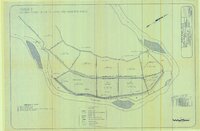
Lapoint Townsite - Hand Drawn Map
Image/StillImage
77
Ashley and Brush Creeks Dye Tests
1978
Image/StillImage
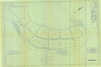
78
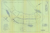
Plat of the Townsite of Randlett, Utah 1905
1905
Image/StillImage
79
Brush Creek and Pot Creek Distribution Systems
Image/StillImage
80
Plat of the Townsite of Avalon, Utah 1923
1923
Image/StillImage
81
Ouray Wildlife Refuge Scheme 3 - 1995 - Semi-Control of Flood Inflow to the Leota Odd-Numbered Ponds
1995
Image/StillImage
82
Ouray Wildlife Refuge Scheme 1 - 1995 - Natural Flood Inflow to Leota Odd-Numbered Ponds
1995
Image/StillImage
83
Ouray Wildlife Refuge Scheme 2 - 1995 - Semi-Natural Flood Inflows to Pond L-7
1995
Image/StillImage
84
Ouray Wildlife Refuge Scheme 5 - 1995 - Semi-Control of Flood Inflow to Pond L-7, Two Low Head Weirs
1995
Image/StillImage
85
Ouray Wildlife Refuge Scheme 6 - 1995 - Control of Flood Inflow to the Nursery Habitat
1995
Image/StillImage
86
Ouray Wildlife Refuge Scheme 4 - 1995 - Semi-Control of Flood Inflow to Pond L-7, One Low Head Weir
1995
Image/StillImage
87
Ouray Wildlife Refuge Exhibit 7 - 1995 - Improvement of Existing Main Canal Inlet
1995
Image/StillImage
88
Ouray SE, Utah 1999 - National Wetlands Inventory
1999
Image/StillImage
89
Ouray, Utah 1999 - National Wetlands Inventory
1999
Image/StillImage
90
Pelican Lake, Utah 1999 - National Wetlands Inventory
1999
Image/StillImage
91
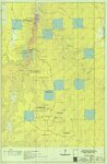
Brennan Basin Quad 1999 - National Wetlands Inventory
1999
Image/StillImage
92
Moon Lake Project Deserado Mine Sheet 1
1981
Image/StillImage
93
Moon Lake Project Deserado Mine Sheet 2
1981
Image/StillImage
94
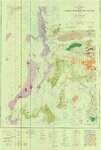
Map 68 Energy Resources Map of Utah 1983
1983
Image/StillImage
95
Grazing Service C.C.C. Range Surveys, 1927
1927
Image/StillImage
96
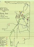
United States Civilian Conservation Corps - Vernal Camp - D6-31 Company 1507
1938
Image/StillImage
97
Map of a Reconnoissance between Fort Leavenworth on the Missouri River, and the Great Salt Lake in the Territory of Utah
1949; 1950
Image/StillImage
98
Bonneville Fuels Corp - Wolf Point Pipeline Project - Uintah County, Utah - Project Site Map
Image/StillImage
99
Critical Habitat Polygons for Penstemon Grahamii
Image/StillImage
100
Veritus Seismec Surveying and Positioning
Image/StillImage
76
-
100
of
474
<
1
2
3
4
5
6
7
8
9
10
>