|
|
Title | Collection Number And Name | Photo Number |
| 76 |
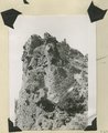 |
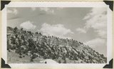
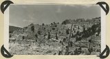
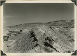
Brian Head formation at the 'Castles,' Castle Creek. Garfield County, UT, 1944 | P0013 Herbert E. Gregory Photograph Collection | P0013n12_073_2937 |
| 77 |
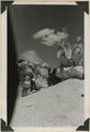 |
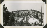
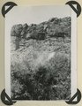
Brian Head formation at the 'Castles,' Castle Creek. Garfield County, UT, 1944. Details of erosion | P0013 Herbert E. Gregory Photograph Collection | P0013n12_074_2938 |
| 78 |
 |
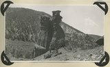
Brian Head formation capped by lava (rhyolite?): Cliff on upthrown side of Paunsaugunt fault. East fork of Sevier River near the mouth of Deer Creek. Garfield County, UT. 1943 | P0013 Herbert E. Gregory Photograph Collection | P0013n12_012_2859 |
| 79 |
 |
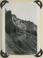
Brian Head formation in the walls of Panguitch Canyon near power house. Garfield County, UT. 1943 | P0013 Herbert E. Gregory Photograph Collection | P0013n12_019_2868 |
| 80 |
 |
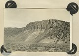
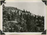
Brian Head formation underlain by pink Wasatch limestone on Highway 89, 2± miles north of Castle Creek. Garfield County, UT, 1944 | P0013 Herbert E. Gregory Photograph Collection | P0013n12_072_2934 |
| 81 |
 |
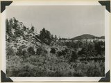
Brian Head formation, branch of Asay Creek; lies beneath basalt flows. Garfield County, UT, 1944 | P0013 Herbert E. Gregory Photograph Collection | P0013n12_072_2935 |
| 82 |
 |
Brian Head formation, consolidated (white wall) and disintegrated (upper slopes), and pink Wasatch limestones (lowest slopes). Seamans Canyon west of Gravel Pass. Kane County, UT, 1944 | P0013 Herbert E. Gregory Photograph Collection | P0013n12_071_2933 |
| 83 |
 |
Brian Head formation, consolidated (white wall) and disintegrated (upper slopes), and pink Wasatch limestones (lowest slopes). Seamans Canyon west of Gravel Pass. Kane County, UT, 1944 | P0013 Herbert E. Gregory Photograph Collection | P0013n12_071_2932 |
| 84 |
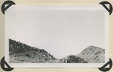 |
Burro Gap on East Fork of Sevier River above mouth of Deer Creek. Locus of Paunsaugunt fault; upthrow on east right. Garfield County, UT. 1943 | P0013 Herbert E. Gregory Photograph Collection | P0013n12_015_2862 |
| 85 |
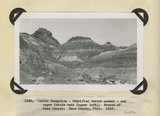 |
Chile formation, Petrified Forest member, and upper Chinle beds ( upper left). Branch of Road Canyon. Kane County, UT. 1943 | P0013 Herbert E. Gregory Photograph Collection | P0013n12_022_2872 |
| 86 |
 |
Chinle formation 2 miles northwest abandoned village of Paria. Kane County, UT. 1943 | P0013 Herbert E. Gregory Photograph Collection | P0013n12_023_2874 |
| 87 |
 |
Chinle formation, Petrified Forest member. Head of Fossil Wood Creek. Kane County, UT. 1943 | P0013 Herbert E. Gregory Photograph Collection | P0013n12_022_2873 |
| 88 |
 |
Chinle formation, upper red beds capped by remnants of Wingate sandstone. Five Pines Wash. Kane County, UT. 1943 | P0013 Herbert E. Gregory Photograph Collection | P0013n12_024_2876 |
| 89 |
 |
Chinle formation, upper red beds near mouth of Box Elder Canyon. Kane County, UT. 1943 | P0013 Herbert E. Gregory Photograph Collection | P0013n12_024_2875 |
| 90 |
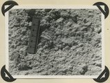 |
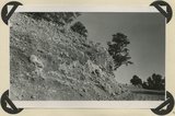
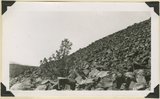
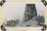
Detailed view of pumice conglomerate in the Brian Head formation, Casto Bluff, Garfield County, UT, 1943 | P0013 Herbert E. Gregory Photograph Collection | P0013n12_017_2864 |
| 91 |
 |
Detailed view of pumice conglomerate in the Brian Head formation, Casto Bluff, Garfield County, UT, 1943 | P0013 Herbert E. Gregory Photograph Collection | P0013n12_013_2860 |
| 92 |
 |
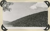
End of basalt flow in Black Rock Valley. White rocks (foreground) and left sky line (Haycock Mountain) of Brian Head formation. Garfield County, UT, 1944 | P0013 Herbert E. Gregory Photograph Collection | P0013n12_077_2942 |
| 93 |
 |
End of basalt flow in Black Rock Valley. White rocks (foreground) and left sky line (Haycock Mountain) of Brian Head formation. Garfield County, UT, 1944 | P0013 Herbert E. Gregory Photograph Collection | P0013n12_078_2943 |
| 94 |
 |
End of recent basalt flow at the race track, Panguitch Lake. Garfield County, UT, 1943 | P0013 Herbert E. Gregory Photograph Collection | P0013n12_021_2871 |
| 95 |
 |
Entrada sandstone, regular bedded shaly phase overlain by undifferentiated Curtis and Winsor formations. Antimony Canyon, Garfield County, UT, 1943 | P0013 Herbert E. Gregory Photograph Collection | P0013n12_011_2856 |
| 96 |
 |
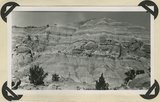
Eroded flank of the East Kaibab monocline at the junction of Paria River and Cottonwood Creek (left center). The sequence is Navajo (left), upper Jurassic (largely eroded), Dakota, Tropic, and Straight Cliffs. Kane County, UT, 1944 | P0013 Herbert E. Gregory Photograph Collection | P0013n12_040_2887 |
| 97 |
 |
Erosion features in Entrada sandstone. Antimony Canyon, Garfield County, UT, 1943 | P0013 Herbert E. Gregory Photograph Collection | P0013n12_011_2857 |
| 98 |
 |
Erosion features in Entrada sandstone. Antimony Canyon, Garfield County, UT, 1943 | P0013 Herbert E. Gregory Photograph Collection | P0013n12_012_2858 |
| 99 |
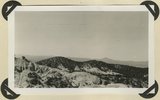 |
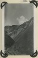
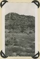
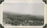
Erosion surface developed on Brian Head formation; downthrow side of Sevier fault. Rim of Sevier Plateau on skyline. Limekiln Gulch, Garfield County, UT, 1942 | P0013 Herbert E. Gregory Photograph Collection | P0013n12_004_2851 |
| 100 |
 |
Escalante Canyon 2 miles below Big Bend. Walls of Navajo sandstone 800 feet high. Garfield, UT, 1944 | P0013 Herbert E. Gregory Photograph Collection | P0013n12_056_2908 |