|
|
Title | Collection Number And Name | Photo Number |
| 76 |
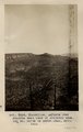 |
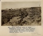
Monocline, LaPlata over Dolores east face of Skeleton Mesa, 15+ mi. north of Marsh Pass, Ariz., 1910 | P0013 Herbert E. Gregory Photograph Collection | P0013n04_30_0566 |
| 77 |
 |
Monocline, LaPlata over Dolores east face of Skeleton Mesa, 15± mi. north of Marsh Pass, Ariz., 1910 (Photo G154) | P0013 Herbert E. Gregory Photograph Collection | P0013n04_30_0566 |
| 78 |
 |
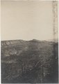
Marsh Pass, Ariz., looking northeast, LaPlata sandstone dipping southeast under Black Mesa (Photo G155) | P0013 Herbert E. Gregory Photograph Collection | P0013n04_31_0567 |
| 79 |
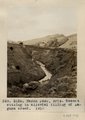 |
Marsh Pass, Ariz. Recent cutting in alluvial filling of Laguna Creek, 1910 (Photo G156) | P0013 Herbert E. Gregory Photograph Collection | P0013n04_31_0568 |
| 80 |
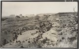 |
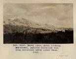
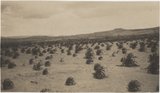
General view of upper Moencopie strata, looking northeast toward Monument Pass. Taken from a point 8± mi. northeast of Agathla Needle, Ariz., 1910 (Photo G158) | P0013 Herbert E. Gregory Photograph Collection | P0013n04_32_0560A |
| 81 |
 |
General view of upper Moencopie strata, looking northeast toward Monument Pass. Taken from a point 8+ mi. northeast of Agathla Needle, Ariz., 1910 (Photo G158) | P0013 Herbert E. Gregory Photograph Collection | P0013n04_32_0560a |
| 82 |
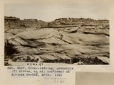 |
Cross-bedding, Moencopie (?) strata, 6+ mi. northeast of Agathla Needle, Ariz., 1910 (Photo G157) | P0013 Herbert E. Gregory Photograph Collection | P0013n04_32_0569 |
| 83 |
 |
Cross-bedding, Moencopie (?) strata, 6± mi. northeast of Agathla Needle, Ariz., 1910 (Photo G157) | P0013 Herbert E. Gregory Photograph Collection | P0013n04_32_0569 |
| 84 |
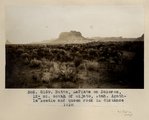 |
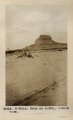
Butte, LaPlata on Dolores, 12+ mi. south of Oljato, Utah. Agathla Needle and QueenRock in distance, 1910 (Photo G159) | P0013 Herbert E. Gregory Photograph Collection | P0013n04_33_0561a |
| 85 |
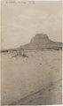 |
Butte, LaPlata on Dolores, 12± mi. south of Oljato, Utah. Agathla Needle in distance, 1910 | P0013 Herbert E. Gregory Photograph Collection | P0013n04_33_0562A |
| 86 |
 |
Butte, LaPlata on Dolores, 12+ mi. south of Oljato, Utah. Agathla Needle in distance, 1910 (Photo N-M91A) | P0013 Herbert E. Gregory Photograph Collection | P0013n04_33_0562a |
| 87 |
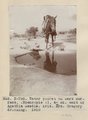 |
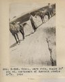
Water pocket on bare surface (Moencopie?), 4+ mi. east of Agathla Needle, Ariz. Mrs. Gregory drinking, 1910 (Photo N-M92) | P0013 Herbert E. Gregory Photograph Collection | P0013n04_34_0563a |
| 88 |
 |
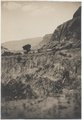
Navajo dry farming, Laguna Creek valley near Marsh Pass, Ariz., 1910 (Photo G160) | P0013 Herbert E. Gregory Photograph Collection | P0013n04_34_0564A |
| 89 |
 |
Navajo dry farming, Laguna Creek valley near Marsh Pass, Ariz., 1910 (Photo G160) | P0013 Herbert E. Gregory Photograph Collection | P0013n04_34_0564a |
| 90 |
 |
Camp 3+ mi. east of Agathla Needle, Ariz. (Photo N-M93) | P0013 Herbert E. Gregory Photograph Collection | P0013n04_34_0565a |
| 91 |
 |
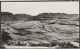
Trail, bare rock, angle 30 degrees, 10+ mil. northeast of Agathla Needle (Photo N-M94) | P0013 Herbert E. Gregory Photograph Collection | P0013n04_35_0566a |
| 92 |
 |
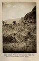
Butte, junction Sagy canyon with middle of East Branch, Ariz., 1910 (Photo G162) | P0013 Herbert E. Gregory Photograph Collection | P0013n04_35_0567a |
| 93 |
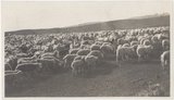 |
Navajo sheep, near Agathla Needle, Ariz., 1910 (Photo G161) | P0013 Herbert E. Gregory Photograph Collection | P0013n04_35_0568A |
| 94 |
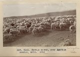 |
Navajo sheep, near Agathla Needle, Ariz., 1910 (Photo G161) | P0013 Herbert E. Gregory Photograph Collection | P0013n04_35_0568a |
| 95 |
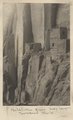 |
Betatakin Ruin, Sagy Canyon (Townsend photo) | P0013 Herbert E. Gregory Photograph Collection | P0013n04_35verso_0569a |
| 96 |
 |
Recent cutting in Sagy Canyon (Towanaoche) Ariz., 1910 (Photo G163) | P0013 Herbert E. Gregory Photograph Collection | P0013n04_36_0570 |
| 97 |
 |
Recent cutting in Sagy Canyon (Towanaoche) Ariz., 1910 (Photo G163) | P0013 Herbert E. Gregory Photograph Collection | P0013n04_36_0570 |
| 98 |
 |
Keet Seel, Segi Canyon, Navajo Reservation (J.D.L. VerPlank photo) | P0013 Herbert E. Gregory Photograph Collection | P0013n04_36verso_0571 |
| 99 |
 |
General view, Sagy (Towanaoche) Canyon, Ariz., LaPlata strata (C.R. Jefferis photo) | P0013 Herbert E. Gregory Photograph Collection | P0013n04_37_0572 |
| 100 |
 |
Shanto Springs (photograph from Herbert E. Gregory Book 4: Navajo, San Juan, 1910) | P0013 Herbert E. Gregory Photograph Collection | P0013n04_37_0573 |