TO
| Title | Date | Type | Setname | ||
|---|---|---|---|---|---|
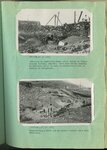
| 51 |
 |
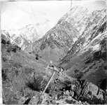
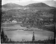
Kessler Canyon barrier spillway : looking up stream from Garfield smelter at series of control structures in Kessler Canyon [and] Looking down stream across site of main barrier spillway, Kessler Canyon, during construction | 1923; 1924; 1925; 1926; 1927; 1928; 1929; 1930; 1931; 1932; 1933 | Image/StillImage | uum_map |
| 52 |
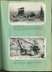 |
Kessler Canyon barrier spillway : Lifting boulders out of the ground for use in building main spillway, Kessler Canyon [and] Boulders being placed by heavy derrick, in foundation of main spillway, Kessler Canyon | 1923; 1924; 1925; 1926; 1927; 1928; 1929; 1930; 1931; 1932; 1933 | Image/StillImage | uum_map |
| 53 |
 |
Kessler Canyon barrier spillway looking downstream toward Garfield smelter [and] The same after a forrential flood which reached a depth of 7 feet over the 70 foot crest | 1923; 1924; 1925; 1926; 1927; 1928; 1929; 1930; 1931; 1932; 1933 | Image/StillImage | uum_map |
| 54 |
 |
Kessler Canyon barrier spillway : building an equalizing check above intake to tunnel through Garfield Smelter [and] Constructing a check dam in Kessler Canyon below main structure | 1923; 1924; 1925; 1926; 1927; 1928; 1929; 1930; 1931; 1932; 1933 | Image/StillImage | uum_map |
| 55 |
 |
Kessler Canyon barrier spillway : looking down stream from main spillway, Kessler Canyon [and] Detail of rubble-concrete construction | 1923; 1924; 1925; 1926; 1927; 1928; 1929; 1930; 1931; 1932; 1933 | Image/StillImage | uum_map |
| 56 |
 |
Kessler Canyon barrier spillway : Guniting a rubble-concrete wing wall, Kessler Canyon [and] Gasoline driven shovel building the flood barrier, Kessler Canyon | 1923; 1924; 1925; 1926; 1927; 1928; 1929; 1930; 1931; 1932; 1933 | Image/StillImage | uum_map |
| 57 |
 |
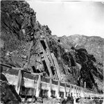
Kessler Canyon barrier spillway : spillway through man barrier, Kessler Canyon [and] The flood stream drops over a circular crest into a stilling pond | 1923; 1924; 1925; 1926; 1927; 1928; 1929; 1930; 1931; 1932; 1933 | Image/StillImage | uum_map |
| 58 |
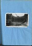 |
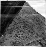
Kessler Canyon main spillway structure | 1923; 1924; 1925; 1926; 1927; 1928; 1929; 1930; 1931; 1932; 1933 | Image/StillImage | uum_map |
| 59 |
 |
Robert Hinckley and Judy Lund at the Utah State Capitol | 1958; 1959; 1960; 1961 | Image/StillImage | uum_map |
| 60 |
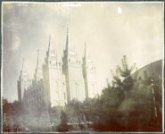 |
Salt Lake Temple | 1900; 1901; 1902; 1903; 1904; 1905; 1906; 1907; 1908; 1909; 1910; 1911; 1912; 1913; 1914; 1915; 1916; 1917; 1918; 1919; 1920 | Image/StillImage | uum_map |
| 61 |
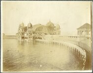 |
Saltair pavilion and pier | 1900; 1901; 1902; 1903; 1904; 1905; 1906; 1907; 1908; 1909; 1910; 1911; 1912; 1913; 1914; 1915; 1916; 1917; 1918; 1919; 1920 | Image/StillImage | uum_map |
| 62 |
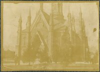 |
Assembly Hall, Temple Square | 1900; 1901; 1902; 1903; 1904; 1905; 1906; 1907; 1908; 1909; 1910; 1911; 1912; 1913; 1914; 1915; 1916; 1917; 1918; 1919; 1920 | Image/StillImage | uum_map |
| 63 |
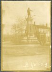 |
Brigham Young statue | 1900; 1901; 1902; 1903; 1904; 1905; 1906; 1907; 1908; 1909; 1910; 1911; 1912; 1913; 1914; 1915; 1916; 1917; 1918; 1919; 1920 | Image/StillImage | uum_map |
| 64 |
 |
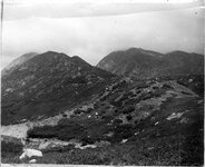
Dip and strike of Cambrian shales, slates and quartzite, Big Cottonwood Canyon | 1910; 1911; 1912; 1913; 1914; 1915; 1916; 1917; 1918; 1919; 1920; 1921; 1922; 1923; 1924; 1925; 1926; 1927; 1928; 1929; 1930; 1931; 1932; 1933; 1934; 1935; 1936; 1937; 1938; 1939; 1940; 1941; 1942; 1943; 1944; 1945 | Image/StillImage | uum_map |
| 65 |
 |
Stratification of Cambrian quartzite and shales, Big Cottonwood Canyon | 1910; 1911; 1912; 1913; 1914; 1915; 1916; 1917; 1918; 1919; 1920; 1921; 1922; 1923; 1924; 1925; 1926; 1927; 1928; 1929; 1930; 1931; 1932; 1933; 1934; 1935; 1936; 1937; 1938; 1939; 1940; 1941; 1942; 1943; 1944; 1945 | Image/StillImage | uum_map |
| 66 |
 |
Stratified shales and slates, Big Cottonwood Canyon [02] | 1910; 1911; 1912; 1913; 1914; 1915; 1916; 1917; 1918; 1919; 1920; 1921; 1922; 1923; 1924; 1925; 1926; 1927; 1928; 1929; 1930; 1931; 1932; 1933; 1934; 1935; 1936; 1937; 1938; 1939; 1940; 1941; 1942; 1943; 1944; 1945 | Image/StillImage | uum_map |
| 67 |
 |
Stratified slates showing dip, above flume in Big Cottonwood | 1910; 1911; 1912; 1913; 1914; 1915; 1916; 1917; 1918; 1919; 1920; 1921; 1922; 1923; 1924; 1925; 1926; 1927; 1928; 1929; 1930; 1931; 1932; 1933; 1934; 1935; 1936; 1937; 1938; 1939; 1940; 1941; 1942; 1943; 1944; 1945 | Image/StillImage | uum_map |
| 68 |
 |
Clayton Peak, Brighton | 1910; 1911; 1912; 1913; 1914; 1915; 1916; 1917; 1918; 1919; 1920; 1921; 1922; 1923; 1924; 1925; 1926; 1927; 1928; 1929; 1930; 1931; 1932; 1933; 1934; 1935; 1936; 1937; 1938; 1939; 1940; 1941; 1942; 1943; 1944; 1945 | Image/StillImage | uum_map |
| 69 |
 |
Cambrian slates at bottom of Big Cottonwood Canyon | 1910; 1911; 1912; 1913; 1914; 1915; 1916; 1917; 1918; 1919; 1920; 1921; 1922; 1923; 1924; 1925; 1926; 1927; 1928; 1929; 1930; 1931; 1932; 1933; 1934; 1935; 1936; 1937; 1938; 1939; 1940; 1941; 1942; 1943; 1944; 1945 | Image/StillImage | uum_map |
| 70 |
 |
Stratified shales and slates, Big Cottonwood Canyon [01] | 1910; 1911; 1912; 1913; 1914; 1915; 1916; 1917; 1918; 1919; 1920; 1921; 1922; 1923; 1924; 1925; 1926; 1927; 1928; 1929; 1930; 1931; 1932; 1933; 1934; 1935; 1936; 1937; 1938; 1939; 1940; 1941; 1942; 1943; 1944; 1945 | Image/StillImage | uum_map |
| 71 |
 |
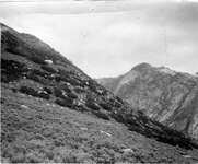
Morainic mass extending across Little Cottonwood Canyon | 1910; 1911; 1912; 1913; 1914; 1915; 1916; 1917; 1918; 1919; 1920; 1921; 1922; 1923; 1924; 1925; 1926; 1927; 1928; 1929; 1930; 1931; 1932; 1933; 1934; 1935; 1936; 1937; 1938; 1939; 1940; 1941; 1942; 1943; 1944; 1945 | Image/StillImage | uum_map |
| 72 |
 |
Fault scarp crossing south moraine of Little Cottonwood Canyon | 1910; 1911; 1912; 1913; 1914; 1915; 1916; 1917; 1918; 1919; 1920; 1921; 1922; 1923; 1924; 1925; 1926; 1927; 1928; 1929; 1930; 1931; 1932; 1933; 1934; 1935; 1936; 1937; 1938; 1939; 1940; 1941; 1942; 1943; 1944; 1945 | Image/StillImage | uum_map |
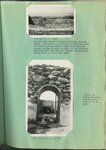
| 73 |
 |
Perched, granite boulders on quartzite formation, Little Cottonwood Canyon | 1910; 1911; 1912; 1913; 1914; 1915; 1916; 1917; 1918; 1919; 1920; 1921; 1922; 1923; 1924; 1925; 1926; 1927; 1928; 1929; 1930; 1931; 1932; 1933; 1934; 1935; 1936; 1937; 1938; 1939; 1940; 1941; 1942; 1943; 1944; 1945 | Image/StillImage | uum_map |
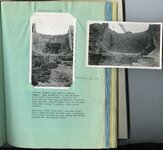
| 74 |
 |
Bonneville and intermediate shore lines near mouth of Dry Canyon | 1910; 1911; 1912; 1913; 1914; 1915; 1916; 1917; 1918; 1919; 1920; 1921; 1922; 1923; 1924; 1925; 1926; 1927; 1928; 1929; 1930; 1931; 1932; 1933; 1934; 1935; 1936; 1937; 1938; 1939; 1940; 1941; 1942; 1943; 1944; 1945 | Image/StillImage | uum_map |
| 75 |
 |
Contact between archaean quartzite and granite, south side of Little Cottonwood Canyon | 1910; 1911; 1912; 1913; 1914; 1915; 1916; 1917; 1918; 1919; 1920; 1921; 1922; 1923; 1924; 1925; 1926; 1927; 1928; 1929; 1930; 1931; 1932; 1933; 1934; 1935; 1936; 1937; 1938; 1939; 1940; 1941; 1942; 1943; 1944; 1945 | Image/StillImage | uum_map |