TO
Filters: Collection: "ir_etd" Type: "Image"
| Author | Title | Subject | Date | Publication Type | ||
|---|---|---|---|---|---|---|
| 51 |
 |
Rodriguez, Enrique Levy | Economic geology of the sulphur deposits at Sulphurdale, Utah: Georeferenced map files | Geology, Economic -- Utah -- Sulphurdale; Mines and mineral resources -- Utah -- Sulphurdale; Sulphur mines and mining -- Utah -- Sulphurdale | 1960-08 | thesis |
| 52 |
|
Brooke, John Percival | Alteration and trace elements of volcanics in the San Francisco Mountains: Georeferenced map files | Thesis and dissertation georeferencing project | 1964-06 | thesis |
| 53 |
|
Stifel, Peter Beekman | Geology of the Terrace and Hogup Mountains, Box Elder County, Utah: Georeferenced map files | Geology -- Utah -- Box Elder County | 1964-06 | thesis |
| 54 |
|
Gross, Larry T. | Stratigraphic analysis of the Mesaverde Group, Uinta Basin, Utah: Georeferenced map files | Geology; Stratigraphic; Cretaceous; Uinta Basin (Utah and Colo.) | 1961-05 | thesis |
| 55 |
|
Vlam, Heber Adolf Arien | Petrology of Lake Bonneville Gravels Salt Lake County, Utah: Georeferenced map files | Petrology; Utah; Salt Lake County; Bonneville; Lake | 1963-05 | thesis |
| 56 |
|
Slentz, Loren William | Tertiary Salt Lake group in the Great Salt Lake Basin: Georeferenced map files | Geology; Stratigraphic; Tertiary; Utah; Great Salt Lake Basin | 1955-07 | thesis |
| 57 |
|
Earll, Fred Nelson | Geology of the Central Mineral Range, Beaver County, Utah: Georeferenced map files | Geology -- Utah -- Mineral Mountains; Beaver County | 1957-08 | thesis |
| 58 |
|
Groenewold, Bernard Cyrus | Subsurface geology of the Mesozoic formations overlying the Uncompahgre Uplift in Grand County, Utah: Georeferenced map files | Geology; Utah; Grand County; Stratigraphic; Mesozoic | 1961-06 | thesis |
| 59 |
|
Anderson, Warren L. | Geology of the northern Silver Island Mountains, Box Elder and Tooele Counties, Utah: Georeferenced maps | Geology; Utah; Silver Island Mountains | 1957-06 | thesis |
| 60 |
|
O'Toole, Walter L. | Geology of the Keetley-Kamas volcanic area: Georeferenced map files | Geology; Utah; Summit County; Wasatch County | 1951 | thesis |
| 61 |
|
Eriksson, Yves | Geology of the upper Ogden Canyon, Weber County, Utah: Georeferenced map files | Geology -- Utah -- Weber County | 1960-06 | thesis |
| 62 |
|
Morris, Elliot Cobia | Geology of the Big Piney area, Summit County, Utah: Georeferenced map files | Geology -- Utah -- Summit County | 1953-06 | thesis |
| 63 |
|
Condie, Kent C. | Petrogeneis of the Mineral Range Pluton, Southwestern Utah: Georeferenced map files | Petrology -- Utah -- Beaver County; Millard County; Geology -- Utah -- Beaver County; Millard County; Mineral Range (Utah) | 1960-06 | thesis |
| 64 |
|
Doelling, Hellmut H. | Geology of the Northern Lakeside Mountains and the Grassy Mountains and vicinity, Tooele and Box Elder Counties, Utah: Georeferenced map files | Geology -- Utah -- Tooele County; Geology -- Utah -- Box Elder County; Geology -- Utah -- Grassy Mountains -- Maps; Geology -- Utah -- Lakeside Mountains -- Maps | 1964-06 | thesis |
| 65 |
|
Temple, Dennis Charles | Mount Ogden granite: Georeferenced map files | Granite; Utah; Mount Ogden; Geology; Stratigraphic; Precambrian ; Rocks; Crystalline; Metamorphic | 1969-06 | thesis |
| 66 |
 |
Morris, Elliot Cobia | Map 1 Geologic map and sections of Big Piney Area, Utah (Google Earth map overlay KMZ file) | Geology -- Utah -- Summit County | 1953-06 | thesis |
| 67 |
|
Mount, Donald Lee | Plate 3: Geologic map and sections of Wanship-Park City region, Utah (Google Earth map overlay KMZ file) | Geology -- Utah -- Summit County | 1952-06 | thesis |
| 68 |
|
Temple, Dennis Charles | Plates 2-3 Geologic map of the Mount Ogden granite, Weber County, Utah and Geologic sections to accompany the Geologic map of the Mount Ogden granite, Weber County, Utah (Google Earth map overlay KMZ file) | Granite; Utah; Mount Ogden; Geology; Stratigraphic; Precambrian ; Rocks; Crystalline; Metamorphic; Thesis and dissertation georeferencing project | 1969-06 | thesis |
| 69 |
|
Blue, Donald McCoy | Plate 1: Lucin mining district and vicinity, Northern Pilot Range, Box Elder County, Utah - Elko County, Nevada (Google Earth map overlay KMZ file) | Thesis and dissertation georeferencing project | 1960-08 | thesis |
| 70 |
|
Condie, Kent C. | Map 1 Geologic map of the Mineral Range, Utah (Google Earth map overlay KMZ file) | Petrology -- Utah -- Beaver County; Millard County; Geology -- Utah -- Beaver County; Millard County; Mineral Range (Utah); Thesis and dissertation georeferencing project | 1960-06 | thesis |
| 71 |
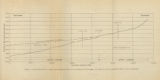 |
Gates, Joseph S. | Figure 4: Longitudinal profile of Middle Canyon showing locations of the profiles across the canyon, the nickpoint, and the hypothetical profile before rejuvenation | Thesis and dissertation georeferencing project | 1960-08 | thesis |
| 72 |
|
Neff, Thomas Rodney | Petrology and structure of the little willow series, Wasatch Mountains, Utah: Georeferenced map files | Petrology -- Utah -- Wasatch Mountains | 1962-11 | thesis |
| 73 |
|
Schaeffer, Jr. Frederick Ernst | Geology of the Central and Southern Silver Island Mountains Tooele County, Utah and Elko County, Nevada: Georeferenced map files | 1961-06 | thesis | |
| 74 |
 |
Brox, George Stanley | Plate 1: Geologic map of Northern Bryce Canyon National Park | 1961-06 | thesis | |
| 75 |
|
Hooper, Warren G. | Geology of the Smith and Morehouse-South Fork Area, Utah: Georeferenced map files | Geology -- Uinta Mountains (Utah and Wyo.) | 1951 | thesis |