Home
Browse
Ask Us
Chat
Harmful Language Statement
Log in
Photo Archives
Advanced Search
About
Over 70,000 photos covering a variety of topics from Marriott Library Special Collections
Year
1921
1922
1923
1924
1925
1926
1927
1928
1929
1930
1931
1932
1933
TO
1921
1922
1923
1924
1925
1926
1927
1928
1929
1930
1931
1932
1933
Type
Image/StillImage
59
Format
image/jpeg
59
Collection Name
Utah Flood Survey
59
Filters:
Collection Name:
"Utah Flood Survey"
Collection:
"uum_map"
Type:
"Image/StillImage"
Format:
"image/jpeg"
51
-
75
of
59
<
1
2
3
>
Gallery view
Number of results to display per page
10
25
50
100
200
Sort by Relevance
Sort by Title A-Z
Sort by Title Z-A
Sort by Date Ascending
Sort by Date Descending
Sort by Last Modified Ascending
Sort by Last Modified Descending
Sort by Photo Number
Title
Collection Number And Name
Photo Number
51
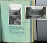
Kessler Canyon barrier spillway : spillway through man barrier, Kessler Canyon [and] The flood stream drops over a circular crest into a stilling pond
P0208 Utah Flood Survey photograph collection
P0208n01_01_098-099
52
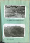
Erosion of foot hills near Bountiful, showing goat herd which grazes over the Bountiful water-shed [and] Near the crest of the Davis County water-shed where floods originate
P0208 Utah Flood Survey photograph collection
P0208n01_01_100-101
53
Haights Creek Diversion dam in process of construction
P0208 Utah Flood Survey photograph collection
P0208n01_01_102
54
Chalk Creek before control, looking up stream during period of highwater in spring, when stream was carrying large quantities of gravel [and] Looking up stream across north end of Fillmore barrier, first season of operation
P0208 Utah Flood Survey photograph collection
P0208n01_01_103-104
55
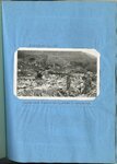
Farmington, August 1924, commencement of spillway and barrier
P0208 Utah Flood Survey photograph collection
P0208n01_01_105-106
56
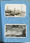
Looking down Cottonwood Creek at Farmington after flood of 1922 and before barrier construction [and] Farmington spillway, first season of operation
P0208 Utah Flood Survey photograph collection
P0208n01_01_107-108
57
Farmington spillway before first season of operation
P0208 Utah Flood Survey photograph collection
P0208n01_01_109
58
Enterprise flood dam in process of construction
P0208 Utah Flood Survey photograph collection
P0208n01_01_110
59
Kessler Canyon main spillway structure
P0208 Utah Flood Survey photograph collection
P0208n01_01_111
51
-
75
of
59
<
1
2
3
>