|
|
Title | Collection Number And Name | Photo Number |
| 51 |
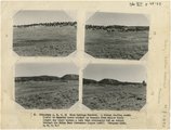 |
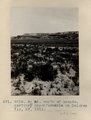
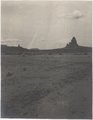
(Panorama A, B, C, D) Blue Springs Meadows. A stream leading south (left) to Mammoth Creek blocked by basalts from Miller Knoll (right sky line) became a lake that eventuallly cut an outlet through the Brian Head formation (upper left). | P0013 Herbert E. Gregory Photograph Collection | P0013n12_068-069_2929ABCD |
| 52 |
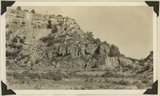 |
1, Navajo sandstone (at base); 2, shales; 3, sandstone bed that forms "entablatures" on "Temples" of Zion National Park; 4, Carmel and above. Zion-Mount Carmel highway, Kane County, Utah, 1931. | P0013 Herbert E. Gregory Photograph Collection | P0013n10_085_2229 |
| 53 |
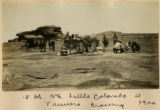 |
15 Miles NE Little Colorado at Tanners Crossing 1900 | P0013 Herbert E. Gregory Photograph Collection | P0013n01_38_098 |
| 54 |
 |
Indurated red fanglomerate lying against fault that crosses Cafe Spring wash at a point 5 miles below Cave Spring; 1696. | P0013 Herbert E. Gregory Photograph Collection | P0013n08_180_1695 |
| 55 |
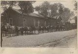 |
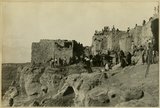
20 mules in a train | P0013 Herbert E. Gregory Photograph Collection | P0013n03_12verso_0383 |
| 56 |
 |
3± mi. north of Ganado, Ariz. Tertiary in angular unconformity with Dolores (Triassic), 1909 (photo G-37) | P0013 Herbert E. Gregory Photograph Collection | P0013n02_026_243 |
| 57 |
 |
3± mi. north of Ganado. Tertiary unconformable on Dolores. VII, 19. 1911 (Photo G218) | P0013 Herbert E. Gregory Photograph Collection | P0013n05_27_0712 |
| 58 |
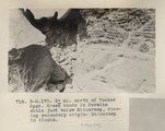 |
3± mi. north of Tucker Spgs. Green bands in Permian shale just below Shinarump, showing secondary origin. Shinarump in blocks (Photo N-M170) | P0013 Herbert E. Gregory Photograph Collection | P0013n06_070_0966 |
| 59 |
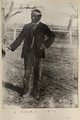 |
A Navajo 1910 | P0013 Herbert E. Gregory Photograph Collection | P0013n03_24verso_0407 |
| 60 |
 |
A basin range, Toquerville region, 190 | P0013 Herbert E. Gregory Photograph Collection | P0013n01_50_148 |
| 61 |
 |
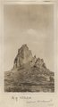
A nearer view of G-48 (volcanic neck between Sunrise Springs and Biddehoche), 1909 (photo G-49) | P0013 Herbert E. Gregory Photograph Collection | P0013n02_031_255 |
| 62 |
 |
A. M. Thompson, Kanab Creek, 1872. | P0013 Herbert E. Gregory Photograph Collection | P0013n10_220_2485 |
| 63 |
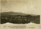 |
Abajo Mountains from southwest, [Probably from southern end of Elk Ridge] | P0013 Herbert E. Gregory Photograph Collection | P0013n08_039_1385 |
| 64 |
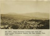 |
Abajo Mountains looking east from Elk Ridge across Cottonwood Canyon, San Juan County, Utah. June, 1915. | P0013 Herbert E. Gregory Photograph Collection | P0013n08_035_1377 |
| 65 |
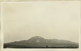 |
Abajo Mountains looking northwest from Blanding. Monticello Road. San Juan County, UT, 1928 | P0013 Herbert E. Gregory Photograph Collection | P0013n09_120_1953 |
| 66 |
 |
Abancay to La Estrella. Concacha. Nearer view of the same. | P0013 Herbert E. Gregory Photograph Collection | P0013n13_065_9-3074 |
| 67 |
 |
Abandoned Logan, San Juan River, 10 miles above mouth | P0013 Herbert E. Gregory Photograph Collection | P0013n09_154_2012 |
| 68 |
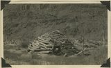 |
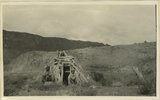
Abandoned hogan on east side of the San Juan some 3 miles above the mouth of Pinte Creek. San Juan County, UT. 1921 | P0013 Herbert E. Gregory Photograph Collection | P0013n09_196_2082 |
| 69 |
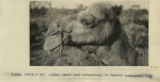 |
Afghan camel used extensively in central Australia, 1916 | P0013 Herbert E. Gregory Photograph Collection | P0013n13_102_9-3171 |
| 70 |
 |
After the dance, Walpi, AZ | P0013 Herbert E. Gregory Photograph Collection | P0013n08_050_1398 |
| 71 |
 |
Agathla (John Wetherill photo) | P0013 Herbert E. Gregory Photograph Collection | P0013n04_22verso_0551 |
| 72 |
 |
Agathla and Slim (Queen) Rock, Ariz., from S.E. (Photo G144) | P0013 Herbert E. Gregory Photograph Collection | P0013n04_21_0548 |
| 73 |
 |
Agathla and Slim (Queen) Rock, Ariz., from S.E. (Photo G144) | P0013 Herbert E. Gregory Photograph Collection | P0013n04_21_0548 |
| 74 |
 |
Agathla and Slim (Queen) Rock, Ariz., from S.E. (Photo N-M86) | P0013 Herbert E. Gregory Photograph Collection | P0013n04_20_0547 |
| 75 |
 |
Agathla, volcanic neck, between Chinlee, Ariz. and Oljato, Utah, 1910 (Photo G145) | P0013 Herbert E. Gregory Photograph Collection | P0013n04_21_0549 |