Home
Browse
Ask Us
Chat
Harmful Language Statement
Log in
Photo Archives
Advanced Search
About
Over 70,000 photos covering a variety of topics from Marriott Library Special Collections
Year
1930
1931
1932
1933
1934
1935
1936
1937
1938
1939
1940
1941
1942
1943
1944
1945
1946
1947
1948
1949
1950
1951
1952
1953
1954
1955
1956
1957
1958
1959
1960
1961
1962
1963
1964
1965
1966
1967
1968
1969
1970
TO
1930
1931
1932
1933
1934
1935
1936
1937
1938
1939
1940
1941
1942
1943
1944
1945
1946
1947
1948
1949
1950
1951
1952
1953
1954
1955
1956
1957
1958
1959
1960
1961
1962
1963
1964
1965
1966
1967
1968
1969
1970
Type
Image
100
Format
image/jpeg
100
Collection
Photo Archives
100
Filters:
Collection Name:
"Environmental Geology in Utah"
Type:
"Image"
51
-
75
of
100
<
1
2
3
4
>
Gallery view
Number of results to display per page
10
25
50
100
200
Sort by Relevance
Sort by Title A-Z
Sort by Title Z-A
Sort by Date Ascending
Sort by Date Descending
Sort by Last Modified Ascending
Sort by Last Modified Descending
Title
Date
Type
51
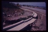
Damage to newly laid curb and gutter on Salt Lake City's East Bench, resulting from August 1969 cloudburst.
1969-08
Image
52
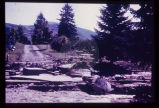
Damage to the Salt Lake City Cemetery from a flood channeled in Perry's Hollow, a normally dry drainage course.
Image
53
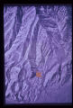
Aerial photograph showing same swath and slide as on topographic map. Arrow points to displaced mass from swath behind it in mountain range.
Image
54
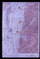
Ancient landslides show up on maps with scales as small as one inch to the mile. Three such ancient slides are pointed out along the mountain front in Juab County. Note swath of anomalous contours leading down to lowermost slide, obviously the path of bedrock which failed.
Image
55
Another example of dynamic forces at work in the geologic environment: pressure ridges formed in the salt crust of Utah's Bonneville Salt Flats. These ridges grow and shrink seasonally.
Image
56
Areas of carbonate rock (limestone) outcrops (in blue) in the vicinity of Bear Lake, Utah. Rocks range in age from Cambrian to Jurassic. Development on the outcrop area should be closely monitored to protect the underlying potable water aquifer.
Image
57
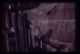
Arrow points to incipient failure of an excavation wall for a foundation for a multistory office building. Material is horizontally stratified Lake Bonneville silts and sands.
Image
58
Bear Lake area map showing: (1) point of issue of Swan Creek Spring, (2) possible contributory sink holes (in red) in the Bear River Range, (3) precipitation (rain and snow) measuring stations (in bluelined blocks).
Image
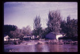
59
Big Cottonwood Creek flooding in Salt Lake City. Numerous houses along its banks were flooded in 1952.
1952
Image
60
Blasting for an interstate highway in the immediate vicinity of a dam. Concrete railing of dam appears in lower right corner. Vibrations, whether natural (earthquake) or manmade, may damage structures on sensitive foundations.
Image
61
Branch of the Wasatch Fault exposed in utility trench excavation in Salt Lake City. Hammer and field book are at the same stratigraphic horizon, indicating a displacement of 2 1/2 feet in late mudflow deposits, just below the ground surface.
Image
62
Breach of highway embankment on East Bench in Salt Lake City caused extensive damage to residential neighborhood downslope.
Image
63
Characteristic arcuate crack pattern in basement of house. Both vertical and lateral displacement is apparent.
Image
64
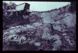
The circumstances here probably make a utility trench cave-in inevitable. A perched water table is sapping fine sand from underneath a thick silt bed, leaving the latter unsupported. Failure will be too rapid for escape of a workman who may be in the trench at the wrong moment.
Image
65
Closer view of head and foot of Park City landslide. Note tilt blocks at head of slide.
Image
66
Closer view of slide cracks in high fill in Salt Lake City subdivision. Note housing density downslope.
Image
67
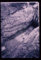
Closeup of slide plane. Note deposition of white calcium carbonate by groundwater along slide plane. Arrow points to smooth, slickensided (grooved) surface on underside of sliding mass.
Image
68
Closeup view of the fault shown in last slide (p1274n093).
Image
69
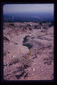
Cloudburst flood caused erosion of the North Bench in Salt Lake City. Eroded channel begins where paved street ends.
Image
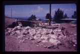
70
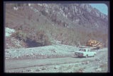
Cone or fan of debris deposited on highway after cloudburst flood in Big Cottonwood Canyon.
Image
71
Hydrograph depicting flow for the year 1945 of Utah's second largest spring, Swan Creek Spring, west of Bear Lake in northern Utah. Note the fluctuation in flow from April to September. Note also rapid response to spring snowmelt (April and May) and rainfall (June and July). The rock from which the spring issues (aquifer) is limestone. The graph illustrates the importance of controlling development on limestone terrain.
Image
72
In the same house; the ceiling is clearly distressed.
Image
73
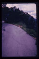
Incipient landslide failure on subdivision road. Note characteristic arcuate configuration of ground surface, also patching along crack.
Image
74
Landslide along a scarp of the East Bench Fault in Salt Lake City. No earth tremor is known to have triggered this slide, but an earthquake could trigger similar slides, given similar geologic conditions.
Image
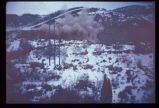
75
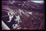
Landslide in Empire Canyon, Park City, in altered bedrock. Mining of metallic ores occurs just up the canyon. Park City lies just down-canyon. Switchbacks on road to Brighton have been wiped out; A further failure two years later took away even more of the hillside and dammed the creek in the canyon. Oblique aerial view.
Image
51
-
75
of
100
<
1
2
3
4
>