Home
Browse
Ask Us
Chat
Harmful Language Statement
Log in
Photo Archives
Advanced Search
About
Over 70,000 photos covering a variety of topics from Marriott Library Special Collections
Year
1930
1931
1932
1933
1934
1935
1936
1937
1938
1939
1940
1941
1942
1943
1944
1945
1946
1947
1948
1949
1950
1951
1952
1953
1954
1955
1956
1957
1958
1959
1960
1961
1962
1963
1964
1965
1966
1967
1968
1969
1970
TO
1930
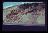
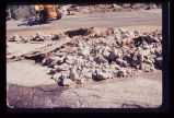
1931
1932
1933
1934
1935
1936
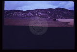
1937
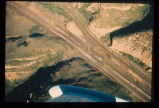
1938
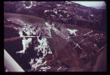
1939
1940
1941
1942
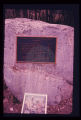
1943
1944
1945
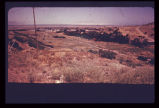
1946
1947
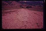
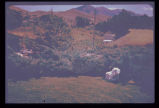
1948
1949
1950
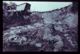
1951
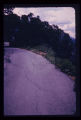
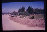
1952
1953
1954
1955
1956
1957
1958
1959
1960
1961
1962
1963
1964
1965
1966
1967
1968
1969
1970
Type
Image
100
Format
image/jpeg
100
Collection
Photo Archives
100
Filters:
Collection Name:
"Environmental Geology in Utah"
Format:
"image/jpeg"
Type:
"Image"
51
-
75
of
100
<
1
2
3
4
>
Gallery view
Number of results to display per page
10
25
50
100
200
Sort by Relevance
Sort by Title A-Z
Sort by Title Z-A
Sort by Date Ascending
Sort by Date Descending
Sort by Last Modified Ascending
Sort by Last Modified Descending
Title
Date
Type
51
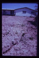
Incipient landslide failure on subdivision road. Note characteristic arcuate configuration of ground surface, also patching along crack.
Image
52
Landslide along a scarp of the East Bench Fault in Salt Lake City. No earth tremor is known to have triggered this slide, but an earthquake could trigger similar slides, given similar geologic conditions.
Image
53
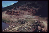
Landslide in Empire Canyon, Park City, in altered bedrock. Mining of metallic ores occurs just up the canyon. Park City lies just down-canyon. Switchbacks on road to Brighton have been wiped out; A further failure two years later took away even more of the hillside and dammed the creek in the canyon. Oblique aerial view.
Image
54
Landslide of bedrock onto highway; a frequent problem for highway maintenance, sometimes necessitating blasting of large bedrock blocks.
Image
55
Landslide scarp behind house along mountain front in Weber County.
Image
56
Landslide scarplet "getting closer to home" in mountain subdivision.
Image
57
Landsliding of an abutment encroaching on the reservoir which is near its peak stage (elevation). Structures for impoundment of flood waters must be sited with strict regard for geological conditions.
Image
58
Large scale landsliding during construction of Interstate 80 in Echo Canyon. Bedding plane slide.
Image
59
Leakage through the undisturbed abutment of an earthfill dam, measured in a wooden weir.
Image
60
Looking across a dam towards a massive ancient landslide. Recent highway construction has rejuvenated landsliding just below the spillway; note receding hillside under arrow.
Image
61
Looking downstream from the crest of the same earthfill dam (p1274n026). Note urban area at mouth of canyon.
Image
62
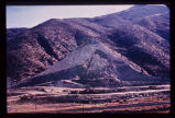
Low sun angle illumination, vertical aerial photograph of large ancient landslide in urban environment at mouth of Ogden Canyon.
Image
63
Map of Bear Lake showing bottom contours of the lake and depth to bedrock beneath soft valley sediments. The delta-fan areas along the east shore are colored yellow to indicate another hazard. Response of the delta-fan soft sediments to earthquake vibrations is anticipated to be poor, almost certainly causing severe damage to structures built on these level areas. Different earth materials may be expected to behave differently when shaken in an earthquake. The closeness of the contours bounding the delta-fans indicates a steep front for each. Movement of material in an earthquake may be expected to occur towards these steep fronts.
Image
64
Map of portion of the Wasatch Front showing the Wasatch Fault Zone in relation to the Salt Lake City aqueduct system (with water system facilities as projected into the 20th Century). Map illustrates severity of the earthquake problem in urban Utah.
Image
65
Map of Utah showing the 5 major active fault zones in the state.
Image
66
Monument to campers who lost their lives in cloudburst flood in Sheep Creek Canyon, in Flaming Gorge National Recreational Area, 1963. Note: boulder on which bronze monument has been placed is striated and polished by glacial action in the ice age.
Image
67
Mud-flow debris cleared from residence after storm on Salt Lake City's East Bench.
Image
68
Mud-flow which occurred in same season in which photo was taken, in Tooele County. Cloudburst probably descended on the background watershed in the Oquirrh Range.
Image
69
Mud-rock flow from upper steep-walled tributary canyon into Echo Canyon (Summit County) and over Interstate 80. Note that one lane of traffic has been cleared of debris. Aerial photo July 1968.
1968-07
Image
70
Multistory apartment house sitting astride the East Bench Fault of the Wasatch Fault Zone in Salt Lake City.
Image
71
Nose of sagebrush-covered debris pointing out into grassy valley, in Sanpete County. Debris deposit was a sharply defined mud-rock flow.
Image
72
Ogden Standard Examiner newspaper photograph of mudslide encroaching into dining room.
Image
73
The old drainage below the dam through the city is now the site of numerous houses. Severe destruction would result from the dam failure.
Image
74
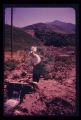
Party of people viewing large landslide mass. Slide plane (surface along which mass of earth moved) is evident in photo half way down the exposed wall, sloping towards the party.
Image
75
Pavement of Big Cottonwood Canyon Road, east of Salt Lake City, torn up by cloudburst flood in August 1969.
1969-08
Image
51
-
75
of
100
<
1
2
3
4
>