Home
Browse
Ask Us
Chat
Harmful Language Statement
Log in
Photo Archives
Advanced Search
About
Over 70,000 photos covering a variety of topics from Marriott Library Special Collections
Year
1872
1873
1874
1875
1876
1877
1878
1879
1880
1881
1882
1883
1884
1885
1886
1887
1888
1889
1890
1891
1892
1893
1894
1895
1896
1897
1898
1899
1900
1901
1902
1903
1904
1905
1906
1907
1908
1909
1910
1911
1912
1913
1914
1915
1916
1917
1918
1919
1920
1921
1922
1923
1924
1925
1926
1927
1928
1929
1930
1931
1932
1933
1934
1935
1936
1937
1938
1939
1940
1941
1942
1943
1944
1945
1946
1947
1948
1949
1950
1951
1952
1953
1954
1955
1956
1957
1958
1959
1960
1961
1962
1963
1964
1965
1966
1967
1968
1969
1970
1971
1972
1973
1974
1975
1976
1977
1978
1979
1980
1981
1982
1983
1984
1985
1986
1987
1988
1989
1990
1991
1992
1993
TO
1872
1873
1874
1875
1876
1877
1878
1879
1880
1881
1882
1883
1884
1885
1886
1887
1888
1889
1890
1891
1892
1893
1894
1895
1896
1897
1898
1899
1900
1901
1902
1903
1904
1905
1906
1907
1908
1909
1910
1911
1912
1913
1914
1915
1916
1917
1918
1919
1920
1921
1922
1923
1924
1925
1926
1927
1928
1929
1930
1931
1932
1933
1934
1935
1936
1937
1938
1939
1940
1941
1942
1943
1944
1945
1946
1947
1948
1949
1950
1951
1952
1953
1954
1955
1956
1957
1958
1959
1960
1961
1962
1963
1964
1965
1966
1967
1968
1969
1970
1971
1972
1973
1974
1975
1976
1977
1978
1979
1980
1981
1982
1983
1984
1985
1986
1987
1988
1989
1990
1991
1992
1993
Type
Image
3,451
Format
image/jpeg
3,451
Collection
Photo Archives
3,451
Filters:
Collection Name:
"Herbert E. Gregory"
Format:
"image/jpeg"
Type:
"Image"
501
-
525
of
3,451
<
16
17
18
19
20
21
22
23
24
25
>
Gallery view
Number of results to display per page
10
25
50
100
200
Sort by Relevance
Sort by Title A-Z
Sort by Title Z-A
Sort by Date Ascending
Sort by Date Descending
Sort by Last Modified Ascending
Sort by Last Modified Descending
Title
Date
Type
501
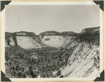
Castro Bluff, view looking westward from its base. Terrace developed in the Sevier(?) formation at the top of the Wasatch formation
1941
Image
502
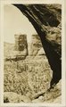
Cathedral Arch I. Arch Canyon
1920; 1921; 1922; 1923; 1924; 1925; 1926; 1927; 1928; 1929; 1930
Image
503
Cathedral Arch I. Arch Canyon
1920; 1921; 1922; 1923; 1924; 1925; 1926; 1927; 1928; 1929; 1930
Image
504
Cathedral Arch II, Arch Canyon, Coconino over Supai
1920; 1921; 1922; 1923; 1924; 1925; 1926; 1927; 1928; 1929; 1930
Image
505
Cathedral Arch II, Arch Canyon, Coconino over Supai
1920; 1921; 1922; 1923; 1924; 1925; 1926; 1927; 1928; 1929; 1930
Image
506
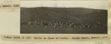
Cattle on floor of crater, Parker Ranch, Hawaii, 1926
1926
Image
507
Cave Canyon walls of Navajo sandstone, above them shale and Temple Cap member forms second cliff, capped in turn with Carmel limestone. Zion National Park
1937; 1938
Image
508
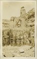
Cave in Navajo sandstone east slope Comb monocline in Butler Wash, 11 miles from mouth. San Juan County, UT, 1928
Image
509
Cave in Navajo sandstone east slope Comb monocline in Butler Wash, 11 miles from mouth. San Juan County, UT, 1928
1928
Image
510
Cave in Navajo sandstone east slope Comb monocline in Butler Wash, 11 miles from mouth. San Juan County, UT, 1928
1928
Image
511
Cave Lakes Canyon, 1936
1936
Image
512
Cedar mesa looking north from edge of Johns Canyon. Coconino(?) on Supai(?). San Juan County, UT, 1928
1928
Image
513
Cedar mesa looking north from edge of Johns Canyon. Coconino(?) on Supai(?). San Juan County, UT, 1928
1928
Image
514
Cedar mesa looking north from edge of Johns Canyon. Coconino(?) on Supai(?). San Juan County, UT, 1928
1928
Image
515
Cedar Mesa, Moencopie strata, 4± mi. northwest of Goodridge, Utah (Chas. Goodman photo)
1909
Image
516
Cedar Ridge. Cap of Shinarump conglomerate and upper Moenkopi extending south from Vermillion Cliffs onto Uinkaret Plateau west of Pipe Wash, Mohave County, AZ. 1939
1939
Image
517
Central point, Mt. Trumbull
1900
Image
518
Cha-ez Kla. (No. 4). Volcanic neck or dike, 2+ mi, south of Agathla Needle, Ariz., 1910 (Photo G147)
1910
Image
519
Changing a tire
1916
Image
520
Chief Harry Supela (naked) about to enter snake kiva at Walpi, morning of snake dance. Great altar is partly seen through the covered passage way
1915
Image
521
Chile formation, Petrified Forest member, and upper Chinle beds ( upper left). Branch of Road Canyon. Kane County, UT. 1943
1943
Image
522
Chimney Butte, volcanic neck, 25± mi. north of Winslow, AZ. 1911 (Photo G240)
1911
Image
523
Chimney Park, Dry Valley. Tributary of Paria Canyon. Erosion remnant of 'Sentinel' sandstone capped by Dakota. Kane County, UT. 1922
1922
Image
524
Chimney Park, Dry Valley. Tributary to Paria Canyon. Front of plateau. 'Sentinel' sandstone at base of followed upward by Dakota, Mancos and Mesa Verde. Kane County, UT. 1922
1922
Image
525
Chimney Rock on Tees-Nos-Pos trail
1913
Image
501
-
525
of
3,451
<
16
17
18
19
20
21
22
23
24
25
>