Home
Browse
Ask Us
Chat
Harmful Language Statement
Log in
Advanced Search
Year
1871
1872
1873
1874
1875
1876
1877
1878
1879
1880
1881
1882
1883
1884
1885
1886
1887
1888
1889
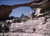
1890
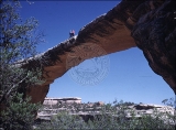
1891
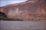
1892
1893
1894
1895
1896
1897
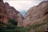
1898
1899
1900
1901
1902
1903
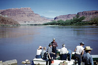
1904
1905
1906
1907
1908
1909
1910
1911
1912
1913
1914
1915
1916
1917
1918
1919
1920
1921
1922
1923
1924
1925
1926
1927
1928
1929
1930
1931
1932
1933
1934
1935
1936
1937
1938
1939
1940
1941
1942
1943
1944
1945
1946
1947
1948
1949
1950
1951
1952
1953
1954
1955
1956
1957
1958
1959
1960
1961
1962
1963
1964
1965
1966
1967
1968
1969
1970
1971
1972
1973
1974
1975
1976
1977
1978
1979
1980
1981
1982
1983
1984
1985
1986
1987
1988
1989
1990
1991
1992
1993
1994
1995
1996
1997
1998
1999
2000
2001
2002
2003
2004
2005
2006
2007
2008
2009
2010
2011
2012
2013
2014
2015
2016
2017
2018
2019
2020
2021
2022
2023
2024
TO
1871
1872
1873
1874
1875
1876
1877
1878
1879
1880
1881
1882
1883
1884
1885
1886
1887
1888
1889
1890
1891
1892
1893
1894
1895
1896
1897
1898
1899
1900
1901
1902
1903
1904
1905
1906
1907
1908
1909
1910
1911
1912
1913
1914
1915
1916
1917
1918
1919
1920
1921
1922
1923
1924
1925
1926
1927
1928
1929
1930
1931
1932
1933
1934
1935
1936
1937
1938
1939
1940
1941
1942
1943
1944
1945
1946
1947
1948
1949
1950
1951
1952
1953
1954
1955
1956
1957
1958
1959
1960
1961
1962
1963
1964
1965
1966
1967
1968
1969
1970
1971
1972
1973
1974
1975
1976
1977
1978
1979
1980
1981
1982
1983
1984
1985
1986
1987
1988
1989
1990
1991
1992
1993
1994
1995
1996
1997
1998
1999
2000
2001
2002
2003
2004
2005
2006
2007
2008
2009
2010
2011
2012
2013
2014
2015
2016
2017
2018
2019
2020
2021
2022
2023
2024
Type
Text
438
Sound
6
Image
5
Image/StillImage
2
Format
application/pdf
3,020
image/jpeg
122
application/xml
1
Collection
Aileen Clyde Oral History Project
2
Alan K Engen Papers
2
Allen H. Lundgren Papers
1
American West Center Research Projects
3
Athletics
7
College of Law Publications
36
College of Nursing
27
College of Pharmacy
3
Continuum
4
Cycling Utah
1
Electronic University Archive
29
Encoded Archival Description (EAD) Fi...
1
Everett L. Cooley Oral History Project
7
Historic and Prehistoric Publications
12
Illuminations
2
Institute for Clean and Secure Energy...
1
Intermountain Ski Instructors Associa...
11
Ivy Baker Priest Papers
1
Land Use - Transportation Scenario Pl...
1
League of Women Voters of Utah
1
Linford and Richards Family Collection
4
Manuscripts
3
Marriner S. Eccles Papers
8
Marriott Library Digital Stacks
2
Midvale Museum
1
Mormon Settlement in Arizona
2
NOVEL - Journal of Neuro-Ophthalmology
15
Network Magazine Records
29
Peoples of Utah Revisited
5
Photo Archives
1
Public Affairs of Health Sciences Center
11
Salt Lake Tribune Negative Collection
2
School of Medicine Yearbooks
1
Sustainability U
1
Theses & Dissertations
37
UMFA Docent Archive
7
UScholar Works
6
Undergrad Research Abstracts Journal
1
University of Utah Board of Regents M...
3
University of Utah Press Open Access ...
4
Utah Architects and Builders
4
Utah City Directories Collection
2,328
Utah Health Sciences Library Consortium
1
Utah Historic Building Records
147
Utah Medical Association Bulletin
15
Utah Nurse
19
Utah Pharmacy Digest
30
Utah River Running Photo Archives
120
Utah State Board Of Regents
47
Utonian Yearbooks
137
More
26
-
50
of
3,143
<
1
2
3
4
5
6
7
8
9
10
>
Gallery view
Number of results to display per page
10
25
50
100
200
Sort by Relevance
Sort by Title A-Z
Sort by Title Z-A
Sort by Date Ascending
Sort by Date Descending
Sort by Last Modified Ascending
Sort by Last Modified Descending
Title
Date
Type
Setname
26
"Climbing on board at Hite."
1951-05-11
uum_map_rr
27
"Frank and Barbara on top of Owachomo."
1951-05-10
uum_map_rr
28
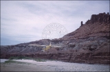
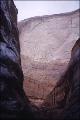
"Owachamo Bridge, 108 ft high, 200 ft span."
1951-05-10
uum_map_rr
29
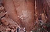
"Sheer wall on right." [Tapestry Wall]
1951-05-12
uum_map_rr
30
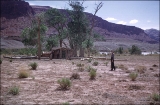
"Bert Loper's Cabin, Mile 150."
1951-05-11
uum_map_rr
31
"Pilot Jim Rigg taking off in 100 ft."
1951-05-11
uum_map_rr
32
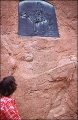
"Plaque to commemorate Pauite Nisjah Begay who first led white men to near Goshi."
1951-05-15
uum_map_rr
33
"Rainbow Bridge register #7301"
1951-05-15
uum_map_rr
34
"Hole in the Rock, mile 84.5."
1951-05-14
uum_map_rr
35
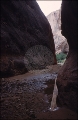
"Leaving Hidden Passage."
1951-05-14
uum_map_rr
36
"One of the larger variety of lizard."
1951-05-17
uum_map_rr
37
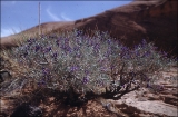
"Purple Sage Mile 118."
1951-05
uum_map_rr
38
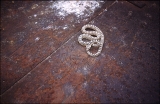
"Snake in dump car at Gerhart mine."
1951-05-12
uum_map_rr
39
"2 of 3 Henry Mountains to North from mile 119."
1951-05
uum_map_rr
40
"M. by tamarisk looking East from Kane Creek above crossing of the Fathers."
1951-05-16
uum_map_rr
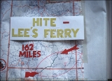
41
Hite at Lee's Ferry, 162 miles.
1951-05
uum_map_rr
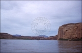
42
Map of the Colorado River.
1951
uum_map_rr
43
"Commemorative plaque erected Aug 13, 1939. Hole in the Rock."
1951-05-14
uum_map_rr
44
"Escalante on left mile 87.75. 7 A.M. May 14, 1951."
1951-05-14
uum_map_rr
45
"Escalante River entering Colorado River."
1951-05
uum_map_rr
46
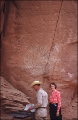
"Joe photographing bridge from south side."
1951-05-15
uum_map_rr
47
"Lunch at Annie's Canyon, mile 108."
1951-05
uum_map_rr
48
"Lunch time beneath Rainbow Bridge. 5-15-51"
1951-05-15
uum_map_rr
49
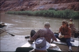
"Midmorning candy call exchange between Bill and Verona."
1951-05-14
uum_map_rr
50
"Mystery Canyon."
1951-05-14
uum_map_rr
26
-
50
of
3,143
<
1
2
3
4
5
6
7
8
9
10
>