Home
Browse
Ask Us
Chat
Harmful Language Statement
Log in
Advanced Search
Year
1671
1672
1673
1674
1675
1676
1677
1678
1679
1680
1681
1682
1683
1684
1685
1686
1687
1688
1689
1690
1691
1692
1693
1694
1695
1696
1697
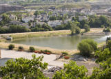
1698
1699
1700
1701
1702
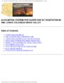
1703
1704
1705
1706
1707
1708
1709
1710
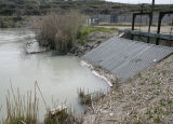
1711
1712
1713
1714
1715
1716
1717
1718
1719
1720
1721
1722
1723
1724
1725
1726
1727
1728
1729
1730
1731
1732
1733
1734
1735
1736
1737
1738
1739
1740
1741
1742
1743
1744
1745
1746
1747
1748
1749
1750
1751
1752
1753
1754
1755
1756
1757
1758
1759
1760
1761
1762
1763
1764
1765
1766
1767
1768
1769
1770
1771
1772
1773
1774
1775
1776
1777
1778
1779
1780
1781
1782
1783
1784
1785
1786
1787
1788
1789
1790
1791
1792
1793
1794
1795
1796
1797
1798
1799
1800
1801
1802
1803
1804
1805
1806
1807
1808
1809
1810
1811
1812
1813
1814
1815
1816
1817
1818
1819
1820
1821
1822
1823
1824
1825
1826
1827
1828
1829
1830
1831
1832
1833
1834
1835
1836
1837
1838
1839
1840
1841
1842
1843
1844
1845
1846
1847
1848
1849
1850
1851
1852
1853
1854
1855
1856
1857
1858
1859
1860
1861
1862
1863
1864
1865
1866
1867
1868
1869
1870
1871
1872
1873
1874
1875
1876
1877
1878
1879
1880
1881
1882
1883
1884
1885
1886
1887
1888
1889
1890
1891
1892
1893
1894
1895
1896
1897
1898
1899
1900
1901
1902
1903
1904
1905
1906
1907
1908
1909
1910
1911
1912
1913
1914
1915
1916
1917
1918
1919
1920
1921
1922
1923
1924
1925
1926
1927
1928
1929
1930
1931
1932
1933
1934
1935
1936
1937
1938
1939
1940
1941
1942
1943
1944
1945
1946
1947
1948
1949
1950
1951
1952
1953
1954
1955
1956
1957
1958
1959
1960
1961
1962
1963
1964
1965
1966
1967
1968
1969
1970
1971
1972
1973
1974
1975
1976
1977
1978
1979
1980
1981
1982
1983
1984
1985
1986
1987
1988
1989
1990
1991
1992
1993
1994
1995
1996
1997
1998
1999
2000
2001
2002
2003
2004
2005
2006
2007
2008
2009
2010
2011
2012
2013
2014
2015
2016
2017
2018
2019
2020
2021
2022
2023
2024
TO
1671
1672
1673
1674
1675
1676
1677
1678
1679
1680
1681
1682
1683
1684
1685
1686
1687
1688
1689
1690
1691
1692
1693
1694
1695
1696
1697
1698
1699
1700
1701
1702
1703
1704
1705
1706
1707
1708
1709
1710
1711
1712
1713
1714
1715
1716
1717
1718
1719
1720
1721
1722
1723
1724
1725
1726
1727
1728
1729
1730
1731
1732
1733
1734
1735
1736
1737
1738
1739
1740
1741
1742
1743
1744
1745
1746
1747
1748
1749
1750
1751
1752
1753
1754
1755
1756
1757
1758
1759
1760
1761
1762
1763
1764
1765
1766
1767
1768
1769
1770
1771
1772
1773
1774
1775
1776
1777
1778
1779
1780
1781
1782
1783
1784
1785
1786
1787
1788
1789
1790
1791
1792
1793
1794
1795
1796
1797
1798
1799
1800
1801
1802
1803
1804
1805
1806
1807
1808
1809
1810
1811
1812
1813
1814
1815
1816
1817
1818
1819
1820
1821
1822
1823
1824
1825
1826
1827
1828
1829
1830
1831
1832
1833
1834
1835
1836
1837
1838
1839
1840
1841
1842
1843
1844
1845
1846
1847
1848
1849
1850
1851
1852
1853
1854
1855
1856
1857
1858
1859
1860
1861
1862
1863
1864
1865
1866
1867
1868
1869
1870
1871
1872
1873
1874
1875
1876
1877
1878
1879
1880
1881
1882
1883
1884
1885
1886
1887
1888
1889
1890
1891
1892
1893
1894
1895
1896
1897
1898
1899
1900
1901
1902
1903
1904
1905
1906
1907
1908
1909
1910
1911
1912
1913
1914
1915
1916
1917
1918
1919
1920
1921
1922
1923
1924
1925
1926
1927
1928
1929
1930
1931
1932
1933
1934
1935
1936
1937
1938
1939
1940
1941
1942
1943
1944
1945
1946
1947
1948
1949
1950
1951
1952
1953
1954
1955
1956
1957
1958
1959
1960
1961
1962
1963
1964
1965
1966
1967
1968
1969
1970
1971
1972
1973
1974
1975
1976
1977
1978
1979
1980
1981
1982
1983
1984
1985
1986
1987
1988
1989
1990
1991
1992
1993
1994
1995
1996
1997
1998
1999
2000
2001
2002
2003
2004
2005
2006
2007
2008
2009
2010
2011
2012
2013
2014
2015
2016
2017
2018
2019
2020
2021
2022
2023
2024
Type
Text
510
Image
17
Sound
9
Image/MovingImage
1
Image/StillImage
1
Format
application/pdf
1,164
image/jpeg
21
application/xml
2
Collection
Alan K Engen Papers
2
Allen H. Lundgren Papers
1
American West Center Research Projects
6
Art MFA Thesis and Final Project Papers
1
Athletics
1
Aziz Suryal Atiya papers
1
Beckwith Photograph Collection
1
Civilian Conservation Corps Newslette...
8
Classified Photographs
1
College of Law Publications
39
College of Pharmacy
1
Colorado Riverbed Case
7
Cycling Utah
2
Department of City and Metropolitan P...
3
Earl Douglass Papers
1
Electronic University Archive
36
Elias Hicks Blackburn Papers, 1848-1908
1
Encoded Archival Description (EAD) Fi...
2
Everett L. Cooley Oral History Project
18
France Davis Utah Black Archive
1
Frederick William Reynolds Lectures
1
George A. Smith Papers
1
Glen Canyon
2
Great Salt Lake Oral History Collection
2
Hidden Water - Salt Lake County Water...
11
Hinckley Journal of Politics
1
Historic and Prehistoric Publications
100
Honors Theses Closed Archive
2
Honors Theses Open Access
6
Institute for Clean and Secure Energy...
1
Intermountain Acoustic Music
2
Intermountain Ski Instructors Associa...
4
Jacob Myers Sr. Papers, 1801-2009
4
John Wesley Powell Collection
11
Juanita Brooks Papers
19
Kem C. Gardner Policy Institute Colle...
1
Land Use - Transportation Scenario Pl...
15
League of Women Voters of Utah
3
MFA Final Projects
1
Manuscripts
2
Marriner S. Eccles Papers
18
Mormon Settlement in Arizona
28
NOVEL - Irene E. Loewenfeld Pupil Col...
2
Neighborhood Partners
1
Network Magazine Records
3
Photo Archives
8
Public Affairs of Health Sciences Center
2
Rare Books Collection
109
Reverend France A. Davis Papers
1
Susan Barbara Tallmon Sargent
7
Sustainability U
1
Theses & Dissertations
126
UAIDA Main Collection
21
UScholar Works
24
University of Utah Press Open Access ...
12
Utah Architects and Builders
4
Utah Arts Council - Writing Competiti...
2
Utah Historic Building Records
201
Utah Historic Building Reports
2
Utah Historical Society Oral History ...
9
Utah Medical Association Bulletin
3
Utah National Register Nomination Forms
6
Utah Nurse
1
Utah Pharmacy Digest
9
Utah State Board Of Regents
1
Water Wise Utah
7
Western Waters AZ. vs CA.
15
Western Waters Books
13
Western Waters Documents
161
Western Waters Electronic Resources
5
Western Waters NEH
52
Western Waters Treaties and Compacts
5
William Harroun Behle Papers
5
Works Progress Administration Biograp...
1
More
26
-
50
of
1,187
<
1
2
3
4
5
6
7
8
9
10
>
Gallery view
Number of results to display per page
10
25
50
100
200
Sort by Relevance
Sort by Title A-Z
Sort by Title Z-A
Sort by Date Ascending
Sort by Date Descending
Sort by Last Modified Ascending
Sort by Last Modified Descending
Title
Date
Type
Setname
26
Reel 1 Volume 0.1-0.2 - Page 52
usa_crc
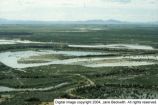
27
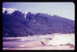
Flooding from snow runoff, mouth of Weber Canyon. Weber River has overtopped its normal channel banks and covers its flood plain. Periodically, structures situated on this flood plain become inundated. Note: ancient Lake Bonneville terraces may be seen on the mountain front.
Image
uum_map
28
Page 34
dha_uhbr
29
UUM_LowerColoMain_page_135
wwdl_documents
30
UUM_WPolicy_page_144
wwdl_documents
31
Method to identify wells that yield water that will be replaced by water from the Colorado River downstream from Laguna Dam in Arizona and California
2000
Text
wwdl_er
32
UUM_SumDigest_page_410
wwdl_documents
33
UUM_LowerColoMain_page_119
wwdl_documents
34
Utah State Water Plan, Jordan River Basin - Page 141
wwdl_documents
35
Joint Dam
2011-05-02
Image
uu_hw_slcwd
36
Reel 3 Volume 1 - Page 125
usa_crc
37
UUM_SumDigest_page_308
wwdl_documents
38
Page 23
wwdl_neh
39
Abstract Testimony, V 1, p. 0025
usa_crc
40
Accounting system for water use by vegetation in the lower Colorado River Valley
1992
Text
wwdl_er
41
Cache Valley: House in flood plain above Riverdale Road (negative)
2001-11
uum_map
42
Cache Valley: House in flood plain above Riverdale Road (negative)
2001-11
uum_map
43
Great Salt Lake, Draft Comprehensive Management Plan - Page 311
wwdl_documents
44
Great Salt Lake, Draft Comprehensive Management Plan - Page 34
wwdl_documents
45
page 485
wwdl_documents
46
UUM_WPolicy_page_146
wwdl_documents
47
UUM_LowerColoMain_page_148
wwdl_documents
48
Flood basin
2008-06-27
Image
uu_hw_slcwd
49
Sevier River flood of 1983, vicinity of Delta, Utah [229]
1983-06
Image
dc_bpc
50
page 217
wwdl_documents
26
-
50
of
1,187
<
1
2
3
4
5
6
7
8
9
10
>