| Title | Date | Type | Setname | ||
|---|---|---|---|---|---|
| 26 |
 |
Ashley Creek Flooding | Image | ucl_vep | |
| 27 |
 |
Dry Creek outlet at Jordan River | 2009-05-06 | Image | uu_hw_slcwd |
| 28 |
 |
Creek and fairway | 2009-05-06 | Image | uu_hw_slcwd |
| 29 |
 |
Petroglyph or Rock Art | Image | ucl_tp | |
| 30 |
 |
Creek near club house | 2009-05-06 | Image | uu_hw_slcwd |
| 31 |
 |
Dry Fork Flume | 1960; 1961; 1962; 1963; 1964; 1965; 1966; 1967; 1968; 1969; 1970 | Image/StillImage | ucl_rhc |
| 32 |
 |
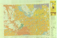
Geologic Map of Uintah County, Utah - North Half - 1950s | 1950; 1951; 1952; 1953; 1954; 1955; 1956; 1957; 1958; 1959 | Image/StillImage | ucl_maps |
| 33 |
 |
Page 15 | wwdl_neh | ||
| 34 |
 |
Dry Fork Flume | Image | ucl_tp | |
| 35 |
 |
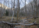
Land Sinks in Dry Fork | 1968-08-01 | Image/StillImage | ucl_vep |
| 36 |
 |
Page 149 | uum_manu | ||
| 37 |
 |
Water resources data: Utah: water year 2002 | 2003 | Text | uu_wwu |
| 38 |
 |
Rivulet in Dimple Dell | 2010-06-09 | Image | uu_hw_slcwd |
| 39 |
 |
Sheep P.9 | Image | dha_cp | |
| 40 |
 |
Dinosaurland One-Day Self-Guided Tour #11 Rock Creek and Upper Stillwater Dam | Image/StillImage | ucl_maps | |
| 41 |
 |
Dinosaurland One-Day Self-Guided Tour #10 North Fork of the Duchesne River | Image/StillImage | ucl_maps | |
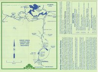
| 42 |
 |
Geological Map of Uintah County, Utah - North Half - 1950s | 1950; 1951; 1952; 1953; 1954; 1955; 1956; 1957; 1958; 1959 | Image/StillImage | ucl_maps |
| 43 |
 |
Page 123 | dha_uhbr | ||
| 44 |
 |
Ashley Survey Positive Sanborn 1880 | 1880 | Image/StillImage | ucl_maps |
| 45 |
 |
Page 11 | ir_etd | ||
| 46 |
 |
Vernal, Utah 1993 | 1993 | Image/StillImage | ucl_maps |
| 47 |
 |
Main Fork dry bed | 2008-11-25 | Image | uu_hw_slcwd |
| 48 |
 |
Page 23 | dha_wpabs | ||
| 49 |
 |
Dutch John, Utah-Colorado-Wyoming 1982 | 1981; 1982 | Image/StillImage | ucl_maps |
| 50 |
 |
Dinosaurland One-Day Self-Guided Tour #8 Sheep Creek Canyon and Spirit Lake | Image/StillImage | ucl_maps |