Over 70,000 photos covering a variety of topics from Marriott Library Special Collections
TO
Filters: Collection: "uum_map"
| Title | Collection Number And Name | Photo Number | ||
|---|---|---|---|---|
| 26 |
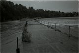 |
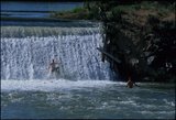
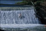
Last Chance diversion, Idaho (negative) [10] | P2162 Bear River Portfolio by Craig Denton | P2162n02_13_010 |
| 27 |
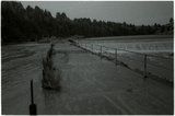 |
Last Chance diversion, Idaho (negative) [11] | P2162 Bear River Portfolio by Craig Denton | P2162n02_13_011 |
| 28 |
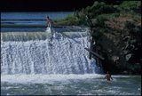 |
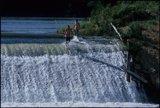
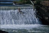
Last Chance diversion, Idaho [01] | P2162 Bear River Portfolio by Craig Denton | P2162n06_14_001 |
| 29 |
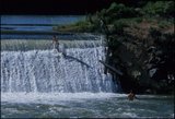 |
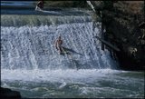
Last Chance diversion, Idaho [02] | P2162 Bear River Portfolio by Craig Denton | P2162n06_14_002 |
| 30 |
 |
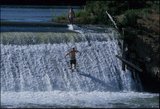
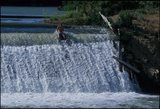
Last Chance diversion, Idaho [03] | P2162 Bear River Portfolio by Craig Denton | P2162n06_14_003 |
| 31 |
 |
Last Chance diversion, Idaho [04] | P2162 Bear River Portfolio by Craig Denton | P2162n06_14_004 |
| 32 |
 |
Last Chance diversion, Idaho [05] | P2162 Bear River Portfolio by Craig Denton | P2162n06_14_005 |
| 33 |
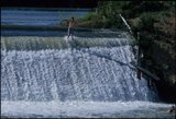 |
Last Chance diversion, Idaho [06] | P2162 Bear River Portfolio by Craig Denton | P2162n06_14_006 |
| 34 |
 |
Last Chance diversion, Idaho [07] | P2162 Bear River Portfolio by Craig Denton | P2162n06_14_007 |
| 35 |
 |
Last Chance diversion, Idaho [08] | P2162 Bear River Portfolio by Craig Denton | P2162n06_14_008 |
| 36 |
 |
Last Chance diversion, Idaho [09] | P2162 Bear River Portfolio by Craig Denton | P2162n06_14_009 |
| 37 |
 |
Last Chance diversion, Idaho [10] | P2162 Bear River Portfolio by Craig Denton | P2162n06_14_010 |
| 38 |
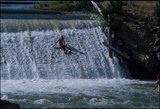 |
Last Chance diversion, Idaho [11] | P2162 Bear River Portfolio by Craig Denton | P2162n06_14_011 |
| 39 |
 |
Last Chance diversion, Idaho [13] | P2162 Bear River Portfolio by Craig Denton | P2162n06_14_013 |
| 40 |
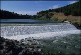 |
Last Chance diversion, Idaho [15] | P2162 Bear River Portfolio by Craig Denton | P2162n06_14_015 |
| 41 |
 |
Flooding in Willard, Utah : "beaver dam" built by man to divert the stream (Willard Creek) into the barrier basin [and] Temporary spillway just above highway crossing | P0208 Utah Flood Survey photograph collection | P0208n01_01_019-020 |
| 42 |
 |
Woodruff spillway : Woodruff equalizing reservoir, showing first construction camp, 1926, and beginning of the new dam [and] Woodruff spillway at the height of 24 ft., which was the first level reached | P0208 Utah Flood Survey photograph collection | P0208n01_01_082-083 |
| 43 |
 |
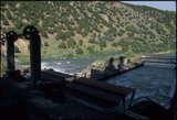
Black Canyon and Soda Point, Idaho [08] | P2162 Bear River Portfolio by Craig Denton | P2162n05_01_008 |
| 44 |
 |
Black Canyon and Soda Point, Idaho [09] | P2162 Bear River Portfolio by Craig Denton | P2162n05_01_009 |
| 45 |
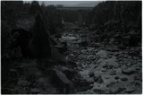 |
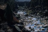
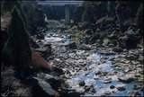
Spring fed river in Black Canyon after water removed via Last Chance (negative) [1] | P2162 Bear River Portfolio by Craig Denton | P2162n01_18_034 |
| 46 |
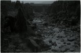 |
Spring fed river in Black Canyon after water removed via Last Chance (negative) [2] | P2162 Bear River Portfolio by Craig Denton | P2162n01_18_035 |
| 47 |
 |
Spring fed river in Black Canyon after water removed via Last Chance (negative) [3] | P2162 Bear River Portfolio by Craig Denton | P2162n01_18_036 |
| 48 |
 |
Flooding in Willard, Utah : Emergency highway crossing of flood control channel, with teams at work endeavoring to keep the channel open [date] [and] the same 5 days later | P0208 Utah Flood Survey photograph collection | P0208n01_01_021-022 |
| 49 |
 |
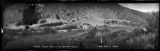
Fiftymile Gulch, Utah [01] | P0796 Bill Wolverton Photograph Collection | P0796n01_13_01 |
| 50 |
 |
Bear Lake development [06]: Georgetown Canyon | P0206 Rocky Mountain Power Company Photograph Collection | P0206add2n01_18_006 neg adj |