TO
| Author | Title | Subject | Date | Publication Type | ||
|---|---|---|---|---|---|---|
| 26 |
 |
Eriksson, Yves | Geology of the upper Ogden Canyon, Weber County, Utah | Geology -- Utah -- Weber County | 1960-06 | thesis |
| 27 |
 |
Morris, Elliot Cobia | Geology of the Big Piney area, Summit County, Utah | Geology -- Utah -- Summit County | 1953-06 | thesis |
| 28 |
 |
Condie, Kent C. | Petrogeneis of the Mineral Range Pluton, Southwestern Utah | Petrology -- Utah -- Beaver County; Millard County; Geology -- Utah -- Beaver County; Millard County; Mineral Range (Utah) | 1960-06 | thesis |
| 29 |
 |
Doelling, Hellmut H. | Geology of the Northern Lakeside Mountains and the Grassy Mountains and vicinity, Tooele and Box Elder Counties, Utah | Geology -- Utah -- Tooele County; Geology -- Utah -- Box Elder County; Geology -- Utah -- Grassy Mountains -- Maps; Geology -- Utah -- Lakeside Mountains -- Maps | 1964-06 | thesis |
| 30 |
 |
Johnson, Eric Henry | Plate 2 Topography, resistivity, and chargeability cross-sections along dipole-dipole line 1 on Fumarole Butte | Basalt -- Utah; Geothermal resources -- Utah | 1975-08 | thesis |
| 31 |
 |
Johnson, Eric Henry | Resistivity and induced polarization survey of a basalt flow in a geothermal environment, Western Utah | Basalt -- Utah; Geothermal resources -- Utah | 1975-08 | thesis |
| 32 |
 |
Johnson, Eric Henry | Plate1 Map of Fumarole Butte showing topography, geology, and locations of dipole-dipole profiles and Schlumberger soundings | Basalt -- Utah; Geothermal resources -- Utah | 1975-08 | thesis |
| 33 |
 |
Johnson, Eric Henry | Plate 3 Topography, resistivity, and chargeability cross-sections along dipole-dipole line 2 on Fumarole Butte | Basalt -- Utah; Geothermal resources -- Utah | 1975-08 | thesis |
| 34 |
 |
Temple, Dennis Charles | Mount Ogden granite (Thesis and maps) | Granite; Utah; Mount Ogden; Geology; Stratigraphic; Precambrian ; Rocks; Crystalline; Metamorphic | 1969-06 | thesis |
| 35 |
 |
Boschetto, Harold Bradley | Plate 1: Geologic map of the Lothidok Range, Kenya | Geology; Kenya; Lothidok Range | 1988-08 | map |
| 36 |
 |
Dolan, Michael | Sandy fitness environment, Sandy City, Utah | Recreation centers; Designs; Plans | 2007 | thesis |
| 37 |
 |
Blue, Donald McCoy | Geology and ore deposits of the lucin mining district, Box Elder County, Utah, and Elko County, Nevada-Maps | 1960-08 | thesis | |
| 38 |
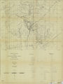 |
Baker, Walker Holcombe | Geologic setting and origin of the Grouse Creek pluton, Box Elder County, Utah-Maps | Geology--Utah | 1959-06 | thesis |
| 39 |
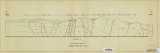 |
Baker, Walker Holcombe | Plate 2: Cross-section A-A' | 1959-06 | thesis | |
| 40 |
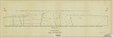 |
Baker, Walker Holcombe | Plate 3: Cross-section B-B' | 1959-06 | thesis | |
| 41 |
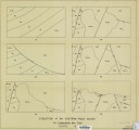 |
Baker, Walker Holcombe | Plate 4: Evolution of the eastern fault block | 1959-06 | thesis | |
| 42 |
 |
Harrill, James Reece | Geology of the Davis Knolls and northern Big Davis Mountain area, Tooele County, Utah | Geology -- Utah -- Tooele County; Thesis and dissertation georeferencing project | 1962-08 | thesis |
| 43 |
 |
Root, Robert L. | Geology of the Smith and Morehouse-Hayden Fork area, Utah | Geology; Utah; Summit County; Thesis and dissertation georeferencing project | 1952 | thesis |
| 44 |
 |
Thomson, Kenneth Clair | Mineral deposits of the Deep Creek Mountains, Tooele and Juab Counties, Utah (Thesis and maps) | Mines and mineral resources -- Utah -- Deep Creek Mountains | 1970-08 | thesis |
| 45 |
 |
Smith, Hugh Preston | The Thaynes formation of the Moenkopi group, North-Central Utah (Thesis and maps) | Geology; Utah; Thaynes Formation; Moenkopi group | 1969-06 | thesis |
| 46 |
 |
Parr, Clayton Joseph | A study of primary sedimentary structures around the Moab anticline, Grand County, Utah (Thesis and maps) | Geology; Utah; Grand County | 1965-08 | thesis |
| 47 |
 |
Stouffer, Stephen Gerald | Landslides in the Coal Hill area, Kane County, Utah (Thesis and maps) | Landslides -- Utah -- Kane County; Geology -- Utah -- Kane County | 1964-06 | thesis |
| 48 |
 |
Moussa, Mounir Tawfik | Geology of the Soldier Summit quadrangle, Utah (Thesis and maps) | Geology; Utah; Utah County; Carbon County; Wasatch County | 1965-06 | thesis |
| 49 |
 |
Chapusa, Frank W. P. | Geology and structure of Stansbury Island (Thesis and maps) | Geology; Utah; Stansbury Island | 1969-06 | thesis |
| 50 |
 |
Staub, Ann Marie | Geology of the Picture Rock Hills quadrangle, Southwestern Keg Mountains, Juab County, Utah (Thesis and maps) | Geology; Utah; Juab County | 1975 | thesis |