|
|
Author | Title | Subject | Date | Publication Type |
| 26 |
 |
Stifel, Peter Beekman | Geology of the Terrace and Hogup Mountains, Box Elder County, Utah | Geology -- Utah -- Box Elder County | 1964-06 | thesis |
| 27 |
 |
Stifel, Peter Beekman | Geology of the Terrace and Hogup Mountains, Box Elder County, Utah (Maps) | Geology -- Utah -- Box Elder County | 1964-06 | map |
| 28 |
 |
Eriksson, Yves | Geology of the upper Ogden Canyon, Weber County, Utah | Geology -- Utah -- Weber County | 1960-06 | thesis |
| 29 |
 |
Gardner, Weston Clive | Geology of the West Tintic mining district and vicinity, Juab County, Utah | Geology -- Utah -- Juab County -- Tintic Mining District; Thesis and dissertation georeferencing project | 1954-06 | thesis |
| 30 |
 |
Stouffer, Stephen Gerald | Landslides in the Coal Hill area, Kane County, Utah (Thesis and maps) | Landslides -- Utah -- Kane County; Geology -- Utah -- Kane County | 1964-06 | thesis |
| 31 |
 |
Thomson, Kenneth Clair | Mineral deposits of the Deep Creek Mountains, Tooele and Juab Counties, Utah (Thesis and maps) | Mines and mineral resources -- Utah -- Deep Creek Mountains | 1970-08 | thesis |
| 32 |
 |
Temple, Dennis Charles | Mount Ogden granite (Thesis and maps) | Granite; Utah; Mount Ogden; Geology; Stratigraphic; Precambrian ; Rocks; Crystalline; Metamorphic | 1969-06 | thesis |
| 33 |
 |
Dalness, William Michael | Parunuweap formation in the vicinity of Zion National Park, Utah-Maps | | 1969-06 | thesis |
| 34 |
 |
Condie, Kent C. | Petrogeneis of the Mineral Range Pluton, Southwestern Utah | Petrology -- Utah -- Beaver County; Millard County; Geology -- Utah -- Beaver County; Millard County; Mineral Range (Utah) | 1960-06 | thesis |
| 35 |
 |
Neff, Thomas Rodney | Petrology and structure of the Little Willow Series, Wasatch Mountains, Utah-Maps | Petrology -- Utah -- Wasatch Mountains | 1962-11 | thesis |
| 36 |
 |
Vlam, Heber Adolf Arien | Petrology of Lake Bonneville Gravels Salt Lake County, Utah | Petrology; Utah; Salt Lake County; Bonneville; Thesis and dissertation georeferencing project | 1963-05 | thesis |
| 37 |
 |
Rodriguez, Enrique Levy | Plate 1: Geologic map and vertical cross section of the Sulphurdale sulphur deposits, Beaver and Millard Counties, Utah | | 1960-08 | thesis |
| 38 |
 |
Neff, Thomas Rodney | Plate 1: Geologic map of the Little Willow Series, Wasatch Mountains, Utah | | 1962-11 | thesis |
| 39 |
 |
Boschetto, Harold Bradley | Plate 1: Geologic map of the Lothidok Range, Kenya | Geology; Kenya; Lothidok Range | 1988-08 | map |
| 40 |
 |
Blakey, Ronald Clyde | Plate 1: Geologic map of the Paria NW quadrangle, Kane County, Utah | | 1970-08 | thesis |
| 41 |
 |
Sadeghi, Ali Reza | Plate 1: Geologic map of the Willard Peak area, North-Central Wasatch Mountains, Utah | | 1972-12 | thesis |
| 42 |
 |
Schaeffer, Frederick Ernst Jr. | Plate 1B: Geologic map of the Central and Southern Silver Island Mountains, Box Elder and Tooele Counties, Utah, and Elko County, Nevada | | 1961-06 | thesis |
| 43 |
 |
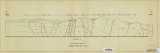
Schaeffer, Frederick Ernst Jr. | Plate 1C: Geologic cross sections of the Central and Southern Silver Island Mountains, Box Elder and Tooele Counties, Utah and Elko County, Nevada | | 1961-06 | thesis |
| 44 |
 |
Johnson, Eric Henry | Plate 2 Topography, resistivity, and chargeability cross-sections along dipole-dipole line 1 on Fumarole Butte | Basalt -- Utah; Geothermal resources -- Utah | 1975-08 | thesis |
| 45 |
 |
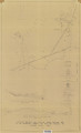
Baker, Walker Holcombe | Plate 2: Cross-section A-A' | | 1959-06 | thesis |
| 46 |
 |
Rodriguez, Enrique Levy | Plate 2: Detailed geologic and vertical cross sections map of the Excelsior Orebody and New York Prospect Pit, Millard County, Utah | | 1960-08 | thesis |
| 47 |
 |
Neff, Thomas Rodney | Plate 2: Sections along line A-A' and B-B' | | 1962-11 | thesis |
| 48 |
 |
Blakey, Ronald Clyde | Plate 2: Structural sections | | 1970-08 | thesis |
| 49 |
 |
Sadeghi, Ali Reza | Plate 2: Structure sections for geologic map of the Willard Peak area | | 1972-12 | thesis |
| 50 |
 |
Johnson, Eric Henry | Plate 3 Topography, resistivity, and chargeability cross-sections along dipole-dipole line 2 on Fumarole Butte | Basalt -- Utah; Geothermal resources -- Utah | 1975-08 | thesis |