Over 70,000 photos covering a variety of topics from Marriott Library Special Collections
TO
Filters: Collection Name: "Herbert E. Gregory" Type: "Image" Collection: "uum_map" Setname: !(ir* OR ehsl*)
| Title | Collection Number And Name | Photo Number | ||
|---|---|---|---|---|
| 26 |
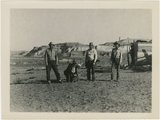 |
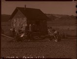
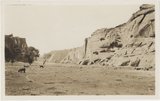
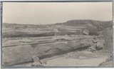
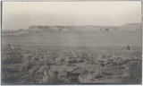
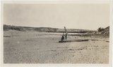
Paria Valley camp, 1943 | P0013 Herbert E. Gregory Photograph Collection | P0013n16_11_11 |
| 27 |
 |
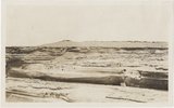
Paria Valley camp, 1943 | P0013 Herbert E. Gregory Photograph Collection | P0013n16_11_09 |
| 28 |
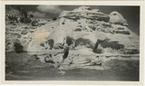 |
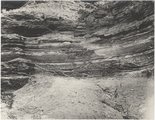
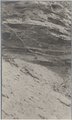
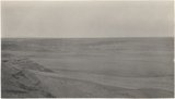
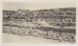
Shinarump outcrop near Paria, 1943 | P0013 Herbert E. Gregory Photograph Collection | P0013n16_11_07 |
| 29 |
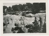 |
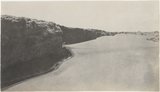
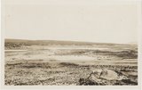
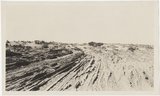
Starlight Canyon 1943 | P0013 Herbert E. Gregory Photograph Collection | P0013n16_11_03 |
| 30 |
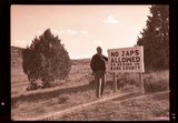 |
"No Japs allowed" sign, 1943 | P0013 Herbert E. Gregory Photograph Collection | P0013n15_11_11_neg |
| 31 |
 |
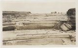
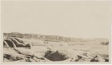
Paria Valley camp, 1943 | P0013 Herbert E. Gregory Photograph Collection | P0013n15_11_04_neg |
| 32 |
 |
Gypsum seams near Holbrook E.C.Case, photo. (Moencopie) | P0013 Herbert E. Gregory Photograph Collection | P0013n06_068_0963 |
| 33 |
 |
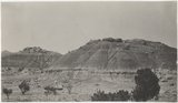
Baigaiche Mt. from "Beast" dike (Photo G388) | P0013 Herbert E. Gregory Photograph Collection | P0013n06_057_0941 |
| 34 |
 |
Canyon de Chelly. Cross-bedding (III-9 just like this) (Photo G374) | P0013 Herbert E. Gregory Photograph Collection | P0013n06_049_0925 |
| 35 |
 |
Canyon de Chelly. Shinarump capping Permian (Photo G373) | P0013 Herbert E. Gregory Photograph Collection | P0013n06_048_0924 |
| 36 |
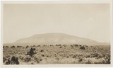 |
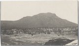
Distant (10 mi.) view of Navaho Mt., southeast (Photo G368) | P0013 Herbert E. Gregory Photograph Collection | P0013n06_045_0917 |
| 37 |
 |
Dunes filling Reservoir Canyon, Tuba (IV-8 in film book is also like this) (Photo G441) | P0013 Herbert E. Gregory Photograph Collection | P0013n06_093_1014 |
| 38 |
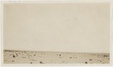 |
Flat between Little Colorado and Dolores cliff, Tolchaco. "Lake" shown is mirage (Photo G411) | P0013 Herbert E. Gregory Photograph Collection | P0013n06_075_0976 |
| 39 |
 |
Grand Falls, Little Colorado (Photo N-M175) | P0013 Herbert E. Gregory Photograph Collection | P0013n06_079_0986 |
| 40 |
 |
Grand Falls, panorama (Photos G415) | P0013 Herbert E. Gregory Photograph Collection | P0013n06_078a_0982 |
| 41 |
 |
Grand Falls, panorama (Photos G416) | P0013 Herbert E. Gregory Photograph Collection | P0013n06_078a_0983 |
| 42 |
 |
Gypsum in Permian. 2± mi. east of Holbrook (Photo G402) | P0013 Herbert E. Gregory Photograph Collection | P0013n06_067_0961 |
| 43 |
 |
Panorama, Red Wall and Baigaiche, looking across Red Lake (Photo G-378-380) | P0013 Herbert E. Gregory Photograph Collection | P0013n06_052_0931 |
| 44 |
 |
Peneplain; looking southeast from cliffs 5± mi. N 80 deg E, Black Falls (Photo N-M176 and G423) | P0013 Herbert E. Gregory Photograph Collection | P0013n06_081_0990 |
| 45 |
 |
View from "Beast" dike north across Red Lake (Photo G391) | P0013 Herbert E. Gregory Photograph Collection | P0013n06_060_0946 |
| 46 |
 |
View looking northeast up Black Creek from "Beast" dike (Photo G392) | P0013 Herbert E. Gregory Photograph Collection | P0013n06_060_0947 |
| 47 |
 |
Waterhole in desert 1± mi. below Sunrise Spgs. (Photo G395) | P0013 Herbert E. Gregory Photograph Collection | P0013n06_062_0950 |
| 48 |
 |
Wind carving Kaibab 2 mi. above Tolchaco (Photo G414) | P0013 Herbert E. Gregory Photograph Collection | P0013n06_077_0980 |
| 49 |
 |
Wind erosion, La Plata, Tuba (Photo G435) | P0013 Herbert E. Gregory Photograph Collection | P0013n06_088_1005 |
| 50 |
 |
Dolores Badlands 1 1/2 mile west of Nashlini. (I-5 & I-7 in film book just like this) (Photo N-M135) | P0013 Herbert E. Gregory Photograph Collection | P0013n06_003_0827 |