|
|
Title | Collection Number And Name | Photo Number |
| 26 |
 |
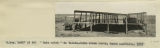
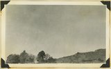
"North Forest", Carrizo Creek Wash (Photo G447) | P0013 Herbert E. Gregory Photograph Collection | P0013n06_098_1023 |
| 27 |
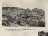 |
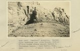
"Painted Desert Bads", 1 mi. below Farm, Tuba (Photo G432) | P0013 Herbert E. Gregory Photograph Collection | P0013n06_087_1002 |
| 28 |
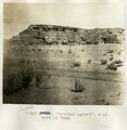 |
"Painted Desert", 2 mi. west of Tuba | P0013 Herbert E. Gregory Photograph Collection | P0013n07_029_1075 |
| 29 |
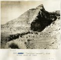 |
"Painted Desert", four miles west of Tuba | P0013 Herbert E. Gregory Photograph Collection | P0013n07_028_1074 |
| 30 |
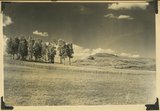 |
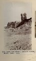
"Pryor Knoll, eroded basaltic cone and lava flows over Cretaceous rocks. View looking northwest. Western edge of Kolob Terrace. Just back of the yellow pines are the cliffs at the head of the westward flowing Shurtz Creek. Iron County, UT, 1942 | P0013 Herbert E. Gregory Photograph Collection | P0013n11_190_2831 |
| 31 |
 |
"Rain catch" on Yalata-Oldea stock route, South Australia, 1916 | P0013 Herbert E. Gregory Photograph Collection | P0013n13_112_9-3201 |
| 32 |
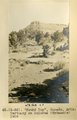 |
"Round Top," Ganado, Ariz. Tertiary on Dolores (Triassic), 1909 (photo G-36) | P0013 Herbert E. Gregory Photograph Collection | P0013n02_025_241 |
| 33 |
 |
"Sand waves" just breaking and flattening near Honoker Trail, San Juan canyon, 1921. | P0013 Herbert E. Gregory Photograph Collection | P0013n10_243_2515 |
| 34 |
 |
"Sentinel formation." Contact upper sandstone Section A with banded portion beneath, Section B. Cottonwood Canyon. Kane County, UT. 1922 | P0013 Herbert E. Gregory Photograph Collection | P0013n08_130_1562 |
| 35 |
 |
"Sentinel formation." Section B banded strata below heavy sandstone. Kaiparowitz region. Kane County, UT. 1922 | P0013 Herbert E. Gregory Photograph Collection | P0013n08_129_1560 |
| 36 |
 |
"Sentinel formation." Section B banded strata below heavy sandstone. Kaiparowitz region. Kane County, UT. 1922 | P0013 Herbert E. Gregory Photograph Collection | P0013n08_129_1561 |
| 37 |
 |
"Sigh," the pack mule, 1910 (Photo N-M103) | P0013 Herbert E. Gregory Photograph Collection | P0013n04_70_0641 |
| 38 |
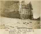 |
"The Church" (McElmo strata?), 4± mi southeast of Hlohala, Ariz., 1909 (photo G-107) | P0013 Herbert E. Gregory Photograph Collection | P0013n02_080_343 |
| 39 |
 |
"The Twins," LaPlata strata, Bluff, Utah, 1910 (Photo G134) | P0013 Herbert E. Gregory Photograph Collection | P0013n04_09_0527 |
| 40 |
 |
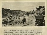
"The Washboard," head of North Canyon, looking west. Erosion caused by sheep grazing. Abajo Mountains. Utah, San Juan, 1915. | P0013 Herbert E. Gregory Photograph Collection | P0013n10_039_2155 |
| 41 |
 |
"The Window" (La Plata sandstone), between "Haystacks" and Ft. Defiance, Ariz. (Schwemberger photo), 1906 | P0013 Herbert E. Gregory Photograph Collection | P0013n02_011_214 |
| 42 |
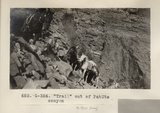 |
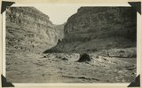
"Trail" out of PahUte canyon (Photo G354) | P0013 Herbert E. Gregory Photograph Collection | P0013n06_038_0900 |
| 43 |
 |
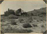
"Windsor Castle," Pipe Springs, 1936. | P0013 Herbert E. Gregory Photograph Collection | P0013n10_155_2354 |
| 44 |
 |
'"Sentinel formation." Contact upper sandstone just below Dakota, Section A, with banded strata beneath, Section B. Cottonwood Canyon. Kane County, UT. 1922 | P0013 Herbert E. Gregory Photograph Collection | P0013n08_130_1563 |
| 45 |
 |
'Elephant feet'. Wingate sandstone, Kayenta above. Three Lakes Canyon, Kane County, UT, 1939 | P0013 Herbert E. Gregory Photograph Collection | P0013n11_063_2631 |
| 46 |
 |
'Marine Jurassic' beds, Paunuweap, 4 miles below Mt. Carmel., at point where we measured section. UT | P0013 Herbert E. Gregory Photograph Collection | P0013n08_162_1641 |
| 47 |
 |
'The Granary': one of many natural cavities in Wingate sandstone utilized for storage, Johnson Canyon, Kane County, UT, 1939 | P0013 Herbert E. Gregory Photograph Collection | P0013n11_078_2658 |
| 48 |
 |
'White Throne' remnant of Navajo sandstone in branch of Paria River. Kane County, UT, 1940 | P0013 Herbert E. Gregory Photograph Collection | P0013n11_108_2699 |
| 49 |
 |
'Winsor Castle', old fort at Pipe Springs, looking south over Unikaret Plateau, Kanab Canyon upper right | P0013 Herbert E. Gregory Photograph Collection | P0013n11_101_2690 |
| 50 |
 |
'Winsor Castle,' old stone fort at Pipe Springs, Mohave County, AZ. Sevier fault passes between Navajo sandstone." (upper right) and lower Moenkopi (foreground). 1939 | P0013 Herbert E. Gregory Photograph Collection | P0013n11_090_2672 |