Home
Browse
Ask Us
Chat
Harmful Language Statement
Log in
Photo Archives
Advanced Search
About
Over 70,000 photos covering a variety of topics from Marriott Library Special Collections
Year
1930
1931
1932
1933
1934
1935
1936
1937
1938
1939
1940
1941
1942
1943
1944
1945
1946
1947
1948
1949
1950
1951
1952
1953
1954
1955
1956
1957
1958
1959
1960
1961
1962
1963
1964
1965
1966
1967
1968
1969
1970
TO
1930
1931
1932
1933
1934
1935
1936
1937
1938
1939
1940
1941
1942
1943
1944
1945
1946
1947
1948
1949
1950
1951
1952
1953
1954
1955
1956
1957
1958
1959
1960
1961
1962
1963
1964
1965
1966
1967
1968
1969
1970
Type
Image
100
Format
image/jpeg
100
Collection
Photo Archives
100
Filters:
Collection Name:
"Environmental Geology in Utah"
Type:
"Image"
26
-
50
of
100
<
1
2
3
4
>
Gallery view
Number of results to display per page
10
25
50
100
200
Sort by Relevance
Sort by Title A-Z
Sort by Title Z-A
Sort by Date Ascending
Sort by Date Descending
Sort by Last Modified Ascending
Sort by Last Modified Descending
Title
Date
Type
26
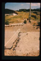
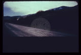
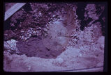
Dropping of street which crossed old landslide failure plane. Note break in slope towards distance in line with fresh scarplet across street. Utility pole is seated along the slide plane.
Image
27
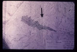
Engineering plan for a proposed reservoir in Salt Lake City. Note the anomalous contour spacing under the arrow. This indicates that the hillside has slid in the past. Construction of a reservoir here would inundate the toe of an ancient landslide and destroy the balance and stability of the weak landslide mass.
Image
28
Erosion caused by release of water on severance of aquaduct in foreground. Timpanogas Cave National Monument Visitor Center lies at bottom of canyon.
Image
29
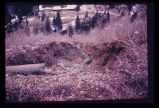
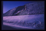
Erosion of a hillside fill- more than 2 feet from a single cloudburst. Sediment is deposited at foot of slope in neighbor's back yard.
Image
30
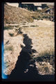
Erosion of fill placed from home construction. Deposition of material in foreground gives braided stream appearance.
Image
31
Excavation and trench cave-ins occur all too frequently along Utah's Wasatch Front. Each year sees its fatalities from this cause.
Image
32
Excavation for a covered distribution reservoir is pointed out in the photo. Note that drainages have been truncated. Reservoir is in an urban area with considerable development downslope. Geologic materials comprising the site are unstable. Geologic faults are mapped bounding the site, and springs issue from excavation walls and floor.
Image
33
Expensive new house being constructed on banks of perennial stream which is subject to flood each spring and throughout the summer. Should not a form of flood plain zoning be in effect?
Image
34
Exposure of a branch of the Wasatch Fault in a sand and gravel pit along the mountain front. Amount of displacement is indeterminable from the stratigraphy exposed. Note that the fault is planar and stands out with relative resistance to the elements despite lack of cementation of the sand and gravel.
Image
35
Failure of front yard before completion of home construction in mountain subdivision.
Image
36
Failure of ground bordering on a covered distribution reservoir. Hammer provides scale on displacement scarp.
Image
37
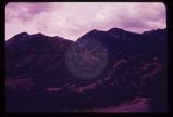
Failure of undisturbed hillside bordering on Bear Lake (to left just off edge of road and photo). This hillside is particularly valuable as view property for resort development, yet is failing without any terrain modification by man.
Image
38
Fault trace of the active Wasatch Fault across a glacial moraine at the mouth of Little Cottonwood Canyon in Salt Lake County. Note that the fault scarplet is virtually unvegetated, indicative of its recency.
Image
39
Fault trace revealed in the foundation excavation for the building depicted in the preceding photograph (p1274n092).
Image
40
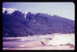
Flooding from snow runoff, mouth of Weber Canyon. Weber River has overtopped its normal channel banks and covers its flood plain. Periodically, structures situated on this flood plain become inundated. Note: ancient Lake Bonneville terraces may be seen on the mountain front.
Image
41
Foothill terrain at base of Wasatch Mountains experienced failure illustrated above.
Image
42
Front end view of the slide (p1274n030).
Image
43
Geologic map of Bear Lake showing the geologic hazards in the area. The active Bear Lake fault zone is outlined in yellow, and landslides in red. Hazardous areas must be given due consideration by planning authorities.
Image
44
Ground subsidence leaves this fireplug supported above the sidewalk in downtown Salt Lake City.
Image
45
Groundwater, boiling up sand, at depth of a few feet in Sugarhouse, Salt Lake City, revealed by foundation excavation. Water probably arises along East Bench branch of the Wasatch Fault.
Image
46
Hebgen Fault scarp near Cabin Creek, aftermath of the 1959 Montana earthquake. Note tilt of trees and the recovery of vegetation over the scarp in only 11 years (photo taken August 1970).
1970-08
Image
47
Hillside subdivision in landslide terrain. Terrain in background has slid in the past. Instrument for measuring ground displacement is housed in box in foreground. White rain gage sits atop instrument housing.
Image
48
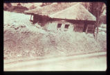
House carried on mud-flow from Davis Creek, Davis County. Historic photo, 1930. Debris covered the highway to a depth of about 6 feet.
1930
Image
49
Hydrograph depicting flow for the year 1945 of Utah's second largest spring, Swan Creek Spring, west of Bear Lake in northern Utah. Note the fluctuation in flow from April to September. Note also rapid response to spring snowmelt (April and May) and rainfall (June and July). The rock from which the spring issues (aquifer) is limestone. The graph illustrates the importance of controlling development on limestone terrain.
Image
50
In the same house; the ceiling is clearly distressed.
Image
26
-
50
of
100
<
1
2
3
4
>