Home
Browse
Ask Us
Chat
Harmful Language Statement
Log in
Advanced Search
Year
1867
1868
1869
1870
1871
1872
1873
1874
1875
1876
1877
1878
1879
1880
1881
1882
1883
1884
1885
1886
1887
1888
1889
1890
1891
1892
1893
1894
1895
1896
1897
1898
1899
1900
1901
1902
1903
1904
1905
1906
1907
1908
1909
1910
1911
1912
1913
1914
1915
1916
1917
1918
1919
1920
1921
1922
1923
1924
1925
1926
1927
1928
1929
1930
1931
1932
1933
1934
1935
1936
1937
1938
1939
1940
1941
1942
1943
1944
1945
1946
1947
1948
1949
1950
1951
1952
1953
1954
1955
1956
1957
1958
1959
1960
1961
1962
1963
1964
1965
1966
1967
1968
1969
1970
1971
1972
1973
1974
1975
1976
1977
1978
1979
1980
1981
1982
1983
1984
1985
1986
1987
1988
1989
1990
1991
1992
1993
1994
1995
1996
1997
1998
1999
2000
2001
2002
2003
2004
2005
2006
2007
2008
2009
2010
2011
2012
2013
2014
2015
2016
2017
2018
2019
2020
2021
2022
2023
2024
TO
1867
1868
1869
1870
1871
1872
1873
1874
1875
1876
1877
1878
1879
1880
1881
1882
1883
1884
1885
1886
1887
1888
1889
1890
1891
1892
1893
1894
1895
1896
1897
1898
1899
1900
1901
1902
1903
1904
1905
1906
1907
1908
1909
1910
1911
1912
1913
1914
1915
1916
1917
1918
1919
1920
1921
1922
1923
1924
1925
1926
1927
1928
1929
1930
1931
1932
1933
1934
1935
1936
1937
1938
1939
1940
1941
1942
1943
1944
1945
1946
1947
1948
1949
1950
1951
1952
1953
1954
1955
1956
1957
1958
1959
1960
1961
1962
1963
1964
1965
1966
1967
1968
1969
1970
1971
1972
1973
1974
1975
1976
1977
1978
1979
1980
1981
1982
1983
1984
1985
1986
1987
1988
1989
1990
1991
1992
1993
1994
1995
1996
1997
1998
1999
2000
2001
2002
2003
2004
2005
2006
2007
2008
2009
2010
2011
2012
2013
2014
2015
2016
2017
2018
2019
2020
2021
2022
2023
2024
Type
Image
3,523
Text
288
Image/StillImage
149
Sound
5
Format
image/jpeg
3,602
application/pdf
1,181
Collection
44th Bomb Group - 8 Ball Tails Magazine
1
Alan K Engen Papers
2
American West Center Research Projects
12
Angus Munn Woodbury Papers
1
Athletics
13
Charles James Nabors Papers
3
Civilian Conservation Corps Newslette...
1
Classified Photographs
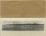
7
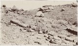
College of Law Publications
54
College of Nursing
13
Colorado Riverbed Case
2
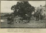
Continuum
7
Cycling Utah
1
Electronic University Archive
49
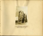
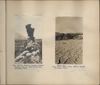
Elias Hicks Blackburn Papers, 1848-1908
2
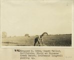
Everett L. Cooley Oral History Project
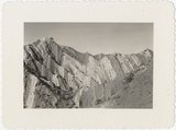
15
Glen Canyon
1
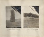
Graduate Nursing Project
1
Hinckley Journal of Politics
1
Historic and Prehistoric Publications
133
Honors Theses Closed Archive
1
Honors Theses Open Access
4
Illuminations
2
Intermountain Ski Instructors Associa...
10
Juanita Brooks Papers
3
Kem C. Gardner Policy Institute Colle...
1
Linford and Richards Family Collection
4
Manuscripts
4
Marriner S. Eccles Papers
19
Marriott Digital Publishing Archive
1
Marriott Library Digital Stacks
1
Marriott Library Items
1
Midvale Museum
1
Mormon Settlement in Arizona
2
NOVEL - Journal of Neuro-Ophthalmology
3
Neighborhood Partners
1
Photo Archives
3,525
Public Affairs of Health Sciences Center
4
Rare Books Collection
7
Theater Programs Collection, 1866-1995
1
Theses & Dissertations
37
UAIDA Main Collection
144
UMFA Docent Archive
1
UScholar Works
7
University of Utah Board of Regents M...
2
University of Utah Press Open Access ...
5
Uranium Oral Histories
1
Utah City Directories Collection
557
Utah Historic Building Records
60
Utah Historical Society Oral History ...
1
Utah Medical Association Bulletin
13
Utah National Register Nomination Forms
1
Utah Pharmacy Digest
6
Utah State Board Of Regents
6
Utah's Urban Pioneer Folk Music Reviv...
1
Utonian Yearbooks
13
Western Waters AZ. vs CA.
1
Western Waters Documents
4
Western Waters NEH
9
More
351
-
375
of
4,783
<
10
11
12
13
14
15
16
17
18
19
>
Gallery view
Number of results to display per page
10
25
50
100
200
Sort by Relevance
Sort by Title A-Z
Sort by Title Z-A
Sort by Date Ascending
Sort by Date Descending
Sort by Last Modified Ascending
Sort by Last Modified Descending
Title
Date
Type
Setname
351
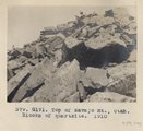
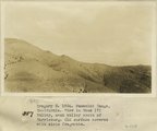
Top of Navajo Mt., Utah. Blocks of quartzite, 1910 (Photo G171)
1910
Image
uum_map
352
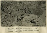
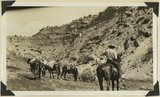
Trail from Lees Ferry to top of plateau east of Paria River, Coconino County, Arizona. June, 1915.
1915
Image
uum_map
353
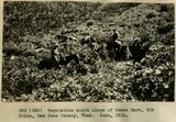
Vegetation south slope of Bears Ears, Elk Ridge, San Juan County, Utah. June, 1915.
1915
Image
uum_map
354
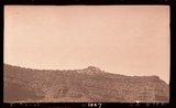
E. Kanab
1936
Image
uum_map
355
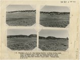
(Panorama A, B, C, D) Blue Springs Meadows. A stream leading south (left) to Mammoth Creek blocked by basalts from Miller Knoll (right sky line) became a lake that eventuallly cut an outlet through the Brian Head formation (upper left).
1944
Image
uum_map
356
Ash, Twin Buttes (Photo G252)
1911
Image
uum_map
357
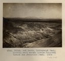
Bad Lands, Cottonwood Wash. 1909 (photograph from Herbert E. Gregory Book 5: Navajo, 1911)
1911
Image
uum_map
358
Dike (diabase), Stiles Ranche, 30± mi. north of Winslow, AZ. 1911 (Photo G236)
1911
Image
uum_map
359
Dinosaur bone in McElmo strata, Yellow Jacket creek, 3± miles north of Holly's ranch, McElmo valley, Colorado. 1910 (Photo N-M77)
1910
Image
uum_map
360
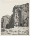
Eroded neck at northwest corner of Moqui Butte area (Photo G233)
1911
Image
uum_map
361
Panorama--4 photographs. Blue Springs meadows. A former valley leading to Mammoth Creek blocked by basalts from Miller Knoll (right skyline) became a lake that eventually cut an outlet northward through the Brian Head formation (upper left). Garfield County, UT, 1944
1944
Image
uum_map
362
Camp in Dry Valley near Henrieville. Garfield County, UT. June 1918
1915
Image
uum_map
363
Escalante School House. United States Geological Survey headquarters 1918. Garfield County, UT. June 1918
1915
Image
uum_map
364
Herbert E. Gregory Book 2: Navajo-Hopi, San Juan 1909
1909
Image
uum_map
365
Herbert E. Gregory Book 4: Navajo, San Juan, 1910
1910
Image
uum_map
366
Herbert E. Gregory Book 6: Navajo, 1913
1913
Image
uum_map
367
Ridge of uptilted strata
1940
Image
uum_map
368
Agathla and Slim (Queen) Rock, Ariz., from S.E. (Photo G144)
1910
Image
uum_map
369
Agathla and Slim (Queen) Rock, Ariz., from S.E. (Photo N-M86)
1910
Image
uum_map
370
Gregory 2, 1924. Death Valley, California. Field at Furnace Creek Ranch. Professor Longwell packing up
1924
Image
uum_map
371
Gregory 3, 1924. Panamint Range, California. View in Wood(?) Valley, next valley south of Harrisburg. Old surface covered with slate fragments
1924
Image
uum_map
372
Plateau south of Block Mesas
1937
Image
uum_map
373
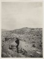
Position of springs in Kitchen Canyon; Todilto (?) strata; water issues from zone between Wingate and Todilto (?), Kane County, Utah, 1931.
1931
Image
uum_map
374
Slim Rock or "The Queen" from the east (Photo G153)
1910
Image
uum_map
375
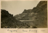
"Dugway," Lees Ferry 1900
1900
Image
uum_map
351
-
375
of
4,783
<
10
11
12
13
14
15
16
17
18
19
>