Home
Browse
Ask Us
Chat
Harmful Language Statement
Log in
Advanced Search
Year
1867
1868
1869
1870
1871
1872
1873
1874
1875
1876
1877
1878
1879
1880
1881
1882
1883
1884
1885
1886
1887
1888
1889
1890
1891
1892
1893
1894
1895
1896
1897
1898
1899
1900
1901
1902
1903
1904
1905
1906
1907
1908
1909
1910
1911
1912
1913
1914
1915
1916
1917
1918
1919
1920
1921
1922
1923
1924
1925
1926
1927
1928
1929
1930
1931
1932
1933
1934
1935
1936
1937
1938
1939
1940
1941
1942
1943
1944
1945
1946
1947
1948
1949
1950
1951
1952
1953
1954
1955
1956
1957
1958
1959
1960
1961
1962
1963
1964
1965
1966
1967
1968
1969
1970
1971
1972
1973
1974
1975
1976
1977
1978
1979
1980
1981
1982
1983
1984
1985
1986
1987
1988
1989
1990
1991
1992
1993
1994
1995
1996
1997
1998
1999
2000
2001
2002
2003
2004
2005
2006
2007
2008
2009
2010
2011
2012
2013
2014
2015
2016
2017
2018
2019
2020
2021
2022
2023
2024
TO
1867
1868
1869
1870
1871
1872
1873
1874
1875
1876
1877
1878
1879
1880
1881
1882
1883
1884
1885
1886
1887
1888
1889
1890
1891
1892
1893
1894
1895
1896
1897
1898
1899
1900
1901
1902
1903
1904
1905
1906
1907
1908
1909
1910
1911
1912
1913
1914
1915
1916
1917
1918
1919
1920
1921
1922
1923
1924
1925
1926
1927
1928
1929
1930
1931
1932
1933
1934
1935
1936
1937
1938
1939
1940
1941
1942
1943
1944
1945
1946
1947
1948
1949
1950
1951
1952
1953
1954
1955
1956
1957
1958
1959
1960
1961
1962
1963
1964
1965
1966
1967
1968
1969
1970
1971
1972
1973
1974
1975
1976
1977
1978
1979
1980
1981
1982
1983
1984
1985
1986
1987
1988
1989
1990
1991
1992
1993
1994
1995
1996
1997
1998
1999
2000
2001
2002
2003
2004
2005
2006
2007
2008
2009
2010
2011
2012
2013
2014
2015
2016
2017
2018
2019
2020
2021
2022
2023
2024
Type
Image
3,523
Text
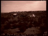
287
Image/StillImage
149
Sound
5
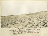
Format
image/jpeg
3,602
application/pdf
1,184
Collection
44th Bomb Group - 8 Ball Tails Magazine
1
Alan K Engen Papers
2
American West Center Research Projects
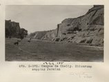
12
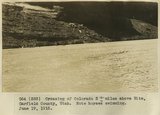
Angus Munn Woodbury Papers
1
Anthropological Papers
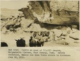
5
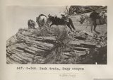
Athletics
13
Charles James Nabors Papers
3
Civilian Conservation Corps Newslette...
1
Classified Photographs
7
College of Law Publications
54
College of Nursing
13
Colorado Riverbed Case
2
Continuum
7
Cycling Utah
1
Electronic University Archive
49
Elias Hicks Blackburn Papers, 1848-1908
2
Everett L. Cooley Oral History Project
15
Glen Canyon
1
Graduate Nursing Project
1
Hinckley Journal of Politics
1
Historic and Prehistoric Publications
133
Honors Theses Closed Archive
1
Honors Theses Open Access
4
Illuminations
2
Intermountain Ski Instructors Associa...
10
Juanita Brooks Papers
3
Kem C. Gardner Policy Institute Colle...
1
Linford and Richards Family Collection
4
Manuscripts
4
Marriner S. Eccles Papers
19
Marriott Digital Publishing Archive
1
Marriott Library Digital Stacks
1
Marriott Library Items
1
Midvale Museum
1
Mormon Settlement in Arizona
2
NOVEL - Journal of Neuro-Ophthalmology
1
Neighborhood Partners
1
Photo Archives
3,525
Public Affairs of Health Sciences Center
4
Rare Books Collection
7
Theater Programs Collection, 1866-1995
1
Theses & Dissertations
37
UAIDA Main Collection
144
UMFA Docent Archive
1
UScholar Works
7
University of Utah Board of Regents M...
2
University of Utah Press Open Access ...
5
Uranium Oral Histories
1
Utah City Directories Collection
557
Utah Historic Building Records
60
Utah Historical Society Oral History ...
1
Utah Medical Association Bulletin
13
Utah National Register Nomination Forms
1
Utah Pharmacy Digest
6
Utah State Board Of Regents
6
Utah's Urban Pioneer Folk Music Reviv...
1
Utonian Yearbooks
13
Western Waters AZ. vs CA.
1
Western Waters Documents
4
Western Waters NEH
9
More
326
-
350
of
4,786
<
9
10
11
12
13
14
15
16
17
18
>
Gallery view
Number of results to display per page
10
25
50
100
200
Sort by Relevance
Sort by Title A-Z
Sort by Title Z-A
Sort by Date Ascending
Sort by Date Descending
Sort by Last Modified Ascending
Sort by Last Modified Descending
Title
Date
Type
Setname
326
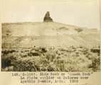
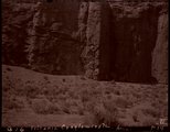
Slim Rock or "Queen Rock," La Plata outlier on Dolores near Agathla Needle, Ariz., 1909 (photo G-108)
1909
Image
uum_map
327
Snake dance: a rattlesnake
1900
Image
uum_map
328
Spur bearing gravel, Bright Angel Creek, 1928
1928
Image
uum_map
329
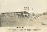
Store and well, Cornfields south of Ganado, Ariz., 1909 (sheet G-61)
1909
Image
uum_map
330
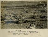
Structure of alluvium, Canyon Bonito, near Fort Defiance, Ariz., 1909 (photo G-10)
1909
Image
uum_map
331
SW Sunrise Springs, Arizona (Negative for photo G-43)
1909
Image
uum_map
332
Tertiary clay shales near Sunrise Springs and Indian Wells (Negative for photo G-46)
1909
Image
uum_map
333
Top of Black Mesa, Onion Spgs. (Negative for photo G-95)
1909
Image
uum_map
334
Typical vegetation, elevation 5000-5500 feet, between St. Michaels and Ganado, Ariz., 1909 (photo G-34)
1909
Image
uum_map
335
Vegetation, Black Creek Valley, Arizona, 1909 (photo G-11)
1909
Image
uum_map
336
View, Fort Defiance-Tolhatchie road (negative for photo G-104)
1909
Image
uum_map
337
Volcanic conglomerate, Ariz. (negative for photo G-16)
1909
Image
uum_map
338
Webo Spgs., water from Mesa Verde sandstones (negative for photo G-97)
1909
Image
uum_map
339
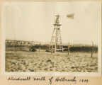
Windmill north of Holbrook, 1909
1909
Image
uum_map
340
Windmills with points driven into alluvial sand, 10± miles north of Holbrook, Ariz., 1909 (photo G-79)
1909
Image
uum_map
341
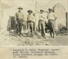
Longwell 7, 1924. Shoshone, Amoragosa Valley. Professor Gregory, Rocky Mountain George, Dr. Noble, Dr. Hewett
1924
Image
uum_map
342
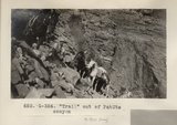
"Trail" out of PahUte canyon (Photo G354)
1913
Image
uum_map
343
Camp and Indian pasture, Da-dat-soe. East terrace of Choiskai Mt., NM. 1911
1911
Image
uum_map
344
Camp south edge of Elk Ridge at head of Grand Gulch, San Juan County, Utah. June, 1915.
1915
Image
uum_map
345
Canyon de Chelly. Shinarump capping Permian (Photo G373)
1913
Image
uum_map
346
Crossing of Colorado River 3+ miles above Hite, Garfield County, Utah. Note horses swimming. June 19, 1915.
1915
Image
uum_map
347
Dike east of Dike no. 2, Laguna Creek valley, Ariz., 1910 (Photo N-M87)
1910
Image
uum_map
348
Looking east from base of Choiskai Mt., Tohatchie valley in distance. H.E.G. and Grover Cleveland. Heald, photo. 1911 (Photo N-M110)
1911
Image
uum_map
349
Outfit at head of "Cliff" Canyon, Kaiparowitz Plateau, Kane County, Utah. Dakota sandstone, Mancos and Mesa Verde strata in distance. June 10, 1915.
1915
Image
uum_map
350
Pack train, Sagy canyon (Photo G348)
1913
Image
uum_map
326
-
350
of
4,786
<
9
10
11
12
13
14
15
16
17
18
>