|
|
Title | Collection Number And Name | Photo Number |
| 326 |
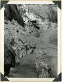
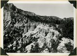 |
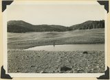
Same as 2751, shows eroded top of Sevier Plateau | P0013 Herbert E. Gregory Photograph Collection | P0013n11_148_2752 |
| 327 |
 |
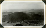
Same as 2776. Looking north across Coal Creek Canyon. Sugar Loaf on middle skyline | P0013 Herbert E. Gregory Photograph Collection | P0013n11_161_2778 |
| 328 |
 |
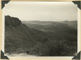
Same as 2776. Looking northeast to edge of Markagunt Plateau | P0013 Herbert E. Gregory Photograph Collection | P0013n11_161_2777 |
| 329 |
 |
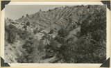
Same as 2779. Detail contact of conglomerate (foreground) and rough bedded, carbonaceous sandstone above | P0013 Herbert E. Gregory Photograph Collection | P0013n11_164_2782 |
| 330 |
 |
Same as 2779. Detail contact of conglomerate (foreground) and rough bedded, carbonaceous sandstone above | P0013 Herbert E. Gregory Photograph Collection | P0013n11_163_2780 |
| 331 |
 |
Same as 2779. Detail contact of conglomerate (foreground) and rough bedded, carbonaceous sandstone above | P0013 Herbert E. Gregory Photograph Collection | P0013n11_163_2781 |
| 332 |
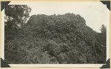 |
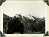
Scoriaceous material near vent of volcanic Black Knoll | P0013 Herbert E. Gregory Photograph Collection | P0013n11_117_2707 |
| 333 |
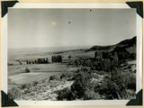 |
Settlement of Moccasin Springs looking eastward toward Kaibab Indian School. Kaibab Plateau on skyline. Mohave County, AZ. 1939 | P0013 Herbert E. Gregory Photograph Collection | P0013n11_099_2688 |
| 334 |
 |
Sevier fault in gully east of Mt. Carmel Junction. Tropic shale, rounded hills (left); Navajo sandstone in fracture zone (right). Kane County, UT | P0013 Herbert E. Gregory Photograph Collection | P0013n11_029_2570 |
| 335 |
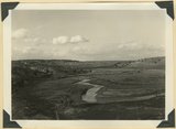 |
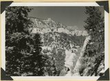
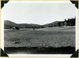
Sevier River Valley north of Hatch, UT | P0013 Herbert E. Gregory Photograph Collection | P0013n11_124_2713 |
| 336 |
 |
Sheep Creek at head of box canyon. Navajo sandstone (foreground) followed by Carmel and Entrada. Kane County, UT, 1940 | P0013 Herbert E. Gregory Photograph Collection | P0013n11_113_2704 |
| 337 |
 |
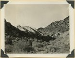
Shinarump and Moenkopi beds disturbed by a local fault 3 miles north of Fredonia, Coconino County, AZ. 1939 | P0013 Herbert E. Gregory Photograph Collection | P0013n11_069_2641 |
| 338 |
 |
Shnabkaib member (left) and upper red beds of Moenkopi formation, Taylor Creek. Washington County, UT, 1940 | P0013 Herbert E. Gregory Photograph Collection | P0013n11_144_2743 |
| 339 |
 |
Shnabkaib member of the Moenkopi formation upturned in a fold which involves upper red beds (right), Coal Canyon. Iron County, UT. 1940 | P0013 Herbert E. Gregory Photograph Collection | P0013n11_136_2729 |
| 340 |
 |
Shnabkaib member of the Moenkopi formation upturned in a fold which involves upper red beds (right), Coal Canyon. Iron County, UT. 1940 | P0013 Herbert E. Gregory Photograph Collection | P0013n11_135_2728 |
| 341 |
 |
Short Creek near the exit from its canyon, in Vermillion Cliffs. Alluvial terraces and broad channel made during past 50 years, Mohave County, AZ, 1939 | P0013 Herbert E. Gregory Photograph Collection | P0013n11_076_2654 |
| 342 |
 |
Sidney Valley. Ponds and mounds produced by glaciation. Iron County | P0013 Herbert E. Gregory Photograph Collection | P0013n11_158_2771 |
| 343 |
 |
Sidney Valley. Ponds and mounds produced by glaciation. Iron County | P0013 Herbert E. Gregory Photograph Collection | P0013n11_157_2770 |
| 344 |
 |
Smith Mesa viewed from the northeast, mesa top developed on Springdale member of the Chinle formation; upper Chinle and Navajo (right), La Verkin Canyon (left), Hurricane Cliffs (on skyline) | P0013 Herbert E. Gregory Photograph Collection | P0013n11_142_2740 |
| 345 |
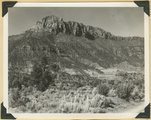 |
Smithsonian Butte from north base. Chinle, including Springdale member (middle ledge), Wingate? and Kayenta?, Navajo top. Washington County, UT | P0013 Herbert E. Gregory Photograph Collection | P0013n11_028_2568 |
| 346 |
 |
Solution channels in Wingate sandstone, Capitol Gorge. Wayne County, UT | P0013 Herbert E. Gregory Photograph Collection | P0013n11_035_2582 |
| 347 |
 |
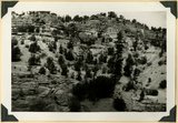
South wall of Rock Canyon. Kaibab (on valley floor and up to first ledge), conglomerate, Moenkopi (upper part of slope and the cliffs), Mohave County, AZ, 1939 | P0013 Herbert E. Gregory Photograph Collection | P0013n11_076_2653 |
| 348 |
 |
South wall of Timpoweap Canyon near mouth of Alkali Wash. Kaibab limestone (base), two beds of conglomerate separated by erosion surface, Moenkopi limestone top, Washington County, UT. 1939 | P0013 Herbert E. Gregory Photograph Collection | P0013n11_072_2646 |
| 349 |
 |
Spendlove Knoll, volcanic cone on Navajo sandstone, head of Hop Valley. Washington County, UT, 1940 | P0013 Herbert E. Gregory Photograph Collection | P0013n11_143_2742 |
| 350 |
 |
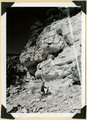
Spring (lower left) on local fault marked by displacement and slickensides (lower left), Johnson Canyon, Kane County, UT, 1939 | P0013 Herbert E. Gregory Photograph Collection | P0013n11_078_2657 |