Home
Browse
Ask Us
Chat
Harmful Language Statement
Log in
Photo Archives
Advanced Search
About
Over 70,000 photos covering a variety of topics from Marriott Library Special Collections
Year
1872
1873
1874
1875
1876
1877
1878
1879
1880
1881
1882
1883
1884
1885
1886
1887
1888
1889
1890
1891
1892
1893
1894
1895
1896
1897
1898
1899
1900
1901
1902
1903
1904
1905
1906
1907
1908
1909
1910
1911
1912
1913
1914
1915
1916
1917
1918
1919
1920
1921
1922
1923
1924
1925
1926
1927
1928
1929
1930
1931
1932
1933
1934
1935
1936
1937
1938
1939
1940
1941
1942
1943
1944
1945
1946
1947
1948
1949
1950
1951
1952
1953
1954
1955
1956
1957
1958
1959
1960
1961
1962
1963
1964
1965
1966
1967
1968
1969
1970
1971
1972
1973
1974
1975
1976
1977
1978
1979
1980
1981
1982
1983
1984
1985
1986
1987
1988
1989
1990
1991
1992
1993
TO
1872
1873
1874
1875
1876
1877
1878
1879
1880
1881
1882
1883
1884
1885
1886
1887
1888
1889
1890
1891
1892
1893
1894
1895
1896
1897
1898
1899
1900
1901
1902
1903
1904
1905
1906
1907
1908
1909
1910
1911
1912
1913
1914
1915
1916
1917
1918
1919
1920
1921
1922
1923
1924
1925
1926
1927
1928
1929
1930
1931
1932
1933
1934
1935
1936
1937
1938
1939
1940
1941
1942
1943
1944
1945
1946
1947
1948
1949
1950
1951
1952
1953
1954
1955
1956
1957
1958
1959
1960
1961
1962
1963
1964
1965
1966
1967
1968
1969
1970
1971
1972
1973
1974
1975
1976
1977
1978
1979
1980
1981
1982
1983
1984
1985
1986
1987
1988
1989
1990
1991
1992
1993
Type
Image
3,451
Format
image/jpeg
3,451
Collection
Photo Archives
3,451
Filters:
Collection Name:
"Herbert E. Gregory"
Format:
"image/jpeg"
Type:
"Image"
326
-
350
of
3,451
<
9
10
11
12
13
14
15
16
17
18
>
Gallery view
Number of results to display per page
10
25
50
100
200
Sort by Relevance
Sort by Title A-Z
Sort by Title Z-A
Sort by Date Ascending
Sort by Date Descending
Sort by Last Modified Ascending
Sort by Last Modified Descending
Title
Date
Type
326
Buells Park, 12± north of Ft. Defiance, looking toward west rim. Hill of peridotite bearing gem peridots and garnets in center, 1908 (D. B. Sterrett photo USGS)
1908
Image
327
Buells Park, N. Ft. Defiance (negative for photo G-24)
1909
Image
328
Buells Park, N. Ft. Defiance (negative for photo G-27)
1909
Image
329
Buells Park, north of Fort Defiance, D. B. Sterrett photo USGS, 1908
1908
Image
330
Building raft on San Juan River, July 1909
1909
Image
331
Building raft on San Juan River, July 1909
1909
Image
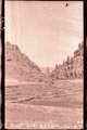
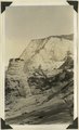
332
Burro Gap on East Fork of Sevier River above mouth of Deer Creek. Locus of Paunsaugunt fault; upthrow on east right. Garfield County, UT. 1943
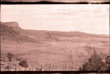
1943
Image
333
Burro, Ganado, Ariz. 1909
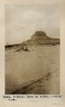
1909
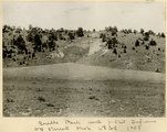
Image
334
Burros, San Juan Valley, 1910 (Photo N-M78)
1910
Image
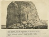
335
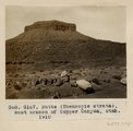
Butte (Moencopie strata), east branch of Copper Canyon, Utah, 1910 (Photo G167)
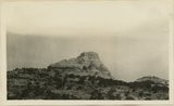
1910
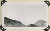
Image
336
Butte eroded from Navajo sandstone, capped by iron concretion, Zion-Mount Carmel highway, Kane County, Utah, 1931.
1931
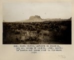
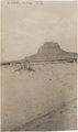
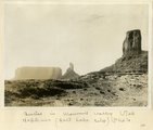
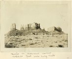
Image
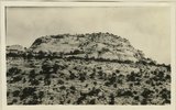
337
Butte of Coconino near junction Beef Basin and Fable Valley. San Juan County, UT, 1928
1928
Image
338
Butte of Coconino near mouth of Fable Valley. San Juan County, UT, 1928
Image
339
Butte of Coconino near mouth of Fable Valley. San Juan County, UT, 1928
1928
Image
340
Butte of Moenkopi standing on Coconino(?) between Snow Flat and Kane Draw. San Juan County, UT, 1927
1927
Image
341
Butte of Morrison shale capped by Dakota rising from a floor of Morrison(?) sand stone(Salt Wash). Near Mouth of Recapture Creek. San Juan County, UT, 1928
1928
Image
342
Butte, 3± mi. west of Stiles Ranche (Photo G238)
1911
Image
343
Butte, 3± mi. west of Stiles Ranche (Photo G238)
1911
Image
344
Butte, composed of massive white rock below Dakota. Note horse and rider. Lower Wahweap Valley. Kane County, UT. 1922
1922
Image
345
Butte, junction Sagy canyon with middle of East Branch, Ariz., 1910 (Photo G162)
1910
Image
346
Butte, LaPlata on Dolores, 12+ mi. south of Oljato, Utah. Agathla Needle and QueenRock in distance, 1910 (Photo G159)
1910
Image
347
Butte, LaPlata on Dolores, 12+ mi. south of Oljato, Utah. Agathla Needle in distance, 1910 (Photo N-M91A)
1910
Image
348
Butte, LaPlata on Dolores, 12± mi. south of Oljato, Utah. Agathla Needle in distance, 1910
1910
Image
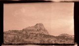
349
Buttes in Monument Valley, Utah (Hopkins, Salt Lake City, photo)
1909
Image
350
Buttes in Monument Valley, Utah (Hopkins, Salt Lake City, photo)
1909
Image
326
-
350
of
3,451
<
9
10
11
12
13
14
15
16
17
18
>