Home
Browse
Ask Us
Chat
Harmful Language Statement
Log in
Photo Archives
Advanced Search
About
Over 70,000 photos covering a variety of topics from Marriott Library Special Collections
Year
1872
1873
1874
1875
1876
1877
1878
1879
1880
1881
1882
1883
1884
1885
1886
1887
1888
1889
1890
1891
1892
1893
1894
1895
1896
1897
1898
1899
1900
1901
1902
1903
1904
1905
1906
1907
1908
1909
1910
1911
1912
1913
1914
1915
1916
1917
1918
1919
1920
1921
1922
1923
1924
1925
1926
1927
1928
1929
1930
1931
1932
1933
1934
1935
1936
1937
1938
1939
1940
1941
1942
1943
1944
1945
1946
1947
1948
1949
1950
1951
1952
1953
1954
1955
1956
1957
1958
1959
1960
1961
1962
1963
1964
1965
1966
1967
1968
1969
1970
1971
1972
1973
1974
1975
1976
1977
1978
1979
1980
1981
1982
1983
1984
1985
1986
1987
1988
1989
1990
1991
1992
1993
TO
1872
1873
1874
1875
1876
1877
1878
1879
1880
1881
1882
1883
1884
1885
1886
1887
1888
1889
1890
1891
1892
1893
1894
1895
1896
1897
1898
1899
1900
1901
1902
1903
1904
1905
1906
1907
1908
1909
1910
1911
1912
1913
1914
1915
1916
1917
1918
1919
1920
1921
1922
1923
1924
1925
1926
1927
1928
1929
1930
1931
1932
1933
1934
1935
1936
1937
1938
1939
1940
1941
1942
1943
1944
1945
1946
1947
1948
1949
1950
1951
1952
1953
1954
1955
1956
1957
1958
1959
1960
1961
1962
1963
1964
1965
1966
1967
1968
1969
1970
1971
1972
1973
1974
1975
1976
1977
1978
1979
1980
1981
1982
1983
1984
1985
1986
1987
1988
1989
1990
1991
1992
1993
Type
Image
3,451
Format
image/jpeg
3,451
Collection Name
Herbert E. Gregory
3,451
Filters:
Collection Name:
"Herbert E. Gregory"
Collection:
"uum_map"
Format:
image
Setname:
!(ir* OR ehsl*)
301
-
325
of
3,451
<
8
9
10
11
12
13
14
15
16
17
>
Gallery view
Number of results to display per page
10
25
50
100
200
Sort by Relevance
Sort by Title A-Z
Sort by Title Z-A
Sort by Date Ascending
Sort by Date Descending
Sort by Last Modified Ascending
Sort by Last Modified Descending
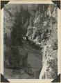
Sort by Photo Number
Title
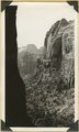
Collection Number And Name
Photo Number
301
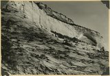
Moenkopi formation showing in succession Shnabkaib, lower red, Virgin limestone (double rich), middle red, Shnabkaib, and upper red member; Shinarump conglomerate (crest and top of cuesta), Chinle including Springdale member (low cliff, upper left): Taylor Creek. Washington County, UT, 1940
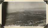
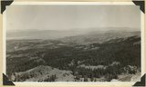
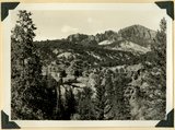
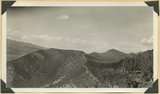
P0013 Herbert E. Gregory Photograph Collection
P0013n11_146_2748
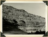
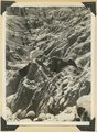
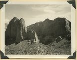
302
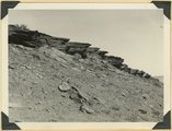
Moenkopi showing typical erosion of its shaly sandstones on Hurricane-Antelope Springs Road, Mohave County, AZ. 1939
P0013 Herbert E. Gregory Photograph Collection
P0013n11_074_2649
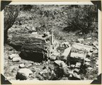
303
Mouth of Camp Creek. Resistant limestones of lowest Triassic make walls. Iron County, UT. 1941
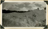
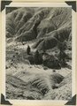
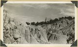
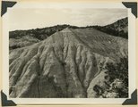
P0013 Herbert E. Gregory Photograph Collection
P0013n11_159_2773
304
Mouth of Timpoweap Canyon of Virgin River looking east upstream. Kaibab and Moenkopi strata also basalt (upper left). Hurricane fault trends north-south in foreground. Washington County, UT, 1939
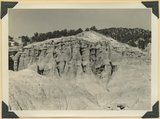
P0013 Herbert E. Gregory Photograph Collection
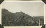
P0013n11_071_2644
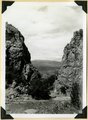
305
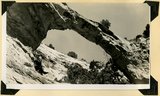
Natural bridge near top of wall of Ashdown Canyon, Iron County, UT, 1941
P0013 Herbert E. Gregory Photograph Collection
P0013n11_153_2762
306
Navajo sandstone including Temple cap member (top). Shows typical recessed arch. Near east entrance, Zion Park, Kane County, UT. 1939
P0013 Herbert E. Gregory Photograph Collection
P0013n11_094_2680
307
Navajo sandstone viewed from tunnel window across Pine Creek. The Sentinel in distance. Zion National Park
P0013 Herbert E. Gregory Photograph Collection
P0013n11_026_2564
308
North Rim of canyon, Wasatch limestone. Iron Mountain in distance west. Cedar Breaks National Monument
P0013 Herbert E. Gregory Photograph Collection
P0013n11_031_2574
309
Northern edge Kanab Plateau. Village of Fredonia on surface eroded from lower Moenkopi beds and crossed by Kanab Creek. Buttes of Moenkopi capped by Shinarump (right), Coconino County, August, 1939
P0013 Herbert E. Gregory Photograph Collection
P0013n11_067_2637
310
Northernmost of three Flax Lakes on high divide between Kanab and Parunuweap Valleys. In Cretaceous beds. Looking northeast across head of Kanab Valley to Pink Cliffs (Tertiary), Kane County, UT. 1939
P0013 Herbert E. Gregory Photograph Collection
P0013n11_059_2624
311
Panorama northwest of Brian Head, Markagunt Plateau. Glacial topography foreground; Wasatch formation (middle distance); Little Salt Lake in valley beyond Hurricane Cliffs. Iron County, UT
P0013 Herbert E. Gregory Photograph Collection
P0013n11_031_2575
312
Panorama northwest of Brian Head, Markagunt Plateau. Glacial topography foreground; Wasatch formation (middle distance); Little Salt Lake in valley beyond Hurricane Cliffs. Iron County, UT
P0013 Herbert E. Gregory Photograph Collection
P0013n11_032_2576
313
Panorama of Ashdown Canyon, 600-1800 feet deep, 20-150 feet wide out in Straight Cliffs sandstone. Iron County, UT, 1941
P0013 Herbert E. Gregory Photograph Collection
P0013n11_152_2759
314
Panorama of Ashdown Canyon, 600-1800 feet deep, 20-150 feet wide out in Straight Cliffs sandstone. Iron County, UT, 1941
P0013 Herbert E. Gregory Photograph Collection
P0013n11_152_2760
315
Permian-Triassic contact in Goulds Canyon (of little Creek). Kaibab (lowest ledge), conglomerate (second ledge), Moenkopi (third ledge and top). Washington County, UT. 1939
P0013 Herbert E. Gregory Photograph Collection
P0013n11_073_2647
316
Petrified forest member of the Chinle formation, Taylor Creek. Washington County, UT, 1940
P0013 Herbert E. Gregory Photograph Collection
P0013n11_145_2746
317
Petrified log near base of Chinle, north of Rockville. Zion National Park
P0013 Herbert E. Gregory Photograph Collection
P0013n11_028_2569
318
Post Wasatch Sevier(?) formation (foreground and center) capped by lavas of Sevier Plateau (horizon) at head of north fork of Linekiln Wash. Garfield County, UT, 1940
P0013 Herbert E. Gregory Photograph Collection
P0013n11_132_2722
319
Post-Wasatch Sevier(?) formation, lower part: erosion features of clays and silts
P0013 Herbert E. Gregory Photograph Collection
P0013n11_134_2726
320
Post-Wasatch Sevier(?) formation, lower part: erosion features of clays and silts
P0013 Herbert E. Gregory Photograph Collection
P0013n11_135_2727
321
Post-Wasatch Sevier(?) formation, lower part: erosion features of clays and silts
P0013 Herbert E. Gregory Photograph Collection
P0013n11_134_2725
322
Post-Wasatch Sevier(?) formation, lower part: erosion features of clays and silts
P0013 Herbert E. Gregory Photograph Collection
P0013n11_133_2724
323
Post-Wasatch Sevier(?) formation, upper part) green sandstone in columns, white, cherty limestone and lava(top)
P0013 Herbert E. Gregory Photograph Collection
P0013n11_133_2723
324
Ridge of Shinarump conglomerate (center) extending from Taylor Creek to Camp Creek; Moenkopi (cliffs and slopes) at left, Chinle Valley at right. Washington County, UT, 1940
P0013 Herbert E. Gregory Photograph Collection
P0013n11_147_2749
325
Same as 2738. Walls and towers of Navajo sandstone; Chinle formation on slopes
P0013 Herbert E. Gregory Photograph Collection
P0013n11_141_2739
301
-
325
of
3,451
<
8
9
10
11
12
13
14
15
16
17
>