Home
Browse
Ask Us
Chat
Harmful Language Statement
Log in
Advanced Search
Year
1872
1873
1874
1875
1876
1877
1878
1879
1880
1881
1882
1883
1884
1885
1886
1887
1888
1889
1890
1891
1892
1893
1894
1895
1896
1897
1898
1899
1900
1901
1902
1903
1904
1905
1906
1907
1908
1909
1910
1911
1912
1913
1914
1915
1916
1917
1918
1919
1920
1921
1922
1923
1924
1925
1926
1927
1928
1929
1930
1931
1932
1933
1934
1935
1936
1937
1938
1939
1940
1941
1942
1943
1944
1945
1946
1947
1948
1949
1950
1951
1952
1953
1954
1955
1956
1957
1958
1959
1960
1961
1962
1963
1964
1965
1966
1967
1968
1969
1970
1971
1972
1973
1974
1975
1976
1977
1978
1979
1980
1981
1982
1983
1984
1985
1986
1987
1988
1989
1990
1991
1992
1993
TO
1872
1873
1874
1875
1876
1877
1878
1879
1880
1881
1882
1883
1884
1885
1886
1887
1888
1889
1890
1891
1892
1893
1894
1895
1896
1897
1898
1899
1900
1901
1902
1903
1904
1905
1906
1907
1908
1909
1910
1911
1912
1913
1914
1915
1916
1917
1918
1919
1920
1921
1922
1923
1924
1925
1926
1927
1928
1929
1930
1931
1932
1933
1934
1935
1936
1937
1938
1939
1940
1941
1942
1943
1944
1945
1946
1947
1948
1949
1950
1951
1952
1953
1954
1955
1956
1957
1958
1959
1960
1961
1962
1963
1964
1965
1966
1967
1968
1969
1970
1971
1972
1973
1974
1975
1976
1977
1978
1979
1980
1981
1982
1983
1984
1985
1986
1987
1988
1989
1990
1991
1992
1993
Type
Image
3,521
Image/StillImage
143
Format
image/jpeg
3,594
application/pdf
70
Collection
Photo Archives
3,521
UAIDA Main Collection
143
Filters:
Collection Name:
"Herbert E. Gregory"
276
-
300
of
3,664
<
7
8
9
10
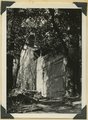
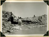
11
12
13
14
15
16
>
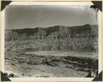
Gallery view
Number of results to display per page
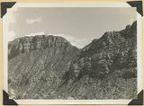
10
25
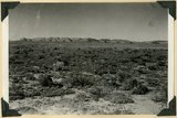
50
100
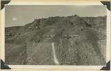
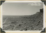
200
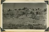
Sort by Relevance
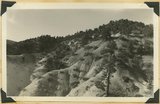
Sort by Title A-Z
Sort by Title Z-A
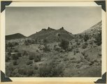
Sort by Date Ascending
Sort by Date Descending
Sort by Last Modified Ascending
Sort by Last Modified Descending
Title
Date
Type
Setname
276
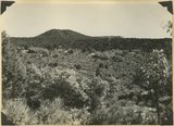
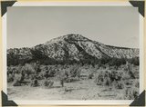
Corral Knoll volcanic cone, Kanab Valley, Kane County, Carmel limestone covered with lava (foreground), Cretaceous cliffs distance, Kane Co., UT. 1939
1939
Image
uum_map
277
Cottonwood trees buried by sand dunes; trunks reexposed by recent excavations of alluvial valley fill, Short Creek, Mohave County, AZ, 1939
1939
Image
uum_map
278
Cougar Mountain fault. Springdale member of Chinle (lower left) abutting against base of Navajo (lower right), Washington County, UT, 1939
1939
Image
uum_map
279
Cowboy Butte 2 miles north of Fredonia. Moenkopi (Shnabkaib member at base) and Shinarump, Coconino County, AZ. 1939
1939
Image
uum_map
280
Divide dike basalt intruded in Moenkopi beds, head of Workman Wash, Washington County, UT, 1939
1939
Image
uum_map
281
Door of "Winsor Castle," Pipe Springs, Mohave County, Ariz. 1939
1939
Image
uum_map
282
East Creek Valley, Union Pacific pump house
1939; 1940
Image
uum_map
283
Edge of basalt flow over eroded Moenkopi along highway west of Grafton, Washington County, UT, 1939
1939
Image
uum_map
284
Entrada formation. Gypsiferous Curtis at top. Near mouth of Crystal Creek, Washington County, UT, 1939
1939
Image
uum_map
285
Entrada sandstone (bottom) in contact with shales and gypsum of Curtis formation, Paria Valley 4 miles south of Cannonville, Kane County, UT. 1939
1939
Image
uum_map
286
Entrada, Curtis, and Winsor formation overlain by Dakota (extreme top), Alton-Skutumpah road, Kane County, UT, 1939
1939
Image
uum_map
287
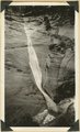
Ephemeral waterfall, disappears about half hour after rain. Pine Creek, Zion National Park, 1937
1937
Image
uum_map
288
Eroded alluvial fill 60 feet thick in Kanab Creek. In 1884 stream ran at top of terrace, Kane Co., Utah, 1939
1939
Image
uum_map
289
Eroded edge of basalt flow from Bald Knoll. White Cliffs, Navajo sandstone (upper right); middle Johnson Canyon. Kane County, UT, 1940
1940
Image
uum_map
290
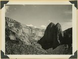
Erosion features near the head of Taylor Creek, towers and walls of Navajo sandstone overlaid by Carmel limestone and lavas (top right and center). Washington County, UT, 1940
1940
Image
uum_map
291
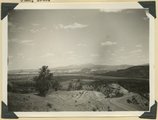
Erosion of Cretaceous beds in Paria Valley east of Tropic; Wasatch formation on horizon. View looking east near mouth of Henderson Valley. Garfield County, UT. 1940
1940
Image
uum_map
292
Erosion on Mancos shales, branch of Fremont River above Cainesville. Wayne County, UT
1938; 1939
Image
uum_map
293
Erosion remnants in upper (white) part of Wasatch formation: limestone and conglomerate. Castle Wash an upper tributary to Sevier River. Kane County, UT, 1940
1940
Image
uum_map
294
Erosion surface at edge of Vermillion Cliffs west of Pipe Springs, Mohave County, AZ. Streams cross Sevier fault from downthrow to upthrow side. 1939
1939
Image
uum_map
295
Erosion surface on lower Chinle beds at base of Vermillion Cliffs, traversed by Kanab Creek (left center), Kane County, UT. 1939
1939
Image
uum_map
296
Erosion surface produced by bevelling Chinle strata at the base of Vermillion Cliffs south of Cane Beds, Mohave County, AZ, 1939
1939
Image
uum_map
297
Falls in Kanab Creek near Corral Knoll. Carmel formation. Ancient channel of the Kanab filled with alluvium. Kane County, UT, 1939
1939
Image
uum_map
298
Fault at Mt. Carmel Junction, looking southeast. Carmel limestone on upthrown side (middle); Entrada (foreground). Kane County, UT, 1939
1939
Image
uum_map
299
Fault in Jurassic formations 3 miles south of Mt. Carmel. Carmel limestone (left). Entrada and Carmel (right). Elkheart Cliffs (Navajo) (upper right). Kane County, UT, 1939
1939
Image
uum_map
300
Fault in lower Moenkopi shaly sandstone head of Rock Canyon (of Short Creek), Mohave County, AZ, 1939
1939
Image
uum_map
276
-
300
of
3,664
<
7
8
9
10
11
12
13
14
15
16
>