|
|
Title | Collection Number And Name | Photo Number |
| 276 |
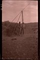 |
Hand drill, Chinlee Valley (Negative for photo G-39) | P0013 Herbert E. Gregory Photograph Collection | P0013n02_026_244_neg |
| 277 |
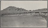 |
Pueblo Colorado Wash, Ganado, Arizonal, Dolores strata, 1909 (photo G-38) | P0013 Herbert E. Gregory Photograph Collection | P0013n02_026_245 |
| 278 |
 |
Pueblo Colorado Wash, Ganado, Arizonal, Dolores strata, 1909 (photo G-38) | P0013 Herbert E. Gregory Photograph Collection | P0013n02_026_245 |
| 279 |
 |
Dug well, Cornfields, south of Ganado, Ariz., 1909 (photo G-40) | P0013 Herbert E. Gregory Photograph Collection | P0013n02_027_246 |
| 280 |
 |
Dug well, Cornfields, Ganado, Ariz. (Negative for photo G-40) | P0013 Herbert E. Gregory Photograph Collection | P0013n02_027_246_neg |
| 281 |
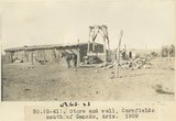 |
Store and well, Cornfields south of Ganado, Ariz., 1909 (sheet G-61) | P0013 Herbert E. Gregory Photograph Collection | P0013n02_027_247 |
| 282 |
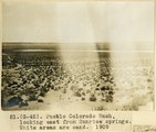 |
Pueblo Colorado Wash, looking east from Sunrise Springs. White areas are sand, 1909 (photo G-42) | P0013 Herbert E. Gregory Photograph Collection | P0013n02_028_248 |
| 283 |
 |
Pueblo Colorado Wash, 1909 (negative for photo G-42) | P0013 Herbert E. Gregory Photograph Collection | P0013n02_028_248_neg |
| 284 |
 |
Unconformity, McElmo (?) on La Plata (?) or in 2± mil. southwest of Sunrise Spgs., Arizona (photo G-43) | P0013 Herbert E. Gregory Photograph Collection | P0013n02_028_249 |
| 285 |
 |
Unconformity, McElmo (?) on La Plata (?) or in 2± mil. southwest of Sunrise Spgs., Arizona (photo G-43) | P0013 Herbert E. Gregory Photograph Collection | P0013n02_028_249 |
| 286 |
 |
SW Sunrise Springs, Arizona (Negative for photo G-43) | P0013 Herbert E. Gregory Photograph Collection | P0013n02_028_249_neg |
| 287 |
 |
Ancient landslides, 5± mi. southwest of Sunrise Spgs., Ariz. (photo G-44) | P0013 Herbert E. Gregory Photograph Collection | P0013n02_029_250 |
| 288 |
 |
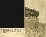
Tertiary clay shales interbedded with tuff. "Black Rock" between Sunrise Springs and Biddehoche (Indian wells), Ariz., 1909 (photo G-45) | P0013 Herbert E. Gregory Photograph Collection | P0013n02_029_251 |
| 289 |
 |
The same as G-45: Tertiary clay shales interbedded with tuff. "Black Rock" between Sunrise Springs and Biddehoche (Indian wells), Ariz., 1909 (photo G-46) | P0013 Herbert E. Gregory Photograph Collection | P0013n02_030_252 |
| 290 |
 |
Tertiary clay shales near Sunrise Springs and Indian Wells (Negative for photo G-46) | P0013 Herbert E. Gregory Photograph Collection | P0013n02_030_252_neg |
| 291 |
 |
Recemented volcanic conglomerate; near "Black Rock" between Sunrise Springs and Biddehoche (Indian Wells), Ariz., 1909 (photo G-47) | P0013 Herbert E. Gregory Photograph Collection | P0013n02_030_253 |
| 292 |
 |
Recemented black rock (Negative for photo G-47) | P0013 Herbert E. Gregory Photograph Collection | P0013n02_030_253_neg |
| 293 |
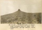 |
Volcanic neck on wagon road between Sunrise Spgs. and Biddehoche (Indian Wells), Ariz., 1909 (photo G-48) | P0013 Herbert E. Gregory Photograph Collection | P0013n02_030_254 |
| 294 |
 |
A nearer view of G-48 (volcanic neck between Sunrise Springs and Biddehoche), 1909 (photo G-49) | P0013 Herbert E. Gregory Photograph Collection | P0013n02_031_255 |
| 295 |
 |
Nearer view of volcanic neck between Sunrise Springs and Biddehoche (negative for photo G-48) | P0013 Herbert E. Gregory Photograph Collection | P0013n02_031_255_neg |
| 296 |
 |
Tuff (Tertiary) resting on red sandstone (La Plata? or McElmo?) between Sunrise Spgs. and Biddehoche (Indian Wells), Ariz., 1909 (photo G-50) | P0013 Herbert E. Gregory Photograph Collection | P0013n02_031_256 |
| 297 |
 |
Sandstone (La Plata? or McElmo?) Biddehoche (Indian Wells, Arizona, 1909 (photo G-51) | P0013 Herbert E. Gregory Photograph Collection | P0013n02_032_257 |
| 298 |
 |
Same as G-52 (Tertiary clay shales interbeddied with tuff south of Biddehoche, Ariz., 1909 (photo G-53) | P0013 Herbert E. Gregory Photograph Collection | P0013n02_032_258 |
| 299 |
 |
Same as G-52 (Tertiary clay shales interbeddied with tuff, 2± mi. south of Biddehoche, Ariz., 1909, negative for photo G-53) | P0013 Herbert E. Gregory Photograph Collection | P0013n02_032_258_neg |
| 300 |
 |
Tertiary clay shales interbeddied with tuff, 2± mi. south of Biddehoche, Ariz., 1909 (photo G-52) | P0013 Herbert E. Gregory Photograph Collection | P0013n02_032_259 |