Home
Browse
Ask Us
Chat
Harmful Language Statement
Log in
Advanced Search
Year
1867
1868
1869
1870
1871
1872
1873
1874
1875
1876
1877
1878
1879
1880
1881
1882
1883
1884
1885
1886
1887
1888
1889
1890
1891
1892
1893
1894
1895
1896
1897
1898
1899
1900
1901
1902
1903
1904
1905
1906
1907
1908
1909
1910
1911
1912
1913
1914
1915
1916
1917
1918
1919
1920
1921
1922
1923
1924
1925
1926
1927
1928
1929
1930
1931
1932
1933
1934
1935
1936
1937
1938
1939
1940
1941
1942
1943
1944
1945
1946
1947
1948
1949
1950
1951
1952
1953
1954
1955
1956
1957
1958
1959
1960
1961
1962
1963
1964
1965
1966
1967
1968
1969
1970
1971
1972
1973
1974
1975
1976
1977
1978
1979
1980
1981
1982
1983
1984
1985
1986
1987
1988
1989
1990
1991
1992
1993
1994
1995
1996
1997
1998
1999
2000
2001
2002
2003
2004
2005
2006
2007
2008
2009
2010
2011
2012
2013
2014
2015
2016
2017
2018
2019
2020
2021
2022
2023
2024
TO
1867
1868
1869
1870
1871
1872
1873
1874
1875
1876
1877
1878
1879
1880
1881
1882
1883
1884
1885
1886
1887
1888
1889
1890
1891
1892
1893
1894
1895
1896
1897
1898
1899
1900
1901
1902
1903
1904
1905
1906
1907
1908
1909
1910
1911
1912
1913
1914
1915
1916
1917
1918
1919
1920
1921
1922
1923
1924
1925
1926
1927
1928
1929
1930
1931
1932
1933
1934
1935
1936
1937
1938
1939
1940
1941
1942
1943
1944
1945
1946
1947
1948
1949
1950
1951
1952
1953
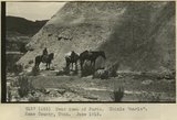
1954
1955
1956
1957
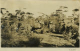
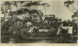
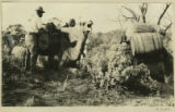
1958
1959
1960
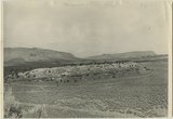
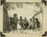
1961
1962
1963
1964
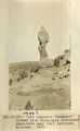
1965
1966
1967
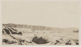
1968
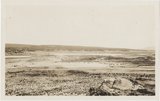
1969
1970
1971
1972
1973
1974
1975
1976
1977
1978
1979
1980
1981
1982
1983
1984
1985
1986
1987
1988
1989
1990
1991
1992
1993
1994
1995
1996
1997
1998
1999
2000
2001
2002
2003
2004
2005
2006
2007
2008
2009
2010
2011
2012
2013
2014
2015
2016
2017
2018
2019
2020
2021
2022
2023
2024
Type
Image
3,523
Text
288
Image/StillImage
149
Sound
5
Format
image/jpeg
3,602
application/pdf
1,181
Collection
44th Bomb Group - 8 Ball Tails Magazine
1
Alan K Engen Papers
2
American West Center Research Projects
12
Angus Munn Woodbury Papers
1
Athletics
13
Charles James Nabors Papers
3
Civilian Conservation Corps Newslette...
1
Classified Photographs
7
College of Law Publications
54
College of Nursing
13
Colorado Riverbed Case
2
Continuum
7
Cycling Utah
1
Electronic University Archive
49
Elias Hicks Blackburn Papers, 1848-1908
2
Everett L. Cooley Oral History Project
15
Glen Canyon
1
Graduate Nursing Project
1
Hinckley Journal of Politics
1
Historic and Prehistoric Publications
133
Honors Theses Closed Archive
1
Honors Theses Open Access
4
Illuminations
2
Intermountain Ski Instructors Associa...
10
Juanita Brooks Papers
3
Kem C. Gardner Policy Institute Colle...
1
Linford and Richards Family Collection
4
Manuscripts
4
Marriner S. Eccles Papers
19
Marriott Digital Publishing Archive
1
Marriott Library Digital Stacks
1
Marriott Library Items
1
Midvale Museum
1
Mormon Settlement in Arizona
2
NOVEL - Journal of Neuro-Ophthalmology
3
Neighborhood Partners
1
Photo Archives
3,525
Public Affairs of Health Sciences Center
4
Rare Books Collection
7
Theater Programs Collection, 1866-1995
1
Theses & Dissertations
37
UAIDA Main Collection
144
UMFA Docent Archive
1
UScholar Works
7
University of Utah Board of Regents M...
2
University of Utah Press Open Access ...
5
Uranium Oral Histories
1
Utah City Directories Collection
557
Utah Historic Building Records
60
Utah Historical Society Oral History ...
1
Utah Medical Association Bulletin
13
Utah National Register Nomination Forms
1
Utah Pharmacy Digest
6
Utah State Board Of Regents
6
Utah's Urban Pioneer Folk Music Reviv...
1
Utonian Yearbooks
13
Western Waters AZ. vs CA.
1
Western Waters Documents
4
Western Waters NEH
9
More
251
-
275
of
4,783
<
6
7
8
9
10
11
12
13
14
15
>
Gallery view
Number of results to display per page
10
25
50
100
200
Sort by Relevance
Sort by Title A-Z
Sort by Title Z-A
Sort by Date Ascending
Sort by Date Descending
Sort by Last Modified Ascending
Sort by Last Modified Descending
Title
Date
Type
Setname
251
Same as Photo G240 (Chimney Butte, Photo G241)
1911
Image
uum_map
252
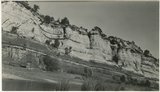
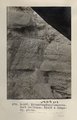
Section of the Shinarump Cliffs (middle distance), east of Pioneer Gap. Shinarump conglomerate exposed by erosion of Moenkopi formation below and the basal strata of the Chinle formation above. Upper Chinle sandstones form Vermilion Cliffs (background).
1944
Image
uum_map
253
Shanto Springs (photograph from Herbert E. Gregory Book 4: Navajo, San Juan, 1910)
1910
Image
uum_map
254
View from "Beast" dike north across Red Lake (Photo G391)
1913
Image
uum_map
255
View looking northeast up Black Creek from "Beast" dike (Photo G392)
1913
Image
uum_map
256
Wingate sandstone, includes bed of limestone. Wall of Flood Canyon. Johnson Lakes. Kane County, UT. 1943
1943
Image
uum_map
257
Herbert E. Gregory Book 1: Colorado Plateau and Grand Canyon 1900, Navajo-Hopi 1909
1900; 1909; 1928
Image
uum_map
258
Camp Steves, dune area, South Australian desert [1]
1916
Image
uum_map
259
Camp Steves, dune area, South Australian desert [2]
1916
Image
uum_map
260
Camp Steves, dune area, South Australian desert [3]
1916
Image
uum_map
261
Mangum family with Herbert E. Gregory, Paria.
1930; 1931; 1932; 1933; 1934; 1935; 1936; 1937
Image
uum_map
262
Near town of Paria. Chinle 'marls'. Kane County, UT. June 1918
1918
Image
uum_map
263
Shinarump Conglomerate. Fort Defiance. Heald & Gregory, photo (Photo G307)
1913
Image
uum_map
264
Top of Black Mesa at Onion Spgs., 12± mi. northeast of Oraibi, Ariz. (Mesa Verde strata), 1909 (photo G-95)
1909
Image
uum_map
265
"Kit Carson's Monument," eroded from Moencopie (Permian?_ sandstone near Fort Defiance, Arizona, 1909 (photo G-12)
1909
Image
uum_map
266
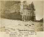
"The Church" (McElmo strata?), 4± mi southeast of Hlohala, Ariz., 1909 (photo G-107)
1909
Image
uum_map
267
Ancient landslides, 5± mi. southwest of Sunrise Spgs., Ariz. (photo G-44)
1909
Image
uum_map
268
At Grand View
1900
Image
uum_map
269
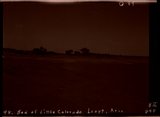
Bed of Little Colorado, Black Falls (negative for photo G-92)
1909
Image
uum_map
270
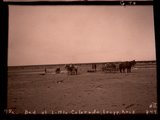
Bed of Little Colorado, Leupp, Ariz. (negative for photo G-90)
1909
Image
uum_map
271
Bed of Little Colorado, Leupp, Arizona (negative for photo G-89)
1909
Image
uum_map
272
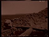
Big Burro Springs, Arizona, 1909 (negative for photo G-77)
1909
Image
uum_map
273
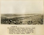
Black Creek Valley, Fort Defiance, Ariz. Looking north. Foreground and middle distance Dolores; cliffs in distance La Plata to Mesa Verde, 1909 (photo G-13)
1909
Image
uum_map
274
Buells Park, N. Ft. Defiance (negative for photo G-24)
1909
Image
uum_map
275
Buells Park, N. Ft. Defiance (negative for photo G-27)
1909
Image
uum_map
251
-
275
of
4,783
<
6
7
8
9
10
11
12
13
14
15
>