Home
Browse
Ask Us
Chat
Harmful Language Statement
Log in
Advanced Search
Year
1872
1873
1874
1875
1876
1877
1878
1879
1880
1881
1882
1883
1884
1885
1886
1887
1888
1889
1890
1891
1892
1893
1894
1895
1896
1897
1898
1899
1900
1901
1902
1903
1904
1905
1906
1907
1908
1909
1910
1911
1912
1913
1914
1915
1916
1917
1918
1919
1920
1921
1922
1923
1924
1925
1926
1927
1928
1929
1930
1931
1932
1933
1934
1935
1936
1937
1938
1939
1940
1941
1942
1943
1944
1945
1946
1947
1948
1949
1950
1951
1952
1953
1954
1955
1956
1957
1958
1959
1960
1961
1962
1963
1964
1965
1966
1967
1968
1969
1970
1971
1972
1973
1974
1975
1976
1977
1978
1979
1980
1981
1982
1983
1984
1985
1986
1987
1988
1989
1990
1991
1992
1993
TO
1872
1873
1874
1875
1876
1877
1878
1879
1880
1881
1882
1883
1884
1885
1886
1887
1888
1889
1890
1891
1892
1893
1894
1895
1896
1897
1898
1899
1900
1901
1902
1903
1904
1905
1906
1907
1908
1909
1910
1911
1912
1913
1914
1915
1916
1917
1918
1919
1920
1921
1922
1923
1924
1925
1926
1927
1928
1929
1930
1931
1932
1933
1934
1935
1936
1937
1938
1939
1940
1941
1942
1943
1944
1945
1946
1947
1948
1949
1950
1951
1952
1953
1954
1955
1956
1957
1958
1959
1960
1961
1962
1963
1964
1965
1966
1967
1968
1969
1970
1971
1972
1973
1974
1975
1976
1977
1978
1979
1980
1981
1982
1983
1984
1985
1986
1987
1988
1989
1990
1991
1992
1993
Type
Image
3,521
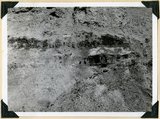
Image/StillImage
143
Format
image/jpeg
3,594
application/pdf
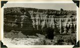
70
Collection
Photo Archives
3,521
UAIDA Main Collection
143
Filters:
Collection Name:
"Herbert E. Gregory"
251
-
275
of
3,664
<
6
7
8
9
10
11
12
13
14
15
>
Gallery view
Number of results to display per page
10
25
50
100
200
Sort by Relevance
Sort by Title A-Z
Sort by Title Z-A
Sort by Date Ascending
Sort by Date Descending
Sort by Last Modified Ascending
Sort by Last Modified Descending
Title
Date
Type
Setname
251
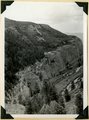
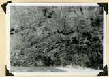
Bedded clays and lime silts. Pleistocene(?) lacustrine deposits overlain by basalt, Castro Canyon. Garfield County, UT, 1940
1940
Image
uum_map
252
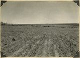
Big Plains, west dipping surface eroded on east dipping Chinle beds, now coated with coalescing fans. Little Creek Terrace in right background, Kane County, UT, 1939
1939
Image
uum_map
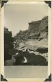
253
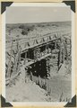
Bridge built by C.C.C. across recently eroded wash, near Pipe Springs. Mohave County, AZ. 1939
1939
Image
uum_map
254
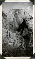
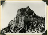
Cable Mountain, Navajo sandstone. Location of East Rim trail (center). Zion National Park
1937
Image
uum_map
255
Camp Creek near its mouth in Hurricane Cliffs. Navajo sandstone overlain by Carmel, Entrada, Curtis and Winsor. Pine Valley mountains (right distance), Washington County, UT, 1939
1939
Image
uum_map
256
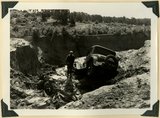
Car washed into a ravine by flood. Skutumpah-Swallow Park road
1940
Image
uum_map
257
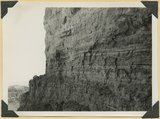
Carmel (bottom), Entrada (slope), Curtis (cliff of gypsum) and Winsor formation (top slope), Meadow Brook Canyon, Kane County, UT, 1939
1939
Image
uum_map
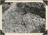
258
Carmel formation (cliff) at head of Flume Canyon upthrow (east) side of Sevier fault which trends northeasterly. Cretaceous formations (background) at level of Jurassic. Kane County, UT. 1939
1939
Image
uum_map
259
Carmel formation and Entrada (upper right) near mouth of Deep Creek. Washington County, UT, 1940
1940
Image
uum_map
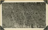
260
Carmel formation in branch of Flume Canyon. About half of total shown. Kane County, UT. 1939
1939
Image
uum_map
261
Carmel formation in Mineral Gulch. Typical arrangement of shaly and massive beds, Kane County, UT. 1939
1939
Image
uum_map
262
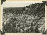
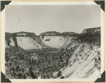
Casto Bluff head of Casto Canyon southwest edge of Sevier Plateau. Acidic lava underlain by Sevier(?) formation, Garfield County, UT, 1941
1941
Image
uum_map
263
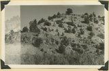
Casto Bluff, detail thick lava beds in Sevier(?) formation
1941
Image
uum_map
264
Castro Bluff, detail pumice conglomerate in Sevier formation
1941
Image
uum_map
265
Castro Bluff, detail thin beds (upper) in Sevier(?) formation
1941
Image
uum_map
266
Castro Bluff, view looking westward from its base. Terrace developed in the Sevier(?) formation at the top of the Wasatch formation
1941
Image
uum_map
267
Cave Canyon walls of Navajo sandstone, above them shale and Temple Cap member forms second cliff, capped in turn with Carmel limestone. Zion National Park
1937; 1938
Image
uum_map
268
Cedar Ridge. Cap of Shinarump conglomerate and upper Moenkopi extending south from Vermillion Cliffs onto Uinkaret Plateau west of Pipe Wash, Mohave County, AZ. 1939
1939
Image
uum_map
269
Cliffs north of highway west of Bicknell (right center). Moenkopi, Shinarump, Chinle, Wingate. Plain in foreground borders Fremont River. Wayne County, UT, 1936
1936
Image
uum_map
270
Coal in the Dakota or basal Tropic; Coal hill east side Meadow Brook. Kane County, UT
1937
Image
uum_map
271
Conglomerates, base of Timpoweep member of the Moenkopi Tarper Creek. Washington County, UT. 1941
1941
Image
uum_map
272
Consolidated river gravel (Wisconsin age?) overlying eroded Entrada(?) 300 feet above Paria River 2 miles south of Cannonville, Kane County, UT, 1939
1939
Image
uum_map
273
Contact of fossiliferous Kaibab (base) and fossiliferous Moenkopi (top), Isom Wash, Washington Co., UT, 1939. Exact contact not placed
1939
Image
uum_map
274
Contact of old and recent basalt flows near head of Gould Canyon, Washington County, UT, 1939
1939
Image
uum_map
275
Contact of Triassic and Permian (beds in wall wrinkled at base). Cherty limestone lower left. Camp Creek. Iron County, UT. 1941
1941
Image
uum_map
251
-
275
of
3,664
<
6
7
8
9
10
11
12
13
14
15
>