| Title | Date | Type | Setname | ||
|---|---|---|---|---|---|
| 226 |
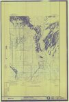 |
Gusher, Lapoint, Tridell, Utah - Reconnaissance Survey Map B | 1964 | Image/StillImage | ucl_maps |
| 227 |
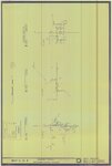 |
Gusher, Lapoint, Tridell, Utah - Reconnaissance Survey Maps C, D, & E | 1964 | Image/StillImage | ucl_maps |
| 228 |
 |
Uintah School 1906-1940 | 1906; 1907; 1908; 1909; 1910; 1911; 1912; 1913; 1914; 1915; 1916; 1917; 1918; 1919; 1920; 1921; 1922; 1923; 1924; 1925; 1926; 1927; 1928; 1929; 1930; 1931; 1932; 1933; 1934; 1935; 1936; 1937; 1938; 1939; 1940 | Image/StillImage | ucl_maps |
| 229 |
 |
Uintah School District 1 thru 7, 1910-1917 | 1910; 1911; 1912; 1913; 1914; 1915; 1916; 1917 | Image/StillImage | ucl_maps |
| 230 |
 |
Uintah School District 12 and 13, 1910-1917 | 1910; 1911; 1912; 1913; 1914; 1915; 1916; 1917 | Image/StillImage | ucl_maps |
| 231 |
 |
Uintah County Transportation 2014 | 2014 | Image/StillImage | ucl_maps |
| 232 |
 |
Vernal City Roads 2012 | 2012 | Image/StillImage | ucl_maps |
| 233 |
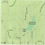 |
Uintah County Roads - Steinaker Draw, Little Valley, Red Mountain, Taylor Mountain, Carter Military Roads 2012 | 2012 | Image/StillImage | ucl_maps |
| 234 |
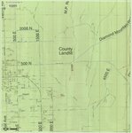 |
Vernal City Roads - Vernal Ave East to County Landfill & Diamond Mountain Road 2012 | 2012 | Image/StillImage | ucl_maps |
| 235 |
 |
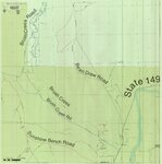
Uintah County Roads - Collier Pass, Dog Valley Roads 2012 | 2012 | Image/StillImage | ucl_maps |
| 236 |
 |
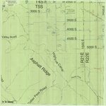
Uintah County Roads - Bean Draw, Brush Creek, Sunshine Bench Roads 2012 | 2012 | Image/StillImage | ucl_maps |
| 237 |
 |
Uintah County Roads - Dry Fork, Deep Creek, Shindy Ridge Roads 2012 | 2012 | Image/StillImage | ucl_maps |
| 238 |
 |
Uintah County R.S. 2477 Road Map | 1880; 1881; 1882; 1883; 1884; 1885; 1886; 1887; 1888; 1889; 1890; 1891; 1892; 1893; 1894; 1895; 1896; 1897; 1898; 1899; 1900; 1901; 1902; 1903; 1904; 1905; 1906; 1907; 1908; 1909; 1910; 1911; 1912; 1913; 1914; 1915; 1916; 1917; 1918; 1919; 1920; 1921; 1922; 1923; 1924; 1925; 1926; 1927; 1928; 1929; ... | Image/StillImage | ucl_maps |
| 239 |
 |
Vacation Map of Uintah County, Utah 1948 | 1948 | Image/StillImage | ucl_maps |
| 240 |
 |
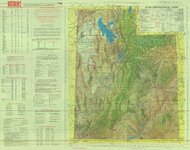
Uinta National Forest, Utah - Salt Lake Meridian & Uinta Special Meridian 1937 | 1937 | Image/StillImage | ucl_maps |
| 241 |
 |
Uintah County School, Section 36 | 1898 | Image/StillImage | ucl_maps |
| 242 |
 |
Zion National Park, Washington County (Brochure and Map) | Image/StillImage | ucl_maps | |
| 243 |
 |
Southwestern Utah, Sectional and Multipurpose Map #4 of 5 | 1975 | Image/StillImage | ucl_maps |
| 244 |
 |
Southeastern Utah, Sectional and Multipurpose Map #5 of 5 | 1975 | Image/StillImage | ucl_maps |
| 245 |
 |
Northeastern Utah - Sectional, Multipurpose Map #3 of 5 | 1975 | Image/StillImage | ucl_maps |
| 246 |
 |
Utah! National Park State | Image/StillImage | ucl_maps | |
| 247 |
 |
Utah Story Travel Council | Image/StillImage | ucl_maps | |
| 248 |
 |
Utah Aeronautical Chart 1970 | 1970 | Image/StillImage | ucl_maps |
| 249 |
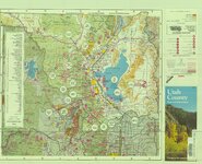 |
Utah County Map and Information Things to See and Do | Image/StillImage | ucl_maps | |
| 250 |
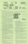 |
A Guide To Temple Square | Image/StillImage | ucl_maps |