Home
Browse
Ask Us
Chat
Harmful Language Statement
Log in
Advanced Search
Year
1830
1831
1832
1833
1834
1835
1836
1837
1838
1839
1840
1841
1842
1843
1844
1845
1846
1847
1848
1849
1850
1851
1852
1853
1854
1855
1856
1857
1858
1859
1860
1861
1862
1863
1864
1865
1866
1867
1868
1869
1870
1871
1872
1873
1874
1875
1876
1877
1878
1879
1880
1881
1882
1883
1884
1885
1886
1887
1888
1889
1890
1891
1892
1893
1894
1895
1896
1897
1898
1899
1900
1901
1902
1903
1904
1905
1906
1907
1908
1909
1910
1911
1912
1913
1914
1915
1916
1917
1918
1919
1920
1921
1922
1923
1924
1925
1926
1927
1928
1929
1930
1931
1932
1933
1934
1935
1936
1937
1938
1939
1940
1941
1942
1943
1944
1945
1946
1947
1948
1949
1950
1951
1952
1953
1954
1955
1956
1957
1958
1959
1960
1961
1962
1963
1964
1965
1966
1967
1968
1969
1970
1971
1972
1973
1974
1975
1976
1977
1978
1979
1980
1981
1982
1983
1984
1985
1986
1987
1988
1989
1990
1991
1992
1993
1994
1995
1996
1997
1998
1999
2000
2001
2002
2003
2004
2005
2006
2007
2008
2009
2010
2011
2012
2013
2014
2015
TO
1830
1831
1832
1833
1834
1835
1836
1837
1838
1839
1840
1841
1842
1843
1844
1845
1846
1847
1848
1849
1850
1851
1852
1853
1854
1855
1856
1857
1858
1859
1860
1861
1862
1863
1864
1865
1866
1867
1868
1869
1870
1871
1872
1873
1874
1875
1876
1877
1878
1879
1880
1881
1882
1883
1884
1885
1886
1887
1888
1889
1890
1891
1892
1893
1894
1895
1896
1897
1898
1899
1900
1901
1902
1903
1904
1905
1906
1907
1908
1909
1910
1911
1912
1913
1914
1915
1916
1917
1918
1919
1920
1921
1922
1923
1924
1925
1926
1927
1928
1929
1930
1931
1932
1933
1934
1935
1936
1937
1938
1939
1940
1941
1942
1943
1944
1945
1946
1947
1948
1949
1950
1951
1952
1953
1954
1955
1956
1957
1958
1959
1960
1961
1962
1963
1964
1965
1966
1967
1968
1969
1970
1971
1972
1973
1974
1975
1976
1977
1978
1979
1980
1981
1982
1983
1984
1985
1986
1987
1988
1989
1990
1991
1992
1993
1994
1995
1996
1997
1998
1999
2000
2001
2002
2003
2004
2005
2006
2007
2008
2009
2010
2011
2012
2013
2014
2015
Type
Image
4,027
Format
image/jpeg
4,027
Collection
Beckwith Photograph Collection
5
City Engineers
168
Classified Photographs
128
Extractions from the Land: Mining and...
51
Hotel Utah
108
Murray Museum
23
Park City Historical Society & Museum
98
Peoples of Utah
2
Peoples of Utah Revisited
6
Photo Archives
2,391
Regional History Center
172
Richard K. A. Kletting Architectural ...
18
Sanborn Fire Insurance Maps
6
Shipler Commercial Photographers
362
Ski and Snow Sports Archives
242
Taylor Woolley Photograph Collection
2
Thorne Photographs
39
University Archival Photographs (P0305)
54
Utah Postcards Collection, 1880s-1924
3
Utah River Running Photo Archives
60
Vernal Express Photographs
2
Westminster College Photographs
3
William Edward Hook Glass Negatives
84
More
Filters:
Type:
"Image"
Date:
"1910"
Format:
image
226
-
250
of
4,027
<
5
6
7
8
9
10
11
12
13
14
>
Gallery view
Number of results to display per page
10
25
50
100
200
Sort by Relevance
Sort by Title A-Z
Sort by Title Z-A
Sort by Date Ascending
Sort by Date Descending
Sort by Last Modified Ascending
Sort by Last Modified Descending
Title
Date
Type
Setname
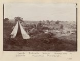
226
Camp, Pahute Mesa, Navajo Mtn in distance (Townsend photograph)
1910
Image
uum_map
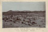
227
Canyon de Chelly near junction with Canyon del Muerto, 1910 (Edna H. Gregory photo, N-M101)
1910
Image
uum_map
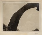
228
Cliff dwelling in Canyon de Chelly (or near mouth of del Muerto), 1910 (photo by Edna H. Gregory)
1910
Image
uum_map
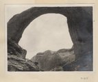
229
Looking across Navajo Canyon toward Navajo Mt. (Stephen Janus photo)
1910
Image
uum_map
230
Navajo tending sheep near Bluff (Chas. Goodman photo)
1910
Image
uum_map
231
"Sigh," the pack mule, 1910 (Photo N-M103)
1910
Image
uum_map
232
Barohoini Bridge, 1910
1910
Image
uum_map
233
Barohoini Bridge, 1910
1910
Image
uum_map
234
Barohoini Bridge, 1910
1910
Image
uum_map
235
Barohoini Bridge, looking downstream, i.e. northwest, 1910 (Photo G178A)
1910
Image
uum_map
236
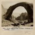
Barohoini Bridge, looking upstream, 1910
1910
Image
uum_map
237
Barohoini Bridge, looking upstream, 1910 (Photo G179)
1910
Image
uum_map
238
Barohoini Bridge, northeast arch, 1910 (Photo G180)
1910
Image
uum_map
239
Barohoini Bridge, top of arch, 1910 (Photo N-M100)
1910
Image
uum_map
240
Barohoini Natural Bridge, 10+ mi. northwest of Navajo Mt., Utah in LaPlata strata, 1910. Looking down stream northwest from distance of 1+ mi. (Photo G176)
1910
Image
uum_map
241
Base of northeast arch of Barohoini Bridge, 1910 (Photo G182)
1910
Image
uum_map
242
Branch of Navajo Canyon, Ariz., 1910 (Photo G184)
1910
Image
uum_map
243
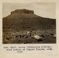
Butte (Moencopie strata), east branch of Copper Canyon, Utah, 1910 (Photo G167)
1910
Image
uum_map
244
Butte, junction Sagy canyon with middle of East Branch, Ariz., 1910 (Photo G162)
1910
Image
uum_map
245
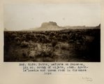
Butte, LaPlata on Dolores, 12+ mi. south of Oljato, Utah. Agathla Needle and QueenRock in distance, 1910 (Photo G159)
1910
Image
uum_map
246
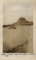
Butte, LaPlata on Dolores, 12+ mi. south of Oljato, Utah. Agathla Needle in distance, 1910 (Photo N-M91A)
1910
Image
uum_map
247
Camp 3+ mi. east of Agathla Needle, Ariz. (Photo N-M93)
1910
Image
uum_map
248
Camp in cave by spring, 8+ mi. southeast of Agathla Needle, 1910 (Photo N-M104)
1910
Image
uum_map
249
Cliff, LaPlata on Dolores at mouth of Sagy at Sosi canyon, Ariz., 1910 (Photo G166)
1910
Image
uum_map
250
Cliff-vein in Canyon de Chelly, 1910.
1910
Image
uum_map
226
-
250
of
4,027
<
5
6
7
8
9
10
11
12
13
14
>