Home
Browse
Ask Us
Chat
Harmful Language Statement
Log in
Theses & Dissertations
Advanced Search
Year
1905
1906
1907
1908
1909
1910
1911
1912
1913
1914
1915
1916
1917
1918
1919
1920
1921
1922
1923
1924
1925
1926
1927
1928
1929
1930
1931
1932
1933
1934
1935
1936
1937
1938
1939
1940
1941
1942
1943
1944
1945
1946
1947
1948
1949
1950
1951
1952
1953
1954
1955
1956
1957
1958
1959
1960
1961
1962
1963
1964
1965
1966
1967
1968
1969
1970
1971
1972
1973
1974
1975
1976
1977
1978
1979
1980
1981
1982
1983
1984
1985
1986
1987
1988
1989
1990
1991
1992
1993
1994
1995
1996
1997
1998
1999
2000
2001
2002
2003
2004
2005
2006
2007
2008
2009
2010
2011
2012
2013
2014
2015
2016
2017
2018
2019
2020
2021
TO
1905
1906
1907
1908
1909
1910
1911
1912
1913
1914
1915
1916
1917
1918
1919
1920
1921
1922
1923
1924
1925
1926
1927
1928
1929
1930
1931
1932
1933
1934
1935
1936
1937
1938
1939
1940
1941
1942
1943
1944
1945
1946
1947
1948
1949
1950
1951
1952
1953
1954
1955
1956
1957
1958
1959
1960
1961
1962
1963
1964
1965
1966
1967
1968
1969
1970
1971
1972
1973
1974
1975
1976
1977
1978
1979
1980
1981
1982
1983
1984
1985
1986
1987
1988
1989
1990
1991
1992
1993
1994
1995
1996
1997
1998
1999
2000
2001
2002
2003
2004
2005
2006
2007
2008
2009
2010
2011
2012
2013
2014
2015
2016
2017
2018
2019
2020
2021
School Or College
College of Mines & Earth Sciences
338
College of Mines and Earth Sciences
6
Department
Geology & Geophysics
344
Publication Type
thesis
344
Subject
Utah
62
Geology
59
Thesis and dissertation georeferencing project
49
Stratigraphic
10
Thesis and dissertation georeferencing project
9
Summit County
9
Cretaceous
7
Geology -- Utah -- Summit County
7
Geology -- Utah -- Tooele County
7
Geophysics
7
Coalville region
6
Geology -- Utah -- Box Elder County
6
Petrology
6
Stratigraphy
6
Wasatch County
6
Geology -- Utah -- Mineral Mountains
5
Geology--Utah
5
Grand County
5
Basalt -- Utah
4
Electric prospecting
4
Geology -- Structural -- Utah -- Willard Peak area
4
Geology -- Utah -- Weber County
4
Green River Formation
4
Sediments (Geology)
4
Uinta Basin
4
Box Elder County
3
Carbon County
3
Fluvial
3
GEMTIP
3
Geochemistry
3
Geology -- Uinta Mountains (Utah and Wyo.)
3
Geology -- Utah -- Beaver County
3
Geology -- Utah -- Juab County
3
Geology -- Utah -- Kane County -- Paria Northwest quadrangle
3
Geology -- Utah -- Sheeprock Mountains
3
Geology -- Utah -- Upton area
3
Geomorphology
3
Great Salt Lake
3
Groundwater
3
Induced polarization
3
Inversion
3
Kenya
3
Lake Bonneville
3
Moenkopi group
3
Natural gas
3
Newfoundland Mountains
3
Petrology -- Utah -- Wasatch Mountains
3
Salt Lake County
3
Sandstone
3
Sedimentology
3
Sequence stratigraphy
3
Silver Island Mountains
3
Stansbury Island
3
Tertiary
3
Thaynes Formation
3
Utah County
3
Volcanic ash
3
Wasatch Hinterland
3
Geothermal resources -- Utah
2
Alaska
2
Beaver County
2
Bonneville
2
Bruneau-Jarbidge
2
Diagenesis
2
Earthquakes
2
Frequency domain
2
Geology -- Utah -- Grassy Mountains -- Maps
2
Geology -- Utah -- Kane County
2
Geology -- Utah -- Lakeside Mountains -- Maps
2
Geology -- Utah -- Morgan County
2
Geothermal
2
Geothermal resources -- Utah
2
Gravity
2
Great Salt Lake Basin
2
Heat flow
2
Hydrologic sciences
2
Ichnology
2
John Henry Member
2
Juab County
2
Kaiparowits
2
Landslides
2
Landslides -- Utah -- Kane County
2
Mars
2
Mesozoic
2
Metamorphism
2
Methylation
2
Mines and mineral resources -- Utah -- Deep Creek Mountains
2
Mudstone
2
Oxygen isotopes
2
Paleontology
2
Petroleum
2
Polarization
2
Provenance
2
QEMSCAN
2
Shale
2
Southwestern Utah
2
Straight Cliffs
2
Stratigraphic geology
2
Tuff
2
Uinta Basin (Utah and Colo.)
2
Uinta Mountains
2
3-D focusing inversion
1
Acoustic waveform tomography
1
Alluvial Architecture
1
Alluvial architecture
1
Alta Stock
1
Ankylosauridae
1
Aquifers - Analysis - Research
1
Arches
1
Arizona
1
Axial compression
1
Axial fluvial system
1
Baenidae
1
Basin Analysis
1
Batholiths--Sierra Nevada
1
Beaver County, Cave Canyon detachment, Mineral Mountains, Sevier geothermal anomaly, southwestern Utah, Thermo Hot Springs
1
Bolide, Deep-sea, Paleoclimate, Qemscan, Sediment Velocity, XRF
1
Bonneville Lake Basin
1
Bryce Canyon National Park
1
Bryce Canyon National Park (Utah)
1
Bryce Canyon National Park Erosion
1
Building stones -- Utah -- Salt Lake City
1
CCS
1
CEMI
1
Cambrian
1
Caprock
1
Carbon dioxide
1
Carbon isotopes, Paleocene-Eocene thermal maximum
1
Carbonate
1
Cauchy-type Integral
1
Cedar City
1
Cedar Mountains
1
Centrosaurinae
1
Ceratopsidae
1
Chinle formation
1
Church Hills region
1
Circle cliffs
1
Clay -- Analysis
1
Clay mineralogy
1
Climate
1
Climate Change
1
Coal analysis
1
Coal mines and mining - Utah
1
Coke
1
Cole-cole
1
Collisional orogen
1
Colloid transport
1
Colloids
1
Colluvial wedges
1
Colorado
1
Colorado Plateau
1
Colorado plateau stratigraphy
1
Colt Mesa Mine
1
Complex resistivity
1
Conjugate gradient method
1
Controlled sensitivity
1
Cordilleran Foreland Basin
1
Core-log calibration
1
Cove Creek area
1
Crocodyliforms
1
Cyclic triaxial tests
1
Deep creek mountains
1
Dental Complexity
1
Depth to Basement
1
Detrital zircon geochronology
1
Diet
1
Dinosaur tracks
1
Duchesne County
1
Dust
1
Dynamic triggering
1
EPS
1
Early Eocene Climatic Optimum
1
Earthquake detection
1
Earthquake effects
1
Earthquake hazard analysis
1
Earthquake nucleation
1
Economics
1
Electromagnetic
1
Electronics in surveying
1
Entradichnus
1
Eocene
1
Erosion -- Utah -- Bryce Canyon National Park
1
Estuary
1
Expanded polystyrene geofoam
1
Exploration
1
FO-DTS
1
Farmington Bay
1
Fault intersections
1
Fault scarp morphology
1
Faults (Geology) -- Idaho -- Custer County Earthquakes -- Idaho -- Borah Peak
1
Faults (Geology) -- Nevada -- Lincoln County,Nye County
1
Favorable conditions
1
Feature tracking
1
Field flow fractionation
1
Filtration theory
1
Fluvial sandstone
1
Fossils
1
Fracture intensity
1
G.K. Gilbert
1
GEMTIP model
1
GSL
1
Gamma ray spectrometry
1
Geobiology
1
Geochemistry;Storglaciären
1
Geochronology
1
Geofoam
1
Geological
1
Geological mapping--Kenya
1
Geology - Kenya - Lake Turkana Region
1
Geology - Utah - Carbon County
1
Geology - Utah - Silver Island Mountains
1
Geology - Utah - Wasatch Range
1
Geology -- Kenya -- Baringo Basin
1
Geology -- Utah -- Bryce Canyon National Park
1
Geology -- Utah -- Currant Creek Formation -- Stratigraphic -- Cretaceous -- Tertiary
1
Geology -- Utah -- Desert Mountain
1
Geology -- Utah -- Dry Canyon
1
Geology -- Utah -- Durst Mountain
1
Geology -- Utah -- Ely Formation
1
Geology -- Utah -- Garfield County
1
Geology -- Utah -- Huntsville Region
1
Geology -- Utah -- Juab County -- Tintic Mining District
1
Geology -- Utah -- Ogden Valley
1
Geology -- Utah -- Oquirrh Mountains
1
Geology -- Utah -- Silver Island Mountains
1
Geology -- Utah -- Soapstone Basin
1
Geology -- Utah -- Star Range
1
Geology -- Utah -- Tooele County -- Juab County -- Ore deposits -- Tintic Mining District
1
Geology of the Parowan Gap
1
Geology of the Red Hills
1
Geology, Pennsylvanian
1
Geology, Stratigraphic
1
Geology, Stratigraphic - Cretaceous
1
Geology, Stratigraphic - Pliocene
1
Geology, Stratigraphic -- Mesozoic
1
Geology, Stratigraphic -- Paleozoic
1
Geology, Uintah Basin (Utah and Colo.)
1
Geology--Colorado
1
Geology--Kenya--Koobi Fora Region
1
Geology: Stratigraphic-Paleozoic
1
Geomagnetism -- Secular variations
1
Geophysical
1
Geoscience
1
Geothermal brines
1
Geothermal resources -- Geology-- Utah -- Beaver County
1
Gilsonite
1
Glaciers
1
Glaciology
1
Gold
1
Gold mines and mining
1
Grand Staircase-Escalante National Monument
1
Great Salt Lake (Utah)
1
Green River Fomartion
1
Groundwater - Pollution - Research
1
Groundwater -- Utah
1
Groundwater -- Utah -- Grand County -- Quality
1
Groundwater -- Utah -- Ogden Valley
1
Groundwater tracers -- Utah -- Grand County
1
Gypsum
1
H/V ratio
1
Heber
1
Helium
1
Heterodont
1
Hotspot
1
House Range
1
Hydraulic conductivity
1
Hydrocarbon recovery
1
Hydrocarbons
1
Hydrology
1
Hyperthermal Events
1
Hyperthermals
1
Hyporheic Flow
1
ICP-MS
1
Idaho
1
Igneous rocks - Utah
1
Incised Valley
1
Inclined heterolithic strata
1
Induced
1
Infrasound
1
Integral transformation
1
Integrated sensitivity
1
Interferometry
1
Intrusions (Geology)
1
Intrusions (geology)
1
Ion microprobe
1
Iron Oxide
1
Isotopic zoning
1
John henry member
1
Kaiparowits Plateau
1
Kaiparowits formation
1
Kaiparowits plateau
1
Kapusksasing Uplift
1
Kosmoceratops
1
Kuparuk River Field
1
Lacustrine
1
Lake
1
Lake Turkana
1
Lake evolution
1
Lake hydrology
1
Lake sediments, Utah, Great Salt Lake;Selenium, Utah, Great Salt Lake
1
Lakeside mountains
1
Landslide
1
Late triassic
1
Least squares
1
Lidar
1
Lothidok Range
1
Low porosity
1
Low-angle normal faulting
1
Lu-Hf
1
Lunar interior
1
MCSEM
1
Mafic gneiss
1
Magnetic gradiometry
1
Magnetotelluric
1
Malapsina Glacier
1
Mancos
1
Mancos shale
1
Marysvale
1
Marysvale, Utah--Mining
1
McArthur river mine
1
Mercury
1
Mesozoic geologic boundaries
1
Methyl Mercury
1
Mica
1
Microparticles
1
Microtremor
1
Migration
1
Mine surveying
1
Mineral Exploration
1
Mineral Mountains, Utah
1
Mineral exploration
1
Mineralogy--California--Analysis
1
Mineralogy--Indonesia--Analysis
1
Mineralogy--Utah
1
Mines and mineral resources
1
Mines and mineral resources -- Utah -- Beaver County
1
Mines and mineral resources -- Utah -- Park City District Ore deposits -- Utah -- Park City district Brecote
1
Mines and mineral resources-Beaver County
1
Mining
1
Mirabilite
1
Modeling
1
Moenkopi formation
1
Mogollon highlands, Straight Cliffs Formation
1
Moonquakes
1
Morgan County
1
Mouth Bars
1
Multiscale waveform tomography
1
Nanoparticles
1
Nasutuceratops titusi
1
National Park
1
Neotectonics
1
Nephi segment
1
Niobrara Formation
1
Noble Gas
1
Norwood Tuff
1
Nuclear discriminant
1
Nugget
1
Nutrient cycling
1
OPCR
1
Oil shale
1
Ore deposits
1
Oxygen Isotopes
1
Oxygen--Isotopes--Analysis
1
Paleobiogeography
1
Paleoclimate indicators
1
Paleoecology
1
Paleoenvironments
1
Paleontology--Kenya--Koobi Fora Region
1
Paleoseismology
1
Paleosols
1
Pecos River Valley
1
Pedogenic carbonate
1
Permeability
1
Petroleum Geology
1
Petroleum prospecting
1
Petroleum--Saudi Arabia
1
Phase tensor
1
Phylogeny
1
Piute County
1
Plasmonic metamaterials - Research
1
Pleistocene
1
Pore water
1
Potential Field Inversion
1
Potential field migration
1
Precambrian
1
Prospecting
1
Quantitative
1
Quartz
1
Quaternary geology
1
Ray tracing
1
Ray-based spatial resolution
1
Reservoir
1
Reservoir management
1
Resistivity
1
Resonance
1
Rhyolite
1
Rifts
1
River channels
1
Rock Avalanche
1
SPdKS
1
Saint Elias Mountians
1
Saline
1
Salton Sea
1
Sandstone -- Utah Sandstone -- Wyoming Sandstone -- Idaho
1
Sandstone--Utah
1
Saurian
1
ScP
1
Scott M. Matheson Wetland Preserve (Utah)
1
Sediment
1
Sedimentary Geology
1
Sedimentary basin
1
Sedimentary basins
1
Sedimentation and deformation
1
Sedimentation and deposition - Research
1
Sediments
1
Sediments (Geology) -- Utah -- Dakota Formation
1
Seepage blanket
1
Seepage meter
1
Seismic
1
Seismic Imaging
1
Seismic model
1
Seismic prospecting
1
Seismic refraction
1
Seismology
1
Seismometers
1
Seismorgrams
1
Selenium
1
Sensitivity
1
Sequence
1
Sevier thrust belt
1
Shallow shear wave velocity
1
Shelby tube
1
Signal processing
1
Siliciclastic
1
Silo Field
1
Siltsone
1
Simplified Porphry Model
1
Size-distributed media
1
Slope stability analysis
1
Smooth inversion
1
Soil Temperature;Turkana
1
Soil liquefaction
1
Soil mechanics
1
Soil organic matter
1
Soil sciences
1
Soils -- Testing
1
South Lakeside Mountains
1
Southern Utah
1
Spatial
1
Specific discharge
1
Split Stream
1
St. George
1
Stable Isotope
1
Stansbury Mountains
1
Stansbury Range
1
Straight Cliffs Formation
1
Straight cliffs formation
1
Stratigraphic-Mesozoic
1
Stratigraphy, ICSE
1
Stress-strain
1
Strontium isotopes
1
Structural
1
Structural Health Monitoring
1
Subglacial geomorphology
1
Subglacial structure
1
Sunnyside oil-impregnated sandstone
1
Superior Province
1
Superior craton
1
Surface water
1
Tectonic geomorphology
1
Thalassinoides
1
Thermal conductivity
1
Thesis and dissertation dereferencing project
1
Ti thermometer
1
Tidal
1
Time domain
1
Time-domain analysis
1
Time-domain reflectometry
1
Tomographic imaging
1
Tooele County
1
Topography
1
Tourmaline--Analysis
1
Trace
1
Trace Elements
1
Trace fossil
1
Tree rings
1
U-Pb geochronology
1
ULVZ
1
Uinta County
1
Unconventional
1
Upper Cambrian
1
Upper Cretaceous
1
Uranium
1
Uranium mines and mining
1
Uranium mining
1
Utah-Star Range
1
Utahceratops
1
Vein
1
Visualization
1
Volcanic ash, tuff, etc -- Kenya -- Baringo Basin
1
Volcanism -- Nevada -- Lincoln County, Nye County
1
Volume Integral Method
1
Wanship region
1
Wasatch Fault Zone
1
Wasatch Mountains
1
Wasatch Plateau - Utah
1
Wasatch Range (Utah and Idaho)
1
Wasatch fault
1
Washington fault
1
Water exchange
1
Water levels
1
Water pollution--Utah
1
Water resources management
1
Western Interior Seaway
1
Western United States
1
Western interior basin
1
Western interior seaway
1
Wetland
1
Wetlands
1
Wyoming
1
Yellowstone
1
Yellowstone hotspot
1
Zhdanov
1
Zion National Park
1
Zircon
1
allogenic and allogenic controls
1
biogeography
1
bioherm
1
caddisfly
1
caldera
1
carbonate
1
ceratopsid
1
chasmosaurine
1
core-mantle boundary
1
cross-correlation
1
detection
1
dissolved gas
1
earthquake
1
environmental tracer
1
evolution
1
exploration
1
exsolution
1
fertility
1
fluvial channel-belts
1
gas
1
geochemistry
1
groundwater
1
groundwater age
1
helium
1
helium isotopes
1
histology
1
hotspot
1
hydrogeology
1
lacustrine
1
late cretaceous
1
lidar
1
mercury
1
microbialite
1
mineralization
1
mining
1
modeling
1
multicollector
1
paleolake
1
paleontology
1
petrology
1
phylogeny
1
porphyry
1
pull-apart basin
1
python
1
sampling techniques
1
seismic
1
seismic wave propagation
1
shorelines
1
spatial analysis
1
stacking patterns
1
stodks (geology)
1
storage
1
stratigraphy
1
stromatolites
1
subsidence
1
swarm
1
tectonics
1
transit time
1
vector
1
volcanism
1
watershed
1
More
Filters:
Department:
"Geology & Geophysics"
Publication Type:
"thesis"
Collection:
"ir_etd"
226
-
250
of
344
<
5
6
7
8
9
10
11
12
13
14
>
Gallery view
Number of results to display per page
10
25
50
100
200
Sort by Relevance
Sort by Title A-Z
Sort by Title Z-A
Sort by Date Ascending
Sort by Date Descending
Sort by Last Modified Ascending
Sort by Last Modified Descending
Author
Title
Subject
Date
Publication Type
226
Moussa, Mounir Tawfik
Geology of the Soldier Summit quadrangle, Utah (Thesis and maps)
Geology; Utah; Utah County; Carbon County; Wasatch County
1965-06
thesis
227
Chapusa, Frank W. P.
Geology and structure of Stansbury Island (Thesis and maps)
Geology; Utah; Stansbury Island
1969-06
thesis
228
Staub, Ann Marie
Geology of the Picture Rock Hills quadrangle, Southwestern Keg Mountains, Juab County, Utah (Thesis and maps)
Geology; Utah; Juab County
1975
thesis
229
Mann, Daven Craig
Clastic laramide sediments of the Wasatch Hinterland, Northeastern Utah (Thesis and maps)
Sediments (Geology); Utah; Wasatch Hinterland
1974
thesis
230
Winkler, Gary Ralphs
Sedimentology and geomorphic significance of the bishop conglomerate and the Browns Park Formation, Eastern Uinta Mountains, Utah, Colorado, And Wyoming (Thesis and maps)
Sediments (Geology); Uinta Mountains; Structural; Stratigraphic; Tertiary; Thesis and dissertation georeferencing project
1970-06
thesis
231
Zimmerman, James T.
Geology of the Cove Creek area Millard County and Beaver County, Utah
Geology; Utah; Cove Creek area; Thesis and dissertation georeferencing project
1961-06
thesis
232
Paddock, Robert Edwards
Geology of the Newfoundland Mountains, Box Elder County, Utah
Geology; Utah; Newfoundland Mountains; Box Elder County
1956-12
thesis
233
Vlam, Heber Adolf Arien
Petrology of Lake Bonneville Gravels Salt Lake County, Utah
Petrology; Utah; Salt Lake County; Bonneville; Thesis and dissertation georeferencing project
1963-05
thesis
234
Earll, Fred Nelson
Geology of the Central Mineral Range, Beaver County, Utah
Geology -- Utah -- Mineral Mountains; Geology -- Utah -- Beaver County
1957-08
thesis
235
Gardner, Philip Michael
Environmental tracer investigation of groundwater conditions at the Scott M. Matheson Wetland Preserve near Moab, Utah
Groundwater -- Utah -- Grand County -- Quality ; Groundwater tracers -- Utah -- Grand County ; Scott M. Matheson Wetland Preserve (Utah)
2004-08
thesis
236
Sadeghi, Ali Reza
Plate 2: Structure sections for geologic map of the Willard Peak area
1972-12
thesis
237
Blakey, Ronald Clyde
Plate 2: Structural sections
1970-08
thesis
238
Blakey, Ronald Clyde
Plate 3: Structural map of the Paria NW quadrangle, Kane County, Utah
1970-08
thesis
239
Neff, Thomas Rodney
Plate 3: Structural map of the Little Willow Series, Wasatch Mountains, Utah
1962-11
thesis
240
Neff, Thomas Rodney
Plate 1: Geologic map of the Little Willow Series, Wasatch Mountains, Utah
1962-11
thesis
241
Sadeghi, Ali Reza
Plate 3: Palinspastic middle and upper Cambrian columnar sections from western and northern Utah
1972-12
thesis
242
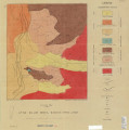
Blakey, Ronald Clyde
Plate 4: Topographic features of the Paria NW quadrangle, Kane County, Utah
1970-08
thesis
243
Neff, Thomas Rodney
Plate 2: Sections along line A-A' and B-B'
1962-11
thesis
244
Schaeffer, Frederick Ernst Jr.
Plate 1C: Geologic cross sections of the Central and Southern Silver Island Mountains, Box Elder and Tooele Counties, Utah and Elko County, Nevada
1961-06
thesis
245
Sadeghi, Ali Reza
Plate 4: Correlation of Precambrian rocks of the lower plate and upper plate of the Willard thrust with the Huntsville and Cottonwood areas
1972-12
thesis
246
Neff, Thomas Rodney
Plate 4: Map variations of the Little Willow Series, Wasatch Mountains, Utah
1962-11
thesis
247
Schaeffer, Frederick Ernst Jr.
Plate 1B: Geologic map of the Central and Southern Silver Island Mountains, Box Elder and Tooele Counties, Utah, and Elko County, Nevada
1961-06
thesis
248
Blakey, Ronald Clyde
Plate 3: Structural sections
1970-08
thesis
249
Blakey, Ronald Clyde
Plate 1: Geologic map of the Paria NW quadrangle, Kane County, Utah
1970-08
thesis
250
Sadeghi, Ali Reza
Plate 1: Geologic map of the Willard Peak area, North-Central Wasatch Mountains, Utah
1972-12
thesis
226
-
250
of
344
<
5
6
7
8
9
10
11
12
13
14
>