Home
Browse
Ask Us
Chat
Harmful Language Statement
Log in
Advanced Search
Year
1830
1831
1832
1833
1834
1835
1836
1837
1838
1839
1840
1841
1842
1843
1844
1845
1846
1847
1848
1849
1850
1851
1852
1853
1854
1855
1856
1857
1858
1859
1860
1861
1862
1863
1864
1865
1866
1867
1868
1869
1870
1871
1872
1873
1874
1875
1876
1877
1878
1879
1880
1881
1882
1883
1884
1885
1886
1887
1888
1889
1890
1891
1892
1893
1894
1895
1896
1897
1898
1899
1900
1901
1902
1903
1904
1905
1906
1907
1908
1909
1910
1911
1912
1913
1914
1915
1916
1917
1918
1919
1920
1921
1922
1923
1924
1925
1926
1927
1928
1929
1930
1931
1932
1933
1934
1935
1936
1937
1938
1939
1940
1941
1942
1943
1944
1945
1946
1947
1948
1949
1950
1951
1952
1953
1954
1955
1956
1957
1958
1959
1960
1961
1962
1963
1964
1965
1966
1967
1968
1969
1970
1971
1972
1973
1974
1975
1976
1977
1978
1979
1980
1981
1982
1983
1984
1985
1986
1987
1988
1989
1990
1991
1992
1993
1994
1995
1996
1997
1998
1999
2000
2001
2002
2003
2004
2005
2006
2007
2008
2009
2010
2011
2012
2013
2014
2015
TO
1830
1831
1832
1833
1834
1835
1836
1837
1838
1839
1840
1841
1842
1843
1844
1845
1846
1847
1848
1849
1850
1851
1852
1853
1854
1855
1856
1857
1858
1859
1860
1861
1862
1863
1864
1865
1866
1867
1868
1869
1870
1871
1872
1873
1874
1875
1876
1877
1878
1879
1880
1881
1882
1883
1884
1885
1886
1887
1888
1889
1890
1891
1892
1893
1894
1895
1896
1897
1898
1899
1900
1901
1902
1903
1904
1905
1906
1907
1908
1909
1910
1911
1912
1913
1914
1915
1916
1917
1918
1919
1920
1921
1922
1923
1924
1925
1926
1927
1928
1929
1930
1931
1932
1933
1934
1935
1936
1937
1938
1939
1940
1941
1942
1943
1944
1945
1946
1947
1948
1949
1950
1951
1952
1953
1954
1955
1956
1957
1958
1959
1960
1961
1962
1963
1964
1965
1966
1967
1968
1969
1970
1971
1972
1973
1974
1975
1976
1977
1978
1979
1980
1981
1982
1983
1984
1985
1986
1987
1988
1989
1990
1991
1992
1993
1994
1995
1996
1997
1998
1999
2000
2001
2002
2003
2004
2005
2006
2007
2008
2009
2010
2011
2012
2013
2014
2015
Type
Image
4,221
Format
image/jpeg
4,221
Collection
Beckwith Photograph Collection
1
City Engineers
149
Classified Photographs
65
Extractions from the Land: Mining and...
51
Hotel Utah
150
Murray Museum
13
Park City Historical Society & Museum
98
Peoples of Utah Revisited
2
Photo Archives
2,390
Regional History Center
120
Richard K. A. Kletting Architectural ...
6
Sanborn Fire Insurance Maps
368
Sanborn Fire Insurance Maps, Division...
42
Shipler Commercial Photographers
361
Ski and Snow Sports Archives
137
Taylor Woolley Photograph Collection
46
Thorne Photographs
32
University Archival Photographs (P0305)
44
Utah Postcards Collection, 1880s-1924
3
Utah River Running Photo Archives
56
Vernal Express Photographs
1
Westminster College Photographs
2
William Edward Hook Glass Negatives
84
More
Filters:
Date:
"1911"
Type:
"Image"
Format:
"image/jpeg"
Format:
image
226
-
250
of
4,221
<
5
6
7
8
9
10
11
12
13
14
>
Gallery view
Number of results to display per page
10
25
50
100
200
Sort by Relevance
Sort by Title A-Z
Sort by Title Z-A
Sort by Date Ascending
Sort by Date Descending
Sort by Last Modified Ascending
Sort by Last Modified Descending
Title
Date
Type
Setname
226
Lake, East terrace Choiskai Mt.
1911
Image
uum_map
227
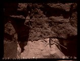
Unconformity
1911
Image
uum_map
228
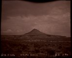
White Cone (Photo G256)
1911
Image
uum_map
229
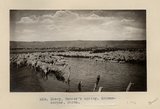
Sheep, Tanner's spring. Schwemberger, photo
1911
Image
uum_map
230
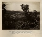
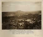
Todilto park looking northwest from east rim. Mrs. Gregory, photo. 1911 (Photo N-M116)
1911
Image
uum_map
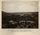
231
Todilto park, looking south. Defiance Mesas in skyline. Heald, photo. 1911 (Photo N-M117)
1911
Image
uum_map
232
Todilto park, looking west from east rim. Mrs. Gregory, photo. 1911 (Photo N-M115)
1911
Image
uum_map
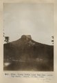
233
Tse-na-kahn (Round Rock), from southeast. New Mexico. Heald, photo. 1911 (Photo N-M128)
1911
Image
uum_map
234
Tubby Butte near Tsa-lee. Looking east. Heald, photo, 1911 (Photo G296)
1911
Image
uum_map
235
Erosion column on Defiance-Tohatchie road, West of Tohatchie, NM, near top of Cretaceous. Mrs. Gregory, photo. 1911 (Photo G200)
1911
Image
uum_map
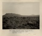
236
General view, Moqui Buttes, Biddehoche Section. Barrows, photo. 1911 (Photo G234)
1911
Image
uum_map
237
Cottonwood Pass. Extreme crest, west slope. Mrs. Gregory, photo. 1911 (Photo G209)
1911
Image
uum_map
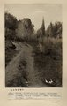
238
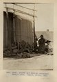
Arnold and family (Chinlee) Navajo loom. Heald, photo, 1911 (Photo G282)
1911
Image
uum_map
239
Bad lands, Chinle strata in Hopi Buttes region, north east of Holbrook, Ariz. USGS, probably Darton
1911
Image
uum_map
240
Baigaiche Mt., looking south across mouth of Black creek where it emerges from Todilto Park. Mrs. Gregory, photo. 1911 (Photo N-M118)
1911
Image
uum_map
241
Cliffs west of Cornfields, south of Ganado; on west side of Pueblo Colorado Wash. Heald, 1911 (Photo N-M123)
1911
Image
uum_map
242
Lava cliffs near Whiskey Creek (Palisades). Heald, photo. 1911 (Photo N-M130)
1911
Image
uum_map
243
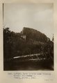
Lava-capped butte, near Stiles ranche. Barrows, photo (Photo G244)
1911
Image
uum_map
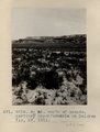
244
3± mi. north of Ganado. Tertiary unconformable on Dolores. VII, 19. 1911 (Photo G218)
1911
Image
uum_map
245
Another view of Photo G213. VI, 38 (Photo G213A)
1911
Image
uum_map
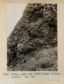
246
Ash and tuff near Biddehoche. VI, 84 (Photo G231)
1911
Image
uum_map
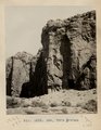
247
Ash, Twin Buttes (Photo G252)
1911
Image
uum_map
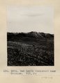
248
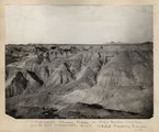
Bad Lands (Dolores) near Chinlee. VII, 26 (Photo G271)
1911
Image
uum_map
249
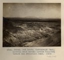
Bad Lands, Cottonwood Wash. 1909 (photograph from Herbert E. Gregory Book 5: Navajo, 1911)
1911
Image
uum_map
250
Bad Lands, Dolores. Lower Pueblo Colorado Wash. Section VI, 79-80. 1911 (Photo G226)
1911
Image
uum_map
226
-
250
of
4,221
<
5
6
7
8
9
10
11
12
13
14
>