Home
Browse
Ask Us
Chat
Harmful Language Statement
Log in
Advanced Search
Year
1880
1881
1882
1883
1884
1885
1886
1887
1888
1889
1890
1891
1892
1893
1894
1895
1896
1897
1898
1899
1900
1901
1902
1903
1904
1905
1906
1907
1908
1909
1910
1911
1912
1913
1914
1915
1916
1917
1918
1919
1920
1921
1922
1923
1924
1925
1926
1927
1928
1929
1930
1931
1932
1933
1934
1935
1936
1937
1938
1939
1940
1941
1942
1943
1944
1945
1946
1947
1948
1949
1950
1951
1952
1953
1954
1955
1956
1957
1958
1959
1960
1961
1962
1963
1964
1965
1966
1967
1968
1969
1970
1971
1972
1973
1974
1975
1976
1977
1978
1979
1980
1981
1982
1983
1984
1985
1986
1987
1988
1989
1990
1991
1992
1993
1994
1995
1996
1997
1998
1999
2000
2001
2002
2003
2004
2005
2006
2007
2008
2009
2010
2011
2012
2013
2014
2015
TO
1880
1881
1882
1883
1884
1885
1886
1887
1888
1889
1890
1891
1892
1893
1894
1895
1896
1897
1898
1899
1900
1901
1902
1903
1904
1905
1906
1907
1908
1909
1910
1911
1912
1913
1914
1915
1916
1917
1918
1919
1920
1921
1922
1923
1924
1925
1926
1927
1928
1929
1930
1931
1932
1933
1934
1935
1936
1937
1938
1939
1940
1941
1942
1943
1944
1945
1946
1947
1948
1949
1950
1951
1952
1953
1954
1955
1956
1957
1958
1959
1960
1961
1962
1963
1964
1965
1966
1967
1968
1969
1970
1971
1972
1973
1974
1975
1976
1977
1978
1979
1980
1981
1982
1983
1984
1985
1986
1987
1988
1989
1990
1991
1992
1993
1994
1995
1996
1997
1998
1999
2000
2001
2002
2003
2004
2005
2006
2007
2008
2009
2010
2011
2012
2013
2014
2015
Type
Image
6,870
Text
6
Format
image/jpeg
6,821
application/pdf
49
Collection
Civilian Conservation Corps
73
Classified Photographs
1
Connell O'Donovan LGBT Utah History C...
24
Eccles Health Sciences Library History
1
Extractions from the Land: Mining and...
1
Hidden Water - Salt Lake County Water...
1
History of the Health Sciences at the...
1
Hotel Utah
13
Lennox and Catherine Tierney Photogra...
1,067
Manuscripts
11
Marriott Library Posters
1
Murray Museum
56
Park City Historical Society & Museum
2
Peoples of Utah Revisited
20
Photo Archives
483
Regional History Center
31
Right Whale Collection
1,437
Right Whale Notes Collection
40
School of Medicine
5
Ski and Snow Sports Photo Archives
1,842
University Archival Photographs (P0305)
1,731
Utah Religious Architecture Photographs
1
Utah River Running Photo Archives
26
Westminster University Photographs
2
More
Filters:
Type:
"Image"
1676
-
1700
of
6,870
<
63
64
65
66
67
68
69
70
71
72
>
Gallery view
Number of results to display per page
10
25
50
100
200
Sort by Relevance
Sort by Title A-Z
Sort by Title Z-A
Sort by Date Ascending
Sort by Date Descending
Sort by Last Modified Ascending
Sort by Last Modified Descending
Title
Date
Type
Setname
1676
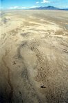
An ancient bed of river that drained into Lake Bonneville.
1995-03-14
Image
uum_map
1677
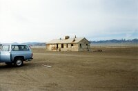
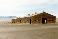
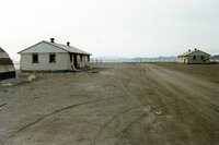
Barracks, munitions storage bunkers, other buildings at Wendover Air Base (abandoned)
1995-03-14
Image
uum_map
1678
Barracks, munitions storage bunkers, other buildings at Wendover Air Base (abandoned)
1995-03-14
Image
uum_map
1679
Barracks, munitions storage bunkers, other buildings at Wendover Air Base (abandoned)
1995-03-14
Image
uum_map
1680
Barracks, munitions storage bunkers, other buildings at Wendover Air Base (abandoned)
1995-03-14
Image
uum_map
1681
Barracks, munitions storage bunkers, other buildings at Wendover Air Base (abandoned)
1995-03-14
Image
uum_map
1682
Barracks, munitions storage bunkers, other buildings at Wendover Air Base (abandoned)
1995-03-14
Image
uum_map
1683
Bonneville Salt Flats
1995-03-14
Image
uum_map
1684
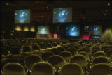
The Cliff Lodge interior: Ballroom
1995-09-01
Image
uum_map_usa
1685
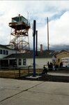
Control tower at Wendover Air Base (abandoned)
1995-03-14
Image
uum_map
1686
Control tower at Wendover Air Base (abandoned)
1995-03-14
Image
uum_map
1687
Corey Engen, Alta, 1995.
1995-04-21
Image
uum_map_usa
1688
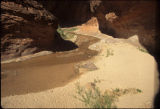
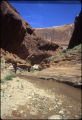
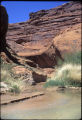
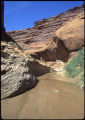
Coyote Gulch, Utah [09]
1995-04-11
Image
uum_map
1689
Coyote Gulch, Utah [27]
1995-04-11
Image
uum_map
1690
Coyote Gulch, Utah [46]
1995-04-11
Image
uum_map
1691
D. Athletics - Volleyball Fd 04 #137
1995; 1996; 1997
Image
uum_uapp0305
1692
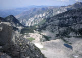
Drainage looking north from Lone Peak
1995-09-11
Image
uu_hw_slcwd
1693
Dugway Pass, south of UTTR
1995-03-14
Image
uum_map
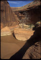
1694
Escalante River meets Coyote Gulch, Utah [04]
1995-04-11
Image
uum_map
1695
Escalante River meets Coyote Gulch, Utah [05]
1995-04-11
Image
uum_map
1696
Great Salt Lake dikes
1995-03-14
Image
uum_map
1697
Gun emplacements used as part of UTTR, Lakeside Mountains
1995-03-14
Image
uum_map
1698
I-80 and salt flats
1995-03-14
Image
uum_map
1699
I-80 looking west
1995-03-14
Image
uum_map
1700
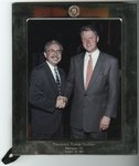
Ibarra and President Clinton, President's Trustee luncheon
1995-10-25
Image
uum_map
1676
-
1700
of
6,870
<
63
64
65
66
67
68
69
70
71
72
>